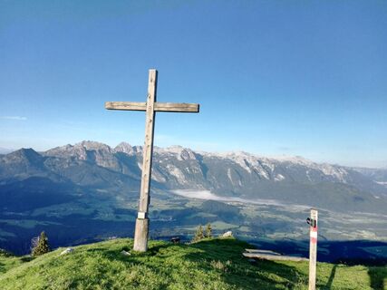
From the car park, hike up the forest road or directly from the car park through the forest path. At the beginning you reach the forest road again, but soon turn left again into the forest path (path no. 23). After about 40 minutes, you reach the forest road again and hike about 500 m to the left to turn right again into the forest path at the signposts. There is another climb until you leave the forest and reach the Taborberg (1618 m, 7 points) across open terrain. If you want to take it a little easier, you can also reach the Tabor contrary to the signs. You simply have to follow the forest road. This makes the ascent longer, but it is a steady, gentle climb (approx. 2.5 hours / 660 m). Halfway up, you have the option of turning right (trail no. 23a) and continuing towards the Postalm or Russbach. Past the Turnaualm to the next junction (right to the Rinnbergalm and on to Rußbach), straight on via the Moosbergalm to the Postalm (Austria's largest alpine plateau).
Yes
appropriate hiking clothes, hiking boots, hiking poles are for the benefit
There are no special skills required.
From Abtenau town center direction Rußbach. At the "Schwaighof Bridge" (Pointinger Materials) left and then immediately turn right (green blackboard "Radochsberg" follow). Drive to the "Stockerbauer" Farmer , there you can park.
With public transportation, unfortunately, only to stop "Abtenau Hacergraben" possible. From there you have to walk 45 min to the parking Astein where the hike to the Tabor mountain starts.
Free Parking at "Stockerbauer" Farmer
Enjoy the magnificent view of Abtenau and the Tennengebirge at the top!
Webcams of the tour
Popular tours in the neighbourhood
Don't miss out on offers and inspiration for your next holiday
Your e-mail address has been added to the mailing list.


