


Discovering a beautiful itinerary, on the border with Switzerland, which from the hamlet of Isella reaches that of Cursolo through dense beech woods and where it is possible to observe the ancient furnaces...
Discovering a beautiful itinerary, on the border with Switzerland, which from the hamlet of Isella reaches that of Cursolo through dense beech woods and where it is possible to observe the ancient furnaces for working iron (Valle del Ferro in the Municipality of Re) , the woods exploited for the production of coal which was used to fuel the furnaces and for the war industry (presence of coal yards) and the minerals which were used for the extraction of iron. Along the route there are bivouacs, refuges and hostels where you can stop.

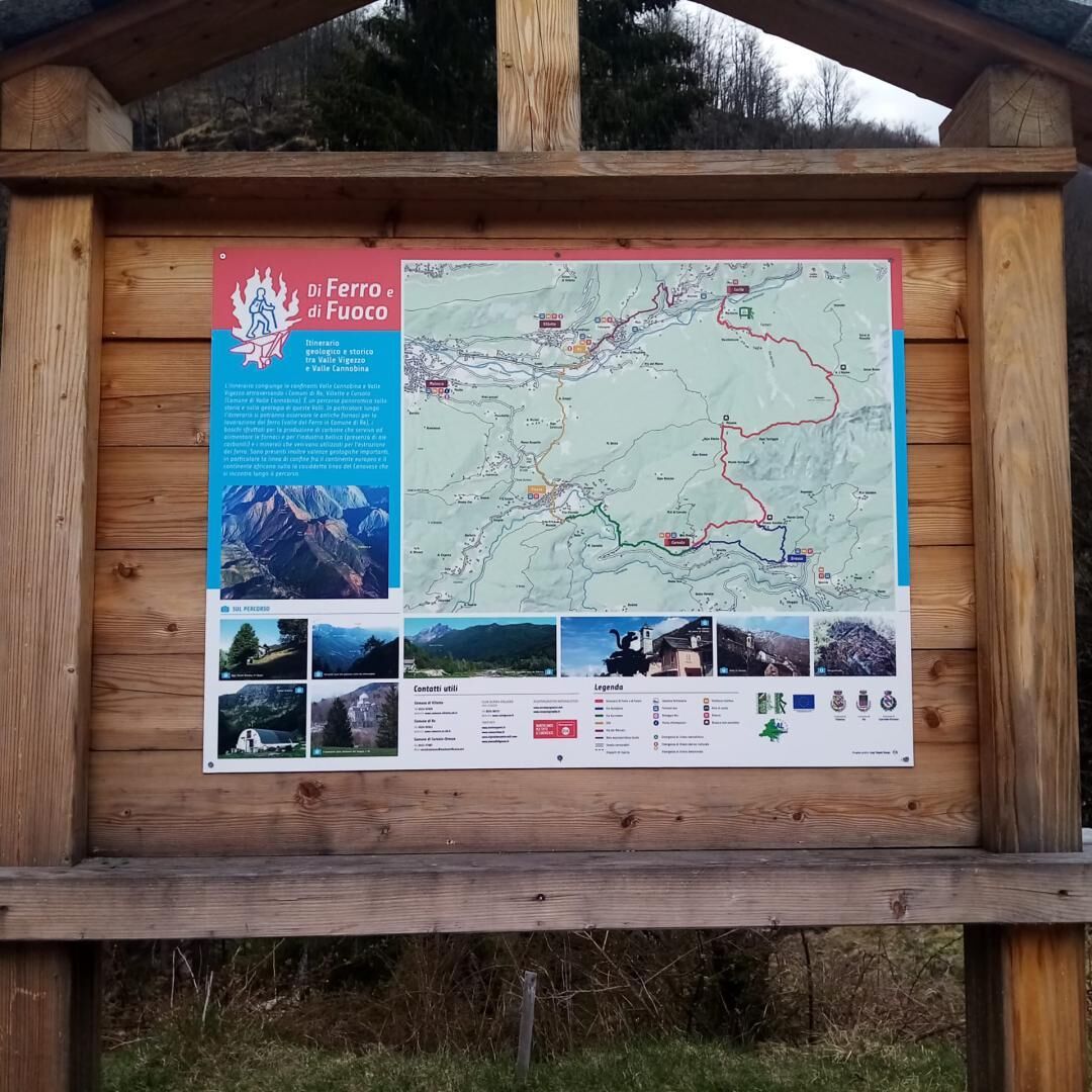
The itinerary starts from Isella (620 m above sea level), on the road that goes from Re to the border of Ponte Ribellasca. From the Isella car park, cross the state road and take the path (VBAM22) that goes up to Alpe Vaccareggio (journey time 1 hour) near the Rio del Ferro. From the alp you continue on the same path, which crosses thick beech woods, until you reach the l'Alpino alp (1273 m above sea level - travel time (1 h 25') where you will find a bivouac where you can stop. Along the along the route it is possible to observe the ancient furnaces for working iron (Valle del Ferro in the Municipality of Re), the woods exploited for the production of coal which was used to fuel the furnaces and for the war industry (presence of coal yards) and the minerals which were used for the extraction of iron. There are also important geological features, in particular the border line between the European continent and the African continent on the so-called Canavese line which is encountered along the route. After leaving the Alpe Alpino you take the path (VBAS18) which climbs towards Mount Torrigia passing under the rocks of Gridone. The itinerary develops along some rocky sections, well signposted, on which you need to pay attention. Crossing the locality Piano delle Streghe (Pian di Strìi - 1690 m above sea level), where legends tell of witches and sorcerers from the borderlands between Italy and Switzerland, continue on the same path until descending to Pluni (Polunia 1461 m above sea level) where there is a bivouac (journey time 1 h 50') . From this alp you can enjoy one of the most beautiful views of the Cannobina Valley. From Alpe Pluni take the path which, going around Monte Torriggia on the Cannobino side, leads to Monte Vecchio (1094 m above sea level - travel time 1 h 20') where there is a nice refuge where you can stop. From Monte Vecchio take the path (VBAS16A) that leads to Cursolo (886 m asl – travel time 40'). In Cursolo it is possible to stop at the hostel. There is also a refreshment point and the possibility of taking a bus back.
Yes
Appropriate equipment and footwear for a high altitude excursion is recommended.
Popular tours in the neighbourhood
- 3,3
Cannobio zu Sant’Aagata
lightHiking5,85 km - 4,5
Sculpture path
lightThematic route2,49 km - 5,0
Cicogna, Strada Sutermeister, Alpe Pogallo, Alpe Pra, Cicogna
mediumHiking9,83 km - 5,0
Himmel
mediumHiking12,7 km - 5,0
Mergugno: in the yellow forest
mediumHiking6,44 km - 5,0
Loco - Vosa - Intragna
mediumHiking5,96 km Centres of energy in the Ghiridone
mediumThematic route7,35 kmSpruga-Alpe Saléi-Comologno
mediumHiking8,96 km- 5,0
Oggonio
lightHiking7,55 km - 4,3
Pian Cavallone
lightHiking7,55 km
Hiking & Tracking


Don't miss out on offers and inspiration for your next holiday
Your e-mail address has been added to the mailing list.