Information
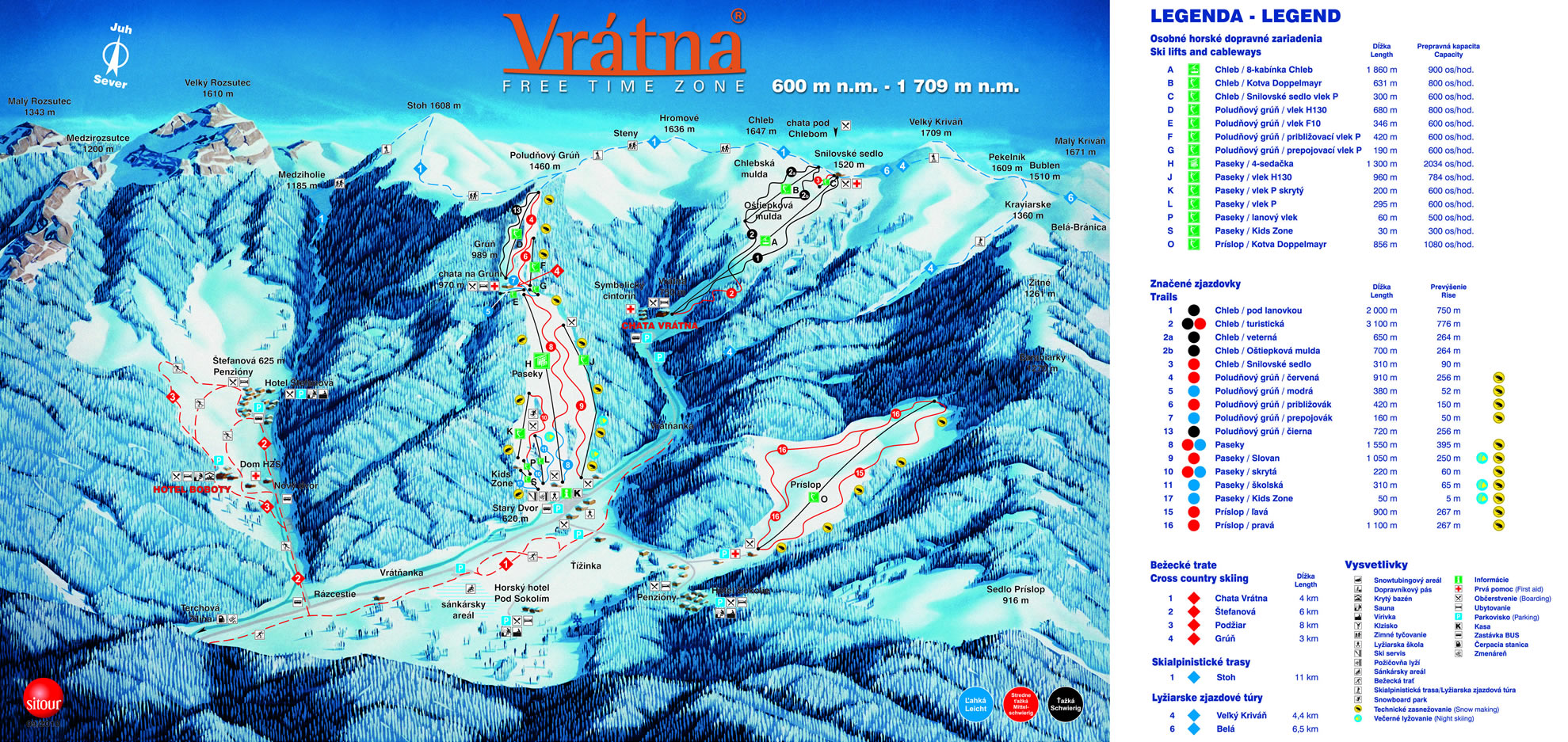
Paseky / Poludnovy Grun / Prislop / Chleb
- Location: Mala Fatra National Park
- Altitude: 600-1709 m.
- Evaluation by Lavex / Sitour: 5 * (in 2009-2013)
- Ski Centre Locations: Paseky (600-990 m), Poludnovy Grun (945 to 1220 m), Chleb (740 to 1520 m), Prislop (670 to 925 m)
- ski lifts + cable-car + chairlift: 12 + 1 + 1
- total capacity of lifts: 10 850 pers / h
- ski runs /...
Read more
Information
Paseky / Poludnovy Grun / Prislop / Chleb
- Location: Mala Fatra National Park
- Altitude: 600-1709 m.
- Evaluation by Lavex / Sitour: 5 * (in 2009-2013)
- Ski Centre Locations: Paseky (600-990 m), Poludnovy Grun (945 to 1220 m), Chleb (740 to 1520 m), Prislop (670 to 925 m)
- ski lifts + cable-car + chairlift: 12 + 1 + 1
- total capacity of lifts: 10 850 pers / h
- ski runs / total length: 17 / 14 km
- ski runs difficulty: easy: 4 ½ (1000 m in length), moderate: 8 (7900 m in length), challenging: 4 ½ (5700 m in length)
- lenght of artificial snow-covered runs: 7800 m (snow cannons: 36 pcs)
- length of illuminated runs: 1500 m
- length of regularly maintained runs: 8000 m (snow tracked vehicles: 4 pcs)
- the longest trail with the highest elevation: "Turisticka" in the Chleb area (3100 m / 776 m)
- cross-country skiing: 22 km, alpine skiing: 19 km
- freeride zone: up to 1709 m
- for kids: babysitting, children's park Kids Zone with a conveyor belt Sunkids, Paseky
- winter season: December - April (snow cover guarantee: min. 120 days a year)
- free parking in the resort, free bus from/to Zilina
Down the Vratna valley, ski with everybody!
Source: zima.vratna.sk/en/stredisko-info
Contact us

Contact us


Ski, snow & weather


Extensive information on all ski resorts in Europe. Slope maps, snow depths, webcams and more guarantee maximum fun on the slopes.

Newsletter
Our newsletter informs you about attractive vacation offers, events, competitions and much more.
Subscribe to the newsletter
Favourite ski resorts
SKI ORAVICE Meander Skipark
Roháče - Spálená dolina
Zuberec - Milotín
Vrátna Free Time Zone
SKI PARK Kubínska hoľa
Winter Park Martinky
SNOWLAND – Valčianska dolina
Orava Snow - Oravská Lesná
SKI centrum Brezovica Casa Mia
Skalité - Serafínov
Jasenská dolina
Snow Paradise Veľká Rača
Čertovica
Žiar - Dolinky
SKI VITANOVÁ Vrchdolinky
Ski Centrum Čertovica
Veľké Ostré
Jasná Nízke Tatry / Chopok
Malinô Brdo - Ružomberok
Krušetnica