Winter
Summer
Weather
Webcams
Accommodations
Tours
Search history
Search suggestions
No results found
Search
Tours
Home
Summer Österreich
Salzburg
Tours
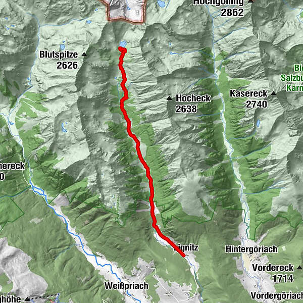
bergfextour_lignitzsee.gpx
Ski resorts
Snow parks
Cross-country skiing
Weather
Webcams
Snow reports
Accommodations
Offers
Sports provider
Events
Summer
Tours
bergfextour_lignitzsee.gpx
Hiking
Bookmark
Map
show
hide
Print
Tour data
8.56
km
1,334 - 1,973
m
Distance
694
hm
61
hm
Ascent
02:38
h
Duration
Koen De Wit
created am 22.07.2019
2
Views
(Status: unofficial)
Highest point
1,973 m
Report tour
GPS Downloads
GPX
GPS Exchange Format (XML)
KML
Google Earth, Google Maps
QR Download Codes for Mobile Phones
bergfextour_lignitzsee.gpx
QR Codes - tour download for cell phones
GPX
KML
Other tours in the regions
Katschberg Lieser-Maltatal
2574
Lungau - Ferienregion
871
Weißpriach
207
Popular tours in the area
Schladming - Hochgolling
difficult
Hiking
20.64
km |
1731
hm |
10:30
h
Drei-Seen-Wanderung (Steirischer Bodensee - Hüttensee - Obersee)
medium
Hiking
4.29
km |
591
hm |
04:00
h
Riesach Wasserfälle
Hiking
4.73
km |
292
hm |
03:00
h
Steirische and Lungauer Kalkspitze summits via Kranzl
difficult
Hiking
10.91
km |
926
hm |
05:10
h
No entries found.
The search is currently not available.
Please refine your search.
Local search results
(<= 25km)
More results
(> 25km)
%count% Search results
%name%
%type%
%elevation%
%population%
%lpButton%