Winter
Summer
Weather
Webcams
Accommodations
Tours
Search history
Search suggestions
No results found
Search
Tours
Home
Summer Österreich
Salzburg
Tours
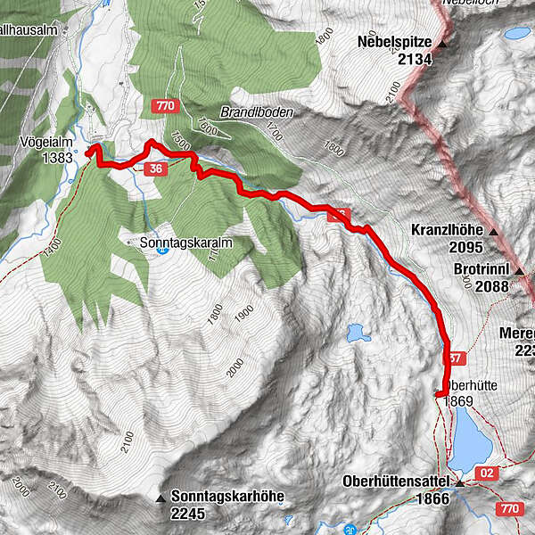
Vögeialm - Oberhütte
Ski resorts
Snow parks
Cross-country skiing
Weather
Webcams
Snow reports
Accommodations
Offers
Sports provider
Events
Summer
Tours
Vögeialm - Oberhütte
Hiking
Bookmark
Map
show
hide
Print
Tour data
2.83
km
1,379 - 1,867
m
Distance
494
hm
6
hm
Ascent
01:18
h
Duration
Henning Kiehn
created am 22.07.2019
2
Views
(Status: unofficial)
Highest point
1,867 m
Report tour
GPS Downloads
GPX
GPS Exchange Format (XML)
KML
Google Earth, Google Maps
QR Download Codes for Mobile Phones
Vögeialm - Oberhütte
QR Codes - tour download for cell phones
GPX
KML
Other tours in the regions
Schladming - Dachstein
3001
Obertauern
1645
Untertauern
504
Popular tours in the area
Salzburger Gipfelspiel: Zum Gerzkopf und zur Schwarzen Lacke
medium
Hiking
8.39
km |
494
hm |
03:45
h
Steirische and Lungauer Kalkspitze summits via Kranzl
difficult
Hiking
10.91
km |
926
hm |
05:10
h
Mosermandl (2680m)
difficult
Hiking
16.34
km |
1442
hm |
06:45
h
Filzmoos: Rötelstein (Rettenstein)
Hiking
9.5
km |
895
hm |
05:00
h
No entries found.
The search is currently not available.
Please refine your search.
Local search results
(<= 25km)
More results
(> 25km)
%count% Search results
%name%
%type%
%elevation%
%population%
%lpButton%