Winter
Summer
Weather
Webcams
Accommodations
Tours
Search history
Search suggestions
No results found
Search
Tours
Home
Summer Österreich
Styria
Tours
schladming -riesach
Ski resorts
Snow parks
Cross-country skiing
Weather
Webcams
Snow reports
Accommodations
Offers
Sports provider
Events
Summer
Tours
schladming -riesach
Hiking
Bookmark
Map
show
hide
Print
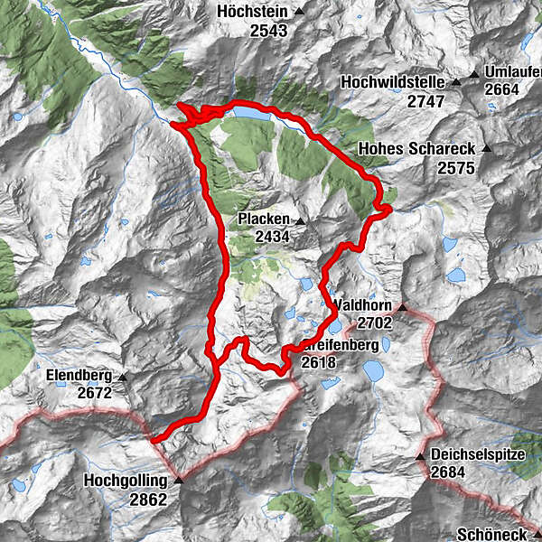
Tour data
28.82
km
1,074 - 2,615
m
Distance
2,784
hm
2,784
hm
Ascent
09:37
h
Duration
Sara Hackl
created am 24.07.2019
1
Views
(Status: unofficial)
Highest point
2,615 m
Report tour
GPS Downloads
GPX
GPS Exchange Format (XML)
KML
Google Earth, Google Maps
QR Download Codes for Mobile Phones
schladming -riesach
QR Codes - tour download for cell phones
GPX
KML
Other tours in the regions
Schladming - Dachstein
3001
Schladming - Rohrmoos
1478
Haus im Ennstal
366
Popular tours in the area
Summit Tour to the Knallstein
medium
Hiking
15.51
km |
1430
hm |
08:00
h
Drei-Seen-Wanderung (Steirischer Bodensee - Hüttensee - Obersee)
medium
Hiking
4.29
km |
591
hm |
04:00
h
Steirische and Lungauer Kalkspitze summits via Kranzl
difficult
Hiking
10.91
km |
926
hm |
05:10
h
Riesach Wasserfälle
Hiking
4.73
km |
292
hm |
03:00
h
No entries found.
The search is currently not available.
Please refine your search.
Local search results
(<= 25km)
More results
(> 25km)
%count% Search results
%name%
%type%
%elevation%
%population%
%lpButton%