Winter
Summer
Weather
Webcams
Accommodations
Tours
Search history
Search suggestions
No results found
Search
Tours
Home
Summer Österreich
Styria
Tours
Duisitzkarhütte
Ski resorts
Snow parks
Cross-country skiing
Weather
Webcams
Snow reports
Accommodations
Offers
Sports provider
Events
Summer
Tours
Duisitzkarhütte
Hiking
Bookmark
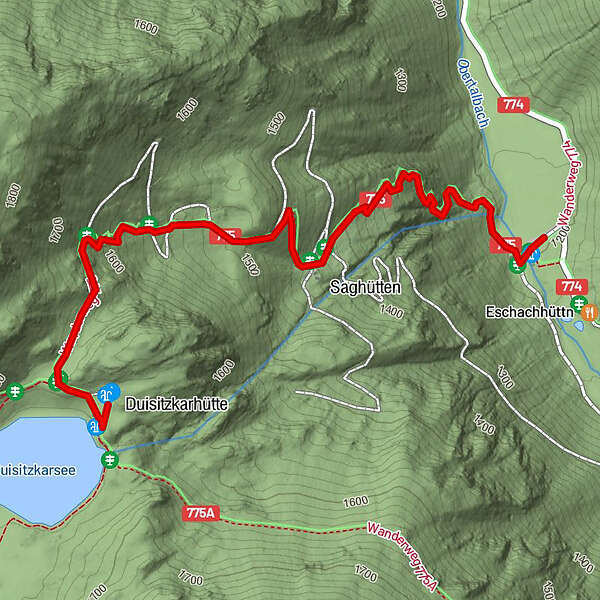
Map
show
hide
Print
Tour data
2.17
km
1,197 - 1,665
m
Distance
482
hm
24
hm
Ascent
-
Duration
Daniel Voß
created am 21.07.2019
3
Views
(Status: unofficial)
Highest point
1,665 m
Report tour
GPS Downloads
GPX
GPS Exchange Format (XML)
KML
Google Earth, Google Maps
QR Download Codes for Mobile Phones
Duisitzkarhütte
QR Codes - tour download for cell phones
GPX
KML
Other tours in the regions
Schladming - Dachstein
2994
Schladming - Rohrmoos
1470
Rohrmoos
512
Popular tours in the area
Höchstein (2.543 m)
difficult
Hiking
11.25
km |
805
hm |
06:00
h
To the Top of the Gröbminger Kammspitze - elev. 2.139 m
difficult
Hiking
11.63
km |
1318
hm |
06:00
h
Filzmoos: Rötelstein (Rettenstein)
Hiking
9.5
km |
895
hm |
05:00
h
Silberkarklamm
medium
Hiking
4.82
km |
329
hm |
03:30
h
No entries found.
The search is currently not available.
Please refine your search.
Local search results
(<= 25km)
More results
(> 25km)
%count% Search results
%name%
%type%
%elevation%
%population%
%lpButton%