- Brief description
-
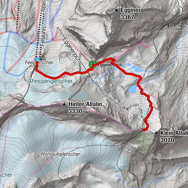
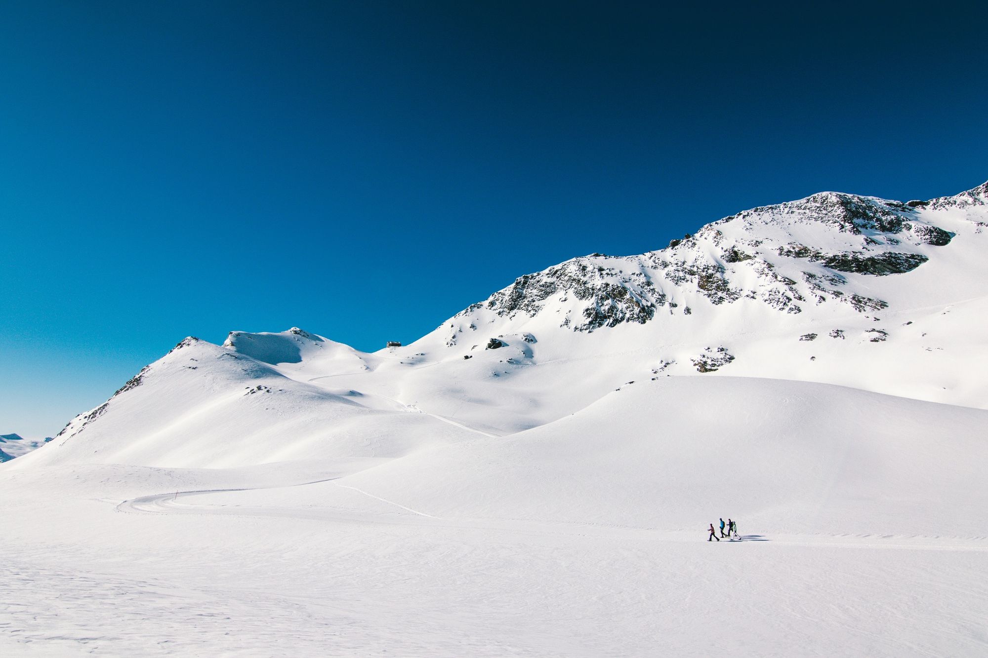
A short, but intense winter hike, set amidst glorious glacial scenery, which leads from the upper Felskinn mountain station to Britannia Hut.
- Difficulty
-
medium
- Rating
-
- Starting point
-
Saas-Fee, Mountain station Felskinn (2988 m)
- Route
-
Felskinn (2,989 m)Britanniahütte (3,030 m)3.0 km
- Best season
-
AugSepOctNovDecJanFebMarAprMayJunJul
- Description
-
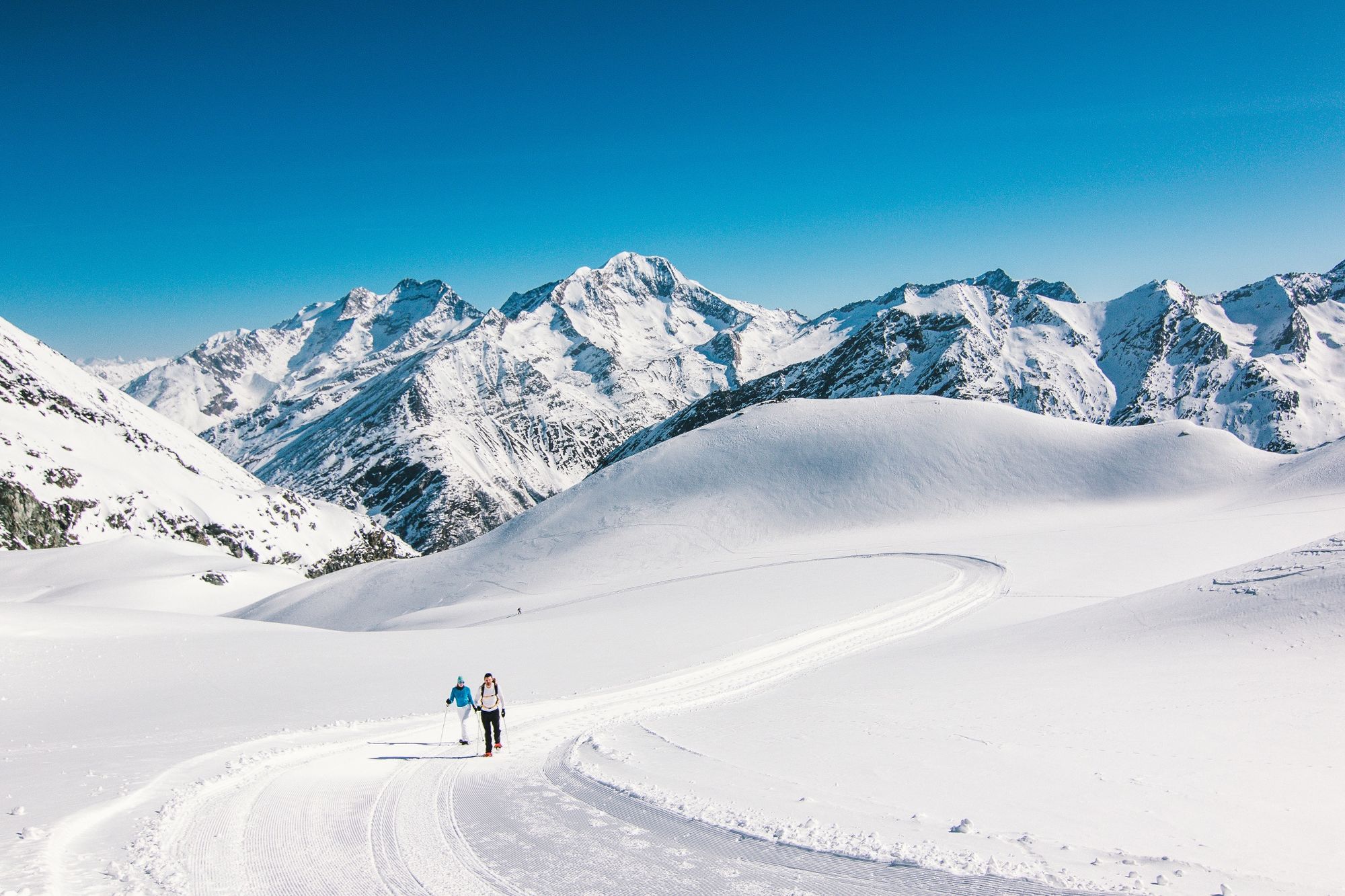
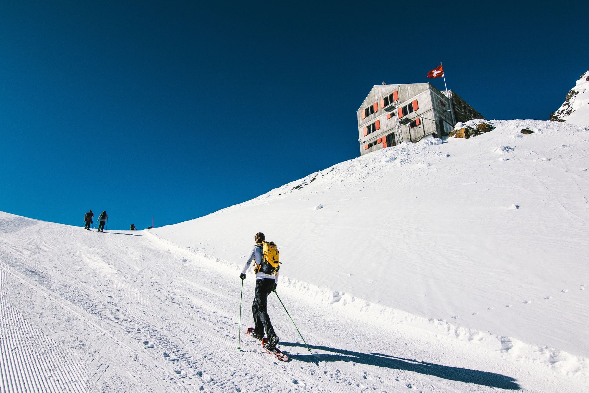
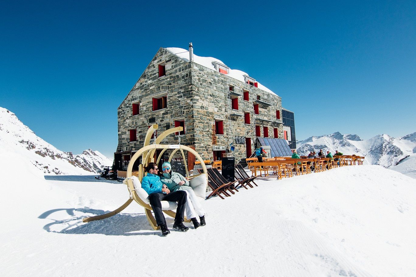
The path leads to the Egginer Pass via the Chessjen glacier. After reaching the top of the pass, take the righthand fork to the south and head for Britannia Hut. Located at 3,030m above sea level, the cabin features an unforgettable view over the Allalin glacier and the Mattmark region and its eponymous dam. First built in 1912, Britannia Hut was completely renovated in 1997 and transformed into a modern hut. It is the most-visited Swiss Alpine Club (SAC) hut in the Alps and the starting point for the famous Haute Route.
This trail is also recomanded as a snowshoe tour.
- Directions
-
The trail starts at the Felskinn mountain station and leads to the Egginer Pass via the Chessjen glacier. After reaching the top of the pass, take the righthand fork to the south and head over the plateau for Britannia Hut.
- Highest point
- 3,024 m
- Endpoint
-
Britannia hut
- Height profile
-
 © outdooractive.com
 - Equipment
-
Use of the trails and the information on this website is at hikers’ own risk. Local conditions may entail changes to routes.
Bring a map. Download full description of this route including large-scale map by clicking on “Print” icon, top right of this page. Use marked trails only, and observe all signposting – for your own safety, to safeguard grazing animals and to avoid disturbing wildlife. Please be considerate to other trail users, and to the plants and animals. Do not leaveanywaste in nature. Take extra care protecting yourself from the sun at altitude. UV radiation can be exceptionally strong, even in cloudy weather. Plan hike carefully: take into consideration fitness level of each participant, weather forecast and season. Weather conditions can change quickly in the mountains, without warning. Appropriate clothing is therefore essential, along with adequate supplies of food and water. In uncertainweather, turn back in good time. Do not venture onto glaciers without a mountain guide. Take note of the warning signs that point out the constant danger, especially the danger of avalanches. Inform others of planned route, and whenever possible, avoid going alone. - Safety instructions
-
Use of the trails and the information on this website is at hikers’ own risk. Local conditions may entail changes to routes.
Use marked trails only, and observe all signposting – for your own safety, to safeguard grazing animals and to avoid disturbing wildlife. Please be considerate to other trail users, and to the plants and animals. Do not leaveanywaste in nature. Take extra care protecting yourself from the sun at altitude. UV radiation can be exceptionally strong, even in cloudy weather. Plan hike carefully: take into consideration fitness level of each participant, weather forecast and season. Weather conditions can change quickly in the mountains, without warning. Appropriate clothing is therefore essential, along with adequate supplies of food and water. In uncertainweather, turn back in good time. Do not venture onto glaciers without a mountain guide. Take note of the warning signs that point out the constant danger, especially the danger of avalanches. Inform others of planned route, and whenever possible, avoid going alone. Pay attention to the opening hours of the cable cars. - Tips
-
Ask at the tourist office or the cableway stations for information on the condition and opening times of this mountain path.
The trail will be prepared at the end of February. - Additional information
-
Saastal Tourismus AG
Obere Dorfstrasse 2
3906 Saas-Fee
Phone: +41 (0)27 958 18 58
E-Mail: info@saas-fee.ch
www.saas-fee.chSaastal Bergbahnen AG
Panoramastrasse 5
3906 Saas-Fee
Phone: +41 (0)27 958 11 00
E-Mail: bergbahnen@saas-fee.ch
www.saas-fee.ch/bergbahnenBritanniahütte SAC
3906 Saas-Fee
Phone: +41 (0)27 957 22 88
E-Mail: info@britannia.ch
www.britannia.chView this tour on SwitzerlandMobility: N°871 Winterwanderweg Britanniahütte
- Directions
-
Saas-Fee/Saastal can easily be reached by car from all directions, whether from Switzerland or abroad. From the north you can reach us via Bern via the Lötschberg car transport. From the east you come over the Furka Pass or the Furka car transport. From the south you can reach us via the Simplon Pass or Simplon car transport and from the west you drive via Lausanne along the Rhône valley to Visp and from there towards Saas-Fee.
From Visp, drive south in the direction of Saas-Fee. At the "Killerhof" roundabout after Stalden, take the second exit towards Saas-Fee. In Saas-Grund, turn right after the church in the direction to Saas-Fee.
- Public transportation
- Parking
- Author
-
The tour Britannia Hut Winter Hiking Trail is used by outdooractive.com provided.


General info
-
Oberwallis
303
-
Saastal
57
-
Saas-Almagell
19