


- Brief description
-
The Dom Hut (2,940 m) is a mountain refuge run by the Swiss Alpine Club (SAC) and equipped with ultra-modern facilities. Its strategic location makes it a popular choice for ascents of seven of the highest mountains in the Alps.
- Difficulty
-
difficult
- Rating
-
- Starting point
-
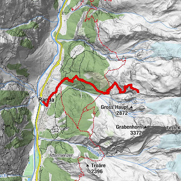
Randa (1,439 m)
- Route
-
Randa (1,406 m)0.0 kmTreff 4940.3 kmKirche St. Sebastian0.3 kmGere1.4 kmDomhütte SAC5.3 km
- Best season
-
JanFebMarAprMayJunJulAugSepOctNovDec
- Description
-
Before hikers can enjoy the welcoming, modern atmosphere of the Dom Hut, they have to conquer a climb of 1,635 vertical metres. This demands a high level of fitness, experience of the mountains and a good head for heights. Parts of the trail are exposed, requiring hikers to make use of metal rungs and safety cables.
The trail requires a good head for heights (metal rungs, safety cables) Fully renovated Dom Hut reopened in 2013 Dormitories with duvets, 1 shower Starting point for ascents of seven 4,000-metre summits including the Dom (4,545 m) Breathtaking view of the Matterhorn on the horizon
In the cabin, new arrivals find themselves in colourfully mixed company – from mountaineers equipped with ropes, crampons and ice axes to mountain walkers who wish simply to enjoy the views in a comfortable setting. - Directions
-
Randa (station) - Lärchberg - Dom hut
(Hiking time for the walk back: approx. 2h 45)
This hike is marked on the signposts as “Domhütte”.
- Highest point
- 2,931 m
- Endpoint
-
Dom Hut (2,940 m)
- Height profile
-
 © outdooractive.com
 - Equipment
-
We recommend:
Good footwear Hiking poles (optional) Clothing suitable for the weather (always carry a waterproof)Important! A good head for heights, a sure foot and mountain experience are needed
- Safety instructions
-
Plan every mountain tour carefully and adapt to participants’ fitness level as well as the weather and season.
Weather conditions can change quickly in the mountains. Appropriate clothing is therefore essential, along with adequate supplies of food and water. In uncertain weather, turn back in good time.
Inform others of planned route, and whenever possible avoid going alone.
Do not leave the marked routes; do not venture onto glaciers without a mountain guide.
Please be considerate to other walkers and to plants and animals.
Take note of the warning signs drawing attention to the constant danger in river beds and along watercourses below dams and reservoirs. - Tips
-
Please contact the Dom Hut for the most up-to-date information on trail conditions.
From the Dom Hut, you can climb the highest peak within Switzerland’s borders (the Dom 4,545 m). Or you can simply enjoy the fantastic panorama in this high Alpine setting. A view of the Matterhorn, Weisshorn, etc.
- Directions
-
The drive from Visp to Randa takes about 30–40 min. The road leads through the wild and beautiful Mattertal valley.
- Public transportation
-
By train to Randa: less than 3½ hours from Zürich airport or 4 hours from Geneva airport. Change at Visp onto the Matterhorn Gotthard Bahn (Matterhorn Gotthard Railway). From Visp, the railway leads through the Mattertal valley past idyllic small villages to Randa.
- Parking
-
There is a public multi-storey car park by the railway station in Randa; simply follow the signs.


- Author
-
The tour Hike to the Dom Hut (Nr. 62) is used by outdooractive.com provided.
General info
-
Oberwallis
1877
-
Mattertal
555
-
Täsch
195


")


