
- Brief description
-
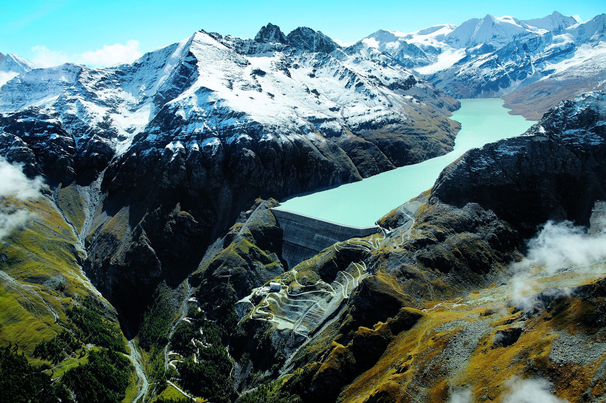
Loop taking in the Grande Dixence dam, the Lac des Dix and a neighbouring valley: fascinating theme trail (hydropower, flora, fauna, geology) with good chances of spotting wildlife.
- Difficulty
-
medium
- Rating
-
- Starting point
-
Grande Dixence dam
- Route
-
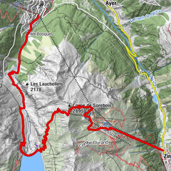
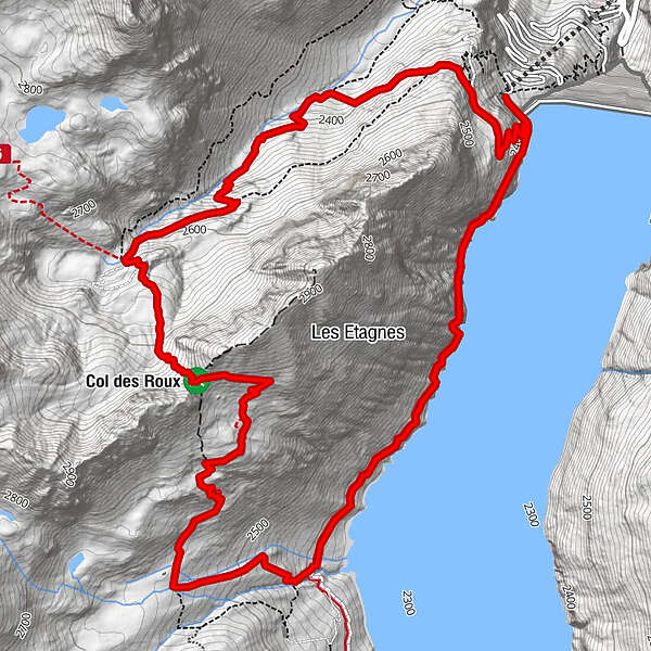
Col des Roux (2,780 m)4.6 kmCol des Roux (2,804 m)4.7 kmCabane de Prafleuri5.4 km
- Best season
-
JanFebMarAprMayJunJulAugSepOctNovDec
- Description
-
Le Sentier des Bouquetins (“The Ibex Trail”) is a theme trail that explores the fauna, flora, history and geology of the Grande Dixence region as it provides an insight into a pioneering hydropower complex. The trail was inaugurated in 2012, and features seven stops – including the Cabane de Prafleuri, ideal for a refreshment break.
Details of the walk appear in an 86-page brochure (available in English, French and German), which can be downloaded free of charge. Printed copies are also for sale at the dam visitor centre (free admission).
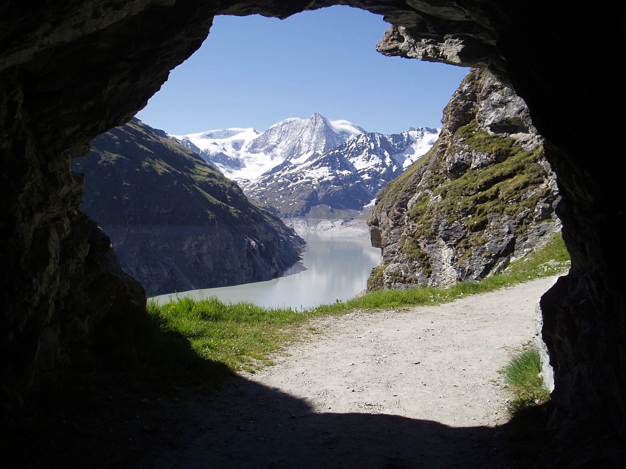
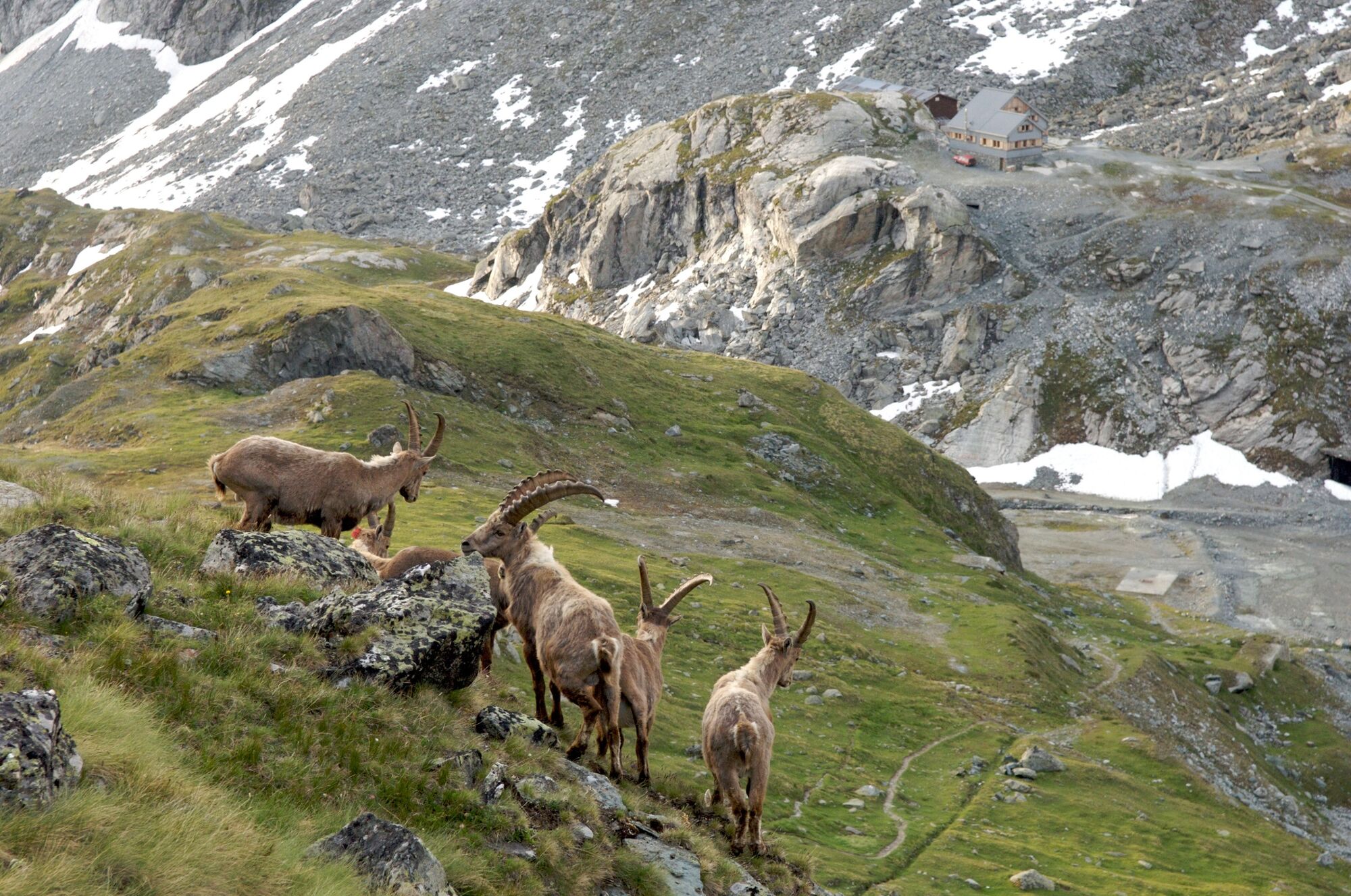
The trail begins near the crest of the dam, and initially leads along the shores of the lake, in and out of a sequence of tunnels. A climb through flower-filled pastures leads to the Col des Roux (2,803 m) and good chances of spotting ibex – the wild cousins of the domestic goat, instantly recognisable with their superb curved horns.
Beyond the col lies a valley, the Combe de Prafleuri, whose glacial moraines provided raw material for the dam in the form of rock crushed into gravel. For 8 years from 1952, about 500 workers lived and slept here in a temporary village of about 20 wooden huts. Just one is left: the only witness of one of the biggest building sites Switzerland has known. The hut previously served as a mountain refuge, but in 2000 a new Cabane de Prafleuri opened a few metres away.
The engineering highlight here is, of course, the dam itself: the tallest in Europe at 285 m. The visitor centre offers guided tours inside the dam, the heart of the Grande Dixence complex: a vast network of reservoirs, underground tunnels, pumping stations and power plants that together form Switzerland’s largest hydroelectric complex.
Highlights
Detailed theme trail on hydropower, wildlife and the history of the dam complex Grande Dixence – world’s largest gravity dam, visitor centre (free admission) and cable car Lac des Dix – path in and out of tunnels along Switzerland’s largest reservoir - Directions
-
The trail begins at the top station of the cable car and leads straight to the crest of the dam. It then follows the western shore of the lake – initially through a sequence of tunnels, then higher up across open meadows – before branching right to climb steadily up to the Col des Roux, the highest point along the circuit (2,803 m). Beyond, the path drops down into the Combe de Prafleuri, soon passing the friendly Cabane de Prafleuri, a handy stop for refreshments. The trail then descends steadily across the flank of the valley before looping around the headland to reveal dramatic views of the lake and dam. A final zig-zag descent leads back to the crest of the dam and the top station of the cable car.
To reach the start of the walk from the foot of the dam (bus stop, visitor centre, hotel, restaurant), either ride up to the crest by cable car or walk up (allow 45 minutes).
- Highest point
- 2,800 m
- Endpoint
-
Grande Dixence dam
- Height profile
-
 © outdooractive.com
 - Equipment
-
We recommend:
good footwear clothing suitable for the weather: always carry a waterproof jacket hat or cap sunscreen bottle for water picnic camera binoculars (optional) hiking poles (optional) printout of this hike (click «Print» icon, to download)For certain walks:
Swimwear - Safety instructions
-
Use of the trails and the information on this website is at hikers’ own risk. Local conditions may entail changes to routes. Valais/Wallis Promotion accepts no liability for the accuracy and completeness of information on this website.
For all hikes:
Bring a map. Download full description of this route including large-scale map by clicking on «Print» icon, top right of this page. Use marked trails only, and observe all signposting – for your own safety, to safeguard grazing animals and to avoid disturbing wildlife. Close gates after passing through. Please be considerate to other trail users, and to the plants and animals. Do not leave any waste in nature.For mountain hikes:
Take extra care protecting yourself from the sun at altitude. UV radiation can be exceptionally strong, even in cloudy weather. Plan hike carefully: take into consideration fitness level of each participant, weather forecast and season. Weather conditions can change quickly in the mountains, without warning. Appropriate clothing is therefore essential, along with adequate supplies of food and water. In uncertain weather, turn back in good time.For high-altitude hikes:
Inform others of the route you plan to take. Whenever possible, avoid going alone. Do not venture onto glaciers without a mountain guide. Take note of the warning signs that point out the constant danger in river beds and along watercourses below dams and reservoirs: water levels may rise rapidly without warning. - Tips
-
Call in at the Grande Dixence visitor centre and join a “sound and light” tour inside the dam, daily from mid-June to September.
- Additional information
- Directions
-
A9 motorway, exit 27 (Sion-Est), follow signs for Vex/Hérémence/Grande Dixence.
- Public transportation
-
Train to Sion, then postal bus to Grande Dixence dam. Find full timetable information at sbb.ch.
- Parking
-
At Grande Dixence.
-

-
AuthorThe tour Sentier des bouquetins is used by outdooractive.com provided.


General info
-
Unterwallis
1196
-
Evolène
650
-
Hérémence
131