

- Brief description
-
If you don't know the Moosalp yet, this hike is the perfect way to get to know it and acclimatize to the altitude of 2,000 metres. The "Stand" is one of the region's beacons. It is the highest point on the high plateau of the Moosalp and offers you an incredible panoramic view of the entire Upper Valais and twelve four-thousand-metre peaks.
- Difficulty
-
easy
- Rating
-
- Starting point
-
Moosalp
- Route
-
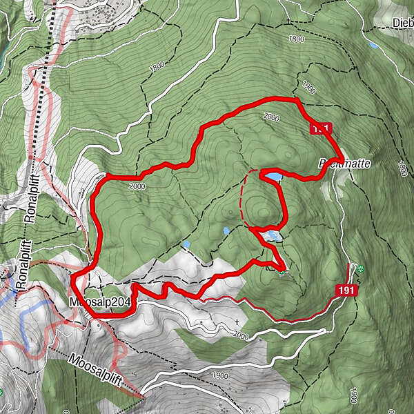
DorbiaMoosalp (2,048 m)0.0 kmStand1.5 kmPanorama5.3 kmDorbia6.2 km
- Best season
-
JanFebMarAprMayJunJulAugSepOctNovDec
- Description
-
The path from the Moosalp to the "Stand" viewpoint leads through a unique nature reserve with typical raised bogs and fens. At Stand, you can enjoy breathtaking views of the Rhone Valley and the fantastic mountain scenery of the Valais and Bernese Alps. The Alpseelein Bonigersee and Breitmattensee lakes along the route are particularly attractive. A multitude of secluded spots and an unimaginably diverse alpine flora allow you to forget everyday life and recharge your batteries.
- Directions
-
The starting and finishing point is Moosalp. From Moosalp, the trail leads past the alpine stables and out into the beautiful natural surroundings of the high plateau. The path is flat, starts wide and then becomes narrower and narrower. There are many ways to get to the first point, the stand. This viewpoint is one of the most visited places on the Moosalp and offers you a wonderful panoramic view of the region. The trail then descends slightly to Lake Boniger. However, this lake is only a real lake at the beginning of summer. After that, the term moor is more appropriate. After Lake Boniger, the trail continues downhill to Lake Breitmatt. This is a small lake that is beautifully situated and makes a perfect photo spot. After Breitmattsee, the route continues downhill to Breitmatte. This is a large clearing in the huge forest area of the Moosalpregion. When you reach the large stone house at Breitmatte, turn left towards Ledi. The trail continues slightly downhill before turning left again at the Ledi point and heading uphill towards Bürchneralp. There, the Panorama mountain restaurant invites you to enjoy a delicious raclette before tackling the last section to Moosalp.
- Highest point
- 2,117 m
- Endpoint
-
Moosalp
- Height profile
-
 © outdooractive.com
 - Equipment
-
Sturdy shoes, provisions and water
- Safety instructions
-
The "Stand" viewpoint is also easy to reach on snowshoes in winter.
- Tips
-
During the summer months, around 150 Hérens and dairy cows are summered on the Moosalp. They are driven into the stables every day at 17:00. A spectacle that you should not miss.
- Additional information
- Directions
-
Guests from the north travel via Bern through the Lötschberg (car transport), from the east and south via the Furka or Simplon Pass (or car transport). From the west, you can reach the Moosalp region via Lausanne, along the Rhone Valley to Turtmann, Visp. The Moosalp can be reached from Visp via Bürchen or via Stalden-Törbel.
- Public transportation
-
Bus connections: Visp - Bürchen - Moosalp | Visp - Stalden - Törbel - Moosalp
- Parking
-
There is a parking lot.
- Author
-
The tour Panoramaweg Stand (Moosalp) is used by outdooractive.com provided.


General info
-
Oberwallis
1873
-
Unterbäch
934
-
Törbel
150


