
- Brief description
-
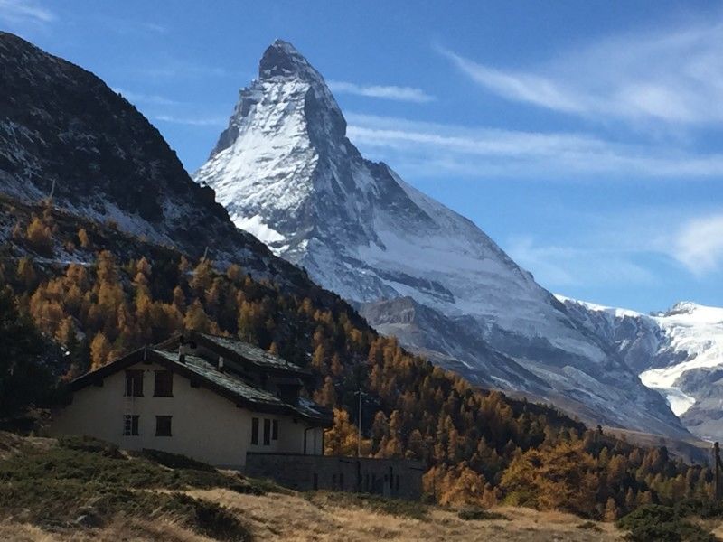
Enjoy an exceptional view of the Matterhorn from this loop which combines a particularly steep start with a long singletrack above the Zermatt valley.
- Difficulty
-
difficult
- Rating
-
- Starting point
-
Zermatt
- Route
-
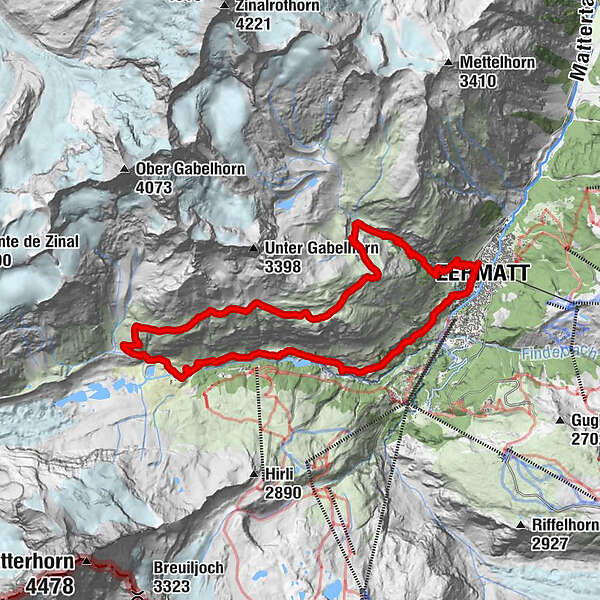
Zermatt (1,608 m)0.0 kmBerggasthaus Trift (2,337 m)3.8 kmZmuttbachfall11.6 kmRestaurant Jägerstube16.2 kmZmutt16.2 kmKirche St. Mauritius19.4 kmZermatt (1,608 m)19.7 km
- Best season
-
JanFebMarAprMayJunJulAugSepOctNovDec
- Description
-
Starting from Zermatt, follow one of the Edelweissweg or Höhbalmen marked trails. The route begins with a demanding ascent through the gorge to Trift. After this point, continue on a slope that gradually becomes gentler as you approach Höhbalmen and look out over the Matterhorn to the other side of the valley. Continue on a fairly smooth single track that runs along the hillside, then go down along the Arbenbach waterfalls before turning in the direction of Zmutt. When going through this small village, take the path overlooking the valley to make your way back to Zermatt. Cross green pastures and meander through larch forests before reaching the village of Zermatt.
- Directions
-
From Zermatt, a steep trail leads to the Restaurant Edelweiss and continues up to Trift. The path to Höhbalmen runs along the hillside, high above the length of the valley with incredible views of the Matterhorn. Next drop down to Zmutt and continue to where you started in Zermatt.
Zermatt - Restaurant Edelweiss - Trift - Höhbalmen - Zmutt - Zermatt
- Highest point
- 2,742 m
- Endpoint
-
Zermatt
- Height profile
-
 © outdooractive.com
 - Equipment
-
We recommend:
Good footwear Weather-appropriate clothing: always carry a waterproof jacket Hat or peak cap Sunscreen Water bottle Hiking poles - Safety instructions
-
Use of the trails and the information on this website is at your own risk. Local conditions may entail changes to routes. Valais/Wallis Promotion accepts no liability for the accuracy and completeness of information on this website.
For all trails:
Use marked trails only, and take note of all signposting – for both your own safety as well as that of grazing animals and to avoid disturbing wildlife. Close gates after passing through. Please treat other trail users, as well as the plants and animals, with respect.For mountain trails:
Take extra care protecting yourself from the sun at high altitudes. UV radiation can be exceptionally strong, even in cloudy weather. Plan your trail carefully: take the fitness level of each participant, weather forecast and season into consideration. Weather conditions can change quickly in the mountains, without warning. Appropriate clothing is therefore essential, along with adequate supplies of food and water. In case of uncertain weather conditions, turn back in good time. Inform others of the route you plan to take. Whenever possible, avoid going alone. Take note of warning signs indicating the constant danger in river beds and along watercourses below dams and reservoirs: water levels may rise rapidly without warning. - Tips
-
Take a seat for a moment on the little bench in Höhbalmen and enjoy the view.
- Additional information
- Directions
-
From Visp, follow the Talstrasse to Täsch, where a shuttle train will take you to Zermatt, as the village is closed to traffic.
- Public transportation
-
Take the train to Visp station, followed by the Glacier Express to Zermatt.
- Parking
-
Parking is available in Täsch at the train station.


- Author
-
The tour Zermatt Höhbalmen Loop is used by outdooractive.com provided.


General info
-
Oberwallis
114
-
Mattertal
34
-
Zermatt
14