- Brief description
-
A demanding climb from the valley bottom to the Bavon ridge!
- Difficulty
-
medium
- Rating
-
- Starting point
-
Village of Dranse
- Route
-
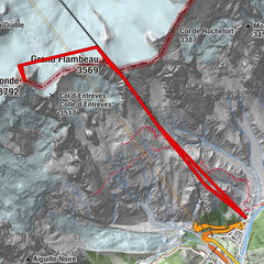
Café de DranseDranse (Liddes)0.1 kmLe Tomeley (1,718 m)1.6 km
- Best season
-
AugSepOctNovDecJanFebMarAprMayJunJul
- Description
-
From the hamlet of Dranse, you will pass at the entrance to the Combe de l'A before joining the blue course n°1 and then the red course n°2.
- Directions
-
From Dranse, go up through the meadows to reach the forest at the place called Tommelley before passing by the entrance to the Combe de l'A.
Then come back north to join the blue course and then west to join the red course. Follow it south to La Chaux before crossing the ski area north to the snow bar.
- Highest point
- 2,020 m
- Endpoint
-
Village of Dranse
- Height profile
-
 © outdooractive.com
 - Equipment
-
You can hire all the necessary equipment from Cristal Sport in Orsières.
- Safety instructions
-
• Movement Tracks can only be used by people who have the technique, physical condition and equipment required for ski touring, including emergency equipment. Please stay on the marked route to avoid avalanches dangers.
• Each hiker ascends and descends at his/her own risk and under his/her own responsibility. Every hiker is subject to the FIS rules and must respect the SKUS guidelines (Swiss commission for the prevention of accidents on downhill Skiing)
• Outside of opening hours, the slopes and runs are closed and cannot be used. Presence of tamping machines with traction cables - danger of death! Only the resort and the persons in charge of the safety of the ski lifts and snow groomers can open the slopes and descents to touring skiers.
• Do not leave any garbage behind, respect nature and the owners of the land used. The forest is a quiet zone for wildlife, stay on the trails.
• The local Tourist Office of Liddes declines all responsibility in case of accident.
- Tips
-
Take advantage of the "Bar des Neiges" to have a bite to eat before going back down!
- Additional information
- Directions
-
Leave the highway at Martigny.
Follow the direction Grand-Saint-Bernard until Liddes.
Turn right after the tourist office to go down to Dranse.
- Public transportation
- Parking
-
Free parking next to the soccer field
- Author
-
The tour Rando-parc "Vichères Movement tracks": Dranse - Vouardette is used by outdooractive.com provided.