


- Brief description
-
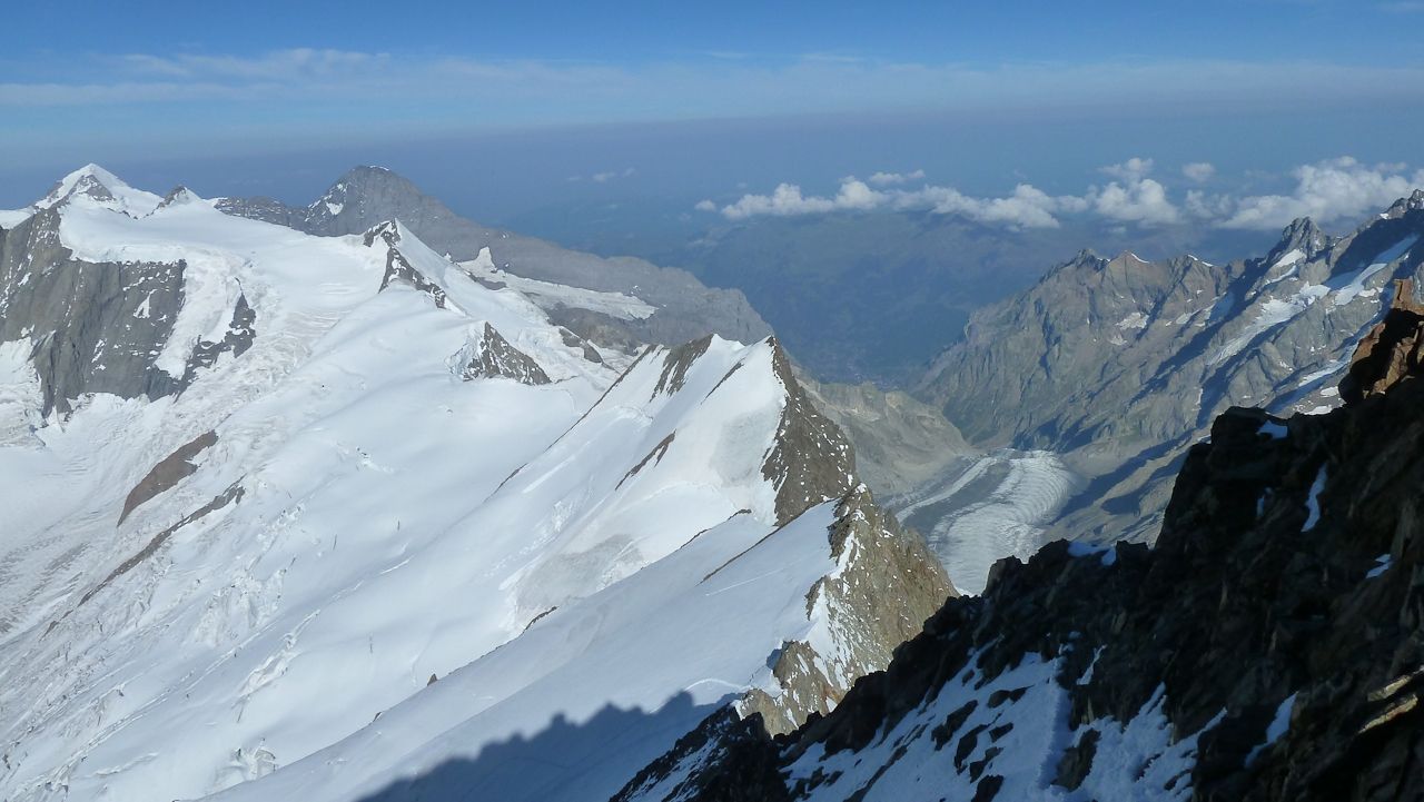
Finsteraarhorn is the highest peak of the canton Bernese Oberland and the third most prominent peak in the Alps. It has the shape of a steep, majestic pyramid, rising from a web of glaciers. And it is one of the most beautiful mountains in the entire Switzerland.
Despite its superior height, its northwestern neighbors Jungfrau (4158m), Mönch (4099m), and Eiger (3970m) are more famous, owing in part to Eiger's towering north face, in part to the tourism that has built up around them.
- Difficulty
-
medium
- Rating
-
- Starting point
-
Finsteraarhorn Hut
- Route
-
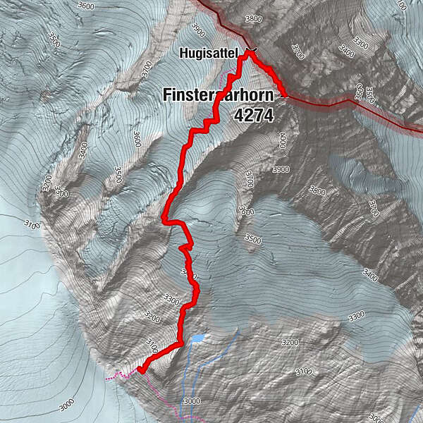
Hugisattel3.3 kmFinsteraarhorn (4,274 m)3.8 km
- Best season
-
JanFebMarAprMayJunJulAugSepOctNovDec
- Description
-
Team Germany climbed the Finsteraarhorn on September, 10th, 2012, during the Mammut Peak Project:
Our team already had spent 3 days in the Bernese Oberland getting together, doing some acclimatizaton tours etc. when finally the day for our "150 peak project" summit had come. Originally we had planned to climb the Gross Grünhorn. Bue due to some unforseen changes in the weather conditions we decided at short notice and by reasons of security to climb Finsteraarhorn instead.
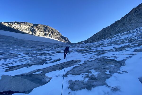
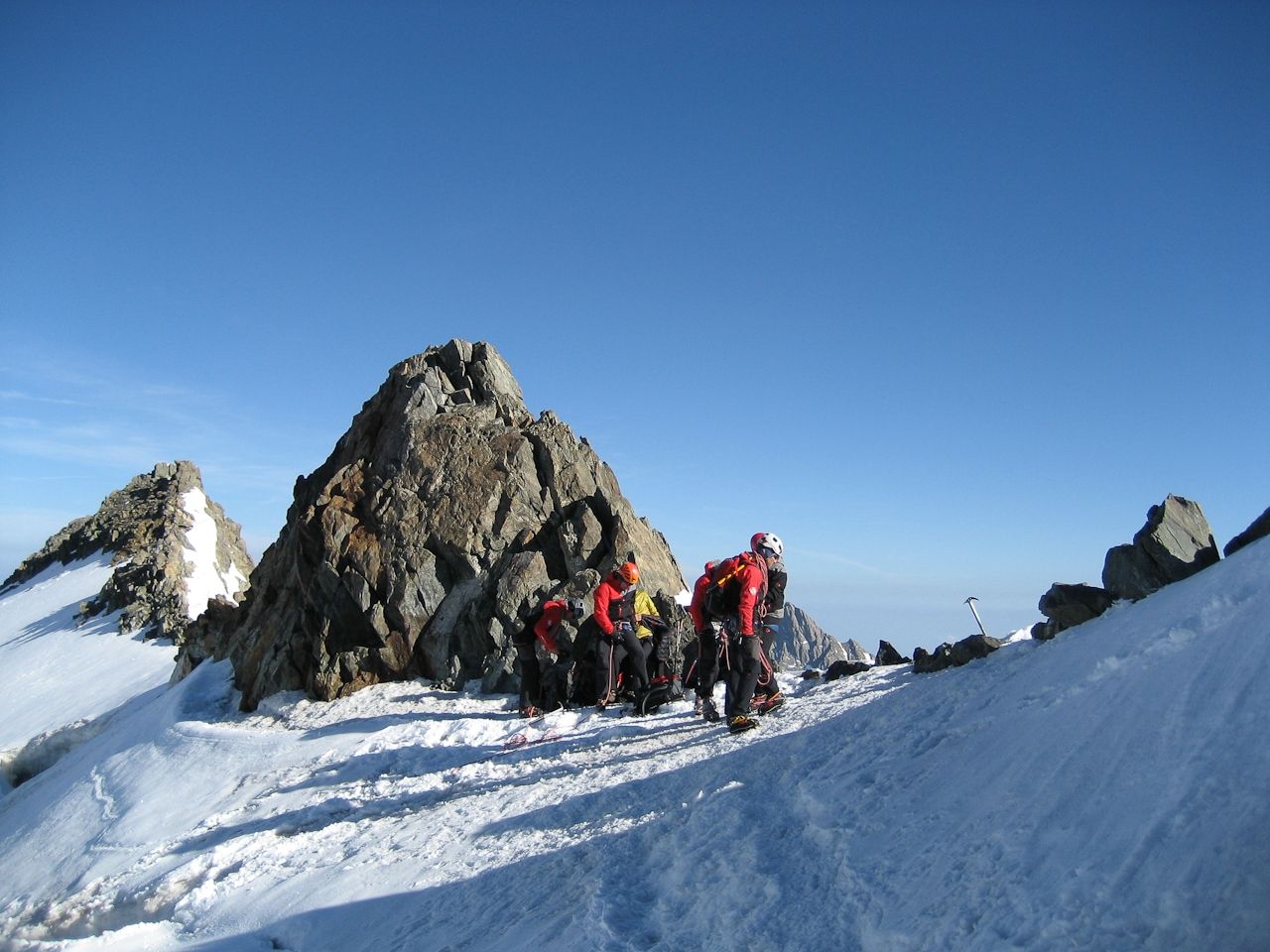
So bang on time at 6 clock we left Finsteraarhorn hut. At first we thought to be alone on the track, but durning a short stop where we put on our crampons, we realized that we were followd by a solo-mountaineer, which in the following also took over and passed our group. Our mountain guides named him "Missing aspirant" (In their mind they probably already saw his picture hanging at the lunch counters of the huts in the coming months).
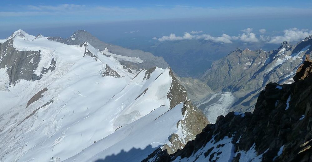
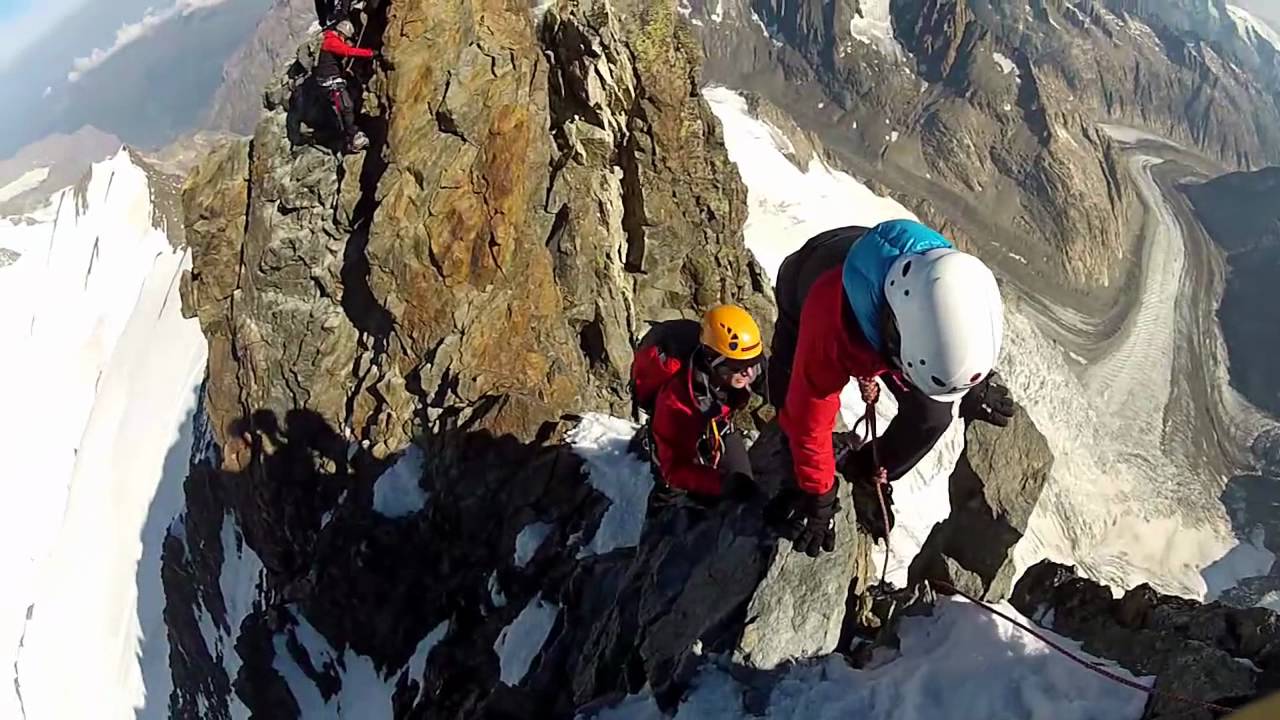
Being surrounded by a beautiful panorama all the time, our three roped parties reached the Hugisattel (4.088m) without problems. After a short break we started the last 300m to the summit. Climbing the northwest ridge was breathtalking and pure fun. Keeping on the crampons proved to be a correct decision. The weather was at its best. Sun, blue sky, absolutely calm and a beautful panorama of Eiger, Monch and Jungfrau let us have a perfect rest on the summit. Luckily the "Missing aspirant" was still at the summit, so he could take a lot of pictures of our team wearing our Mammut Peak Collection. Unfortunately we were missing one team member who had decided to wait at the Hugisattel due to slight signs of altitude sickness.
Back from the summit, on the descent of the glacier, some snow bridges already were found to be unstable and forced us to make some detours. But the whole group arrived safe at the Finsteraarhorn hut. Back at the hut we enjoyed a good portion "Finsteraarhornrösti" (highly recommended ☺) and thoroughly happy we looked back on a perfect day in the mountains.
- Directions
-
The normal route to the summit leads from Finsteraarhornhut and the Hugisattel.
From the Finsteraarhorn hut ( 3048 m) climb the steep slope behind the hut. At 3.616 m turn left and cross the rocky ridge that comes down from the summit. This place is called Frühstücksplatz (breakfast place). On the other side of ridge keep in the middle of the funnel that leads up the Hugisattel (4094 m), this is the saddle next to the summit. Hard snow or ice, but few and harmless crevasses. From Hugisattel on easy rock to the summit, first on the west side, then keep always on the ridge. It's recommend to climb with crampons on since there may be icy sections even in summer.
- Highest point
- 4,078 m
- Endpoint
-
Finsteraarhorn
- Height profile
-
 © outdooractive.com
 - Equipment
-
Since it's an alpine tour that leads above 4.000m you'll need appropriate equipment. Besides boots and clothing for alpine touring make sure that you have the following gear (and that you know how to use it!):
Climbing harness, 2 HMS Karabiners, 3 Allcord, Ice screw, Single rope, Crampons, Ice axe, Drink bottle, Bivouac sac, Headlamp, Suncream, Two-chamber gloves, Cap, First aid-kit, Rucksack, Sunglasses, Energy bars, Mountaineering poles, Gaiters, Personal medicaments, ...
- Additional information
-
Finsteraarhorn Hut: http://finsteraarhornhuette.ch/
Finsteraarhorn at SummitPost: http://www.summitpost.org/finsteraarhorn/150587
Finsteraahorn at Wikipedia: http://en.wikipedia.org/wiki/FinsteraarhornFinsteraarhorn hut:
Coordinates: 651'860 / 152'520
Height: 3048 m asl
Maps: 1:25 000 1249 "Finsteraarhorn", 1250 "Ulrichen"; 1:50 '000 264 "virgin", 265 "Nufenenpass"
Alpine Tours Jungfrau Region 2010
Club leaders SAC: Bernese Alps IV & V - Directions
-
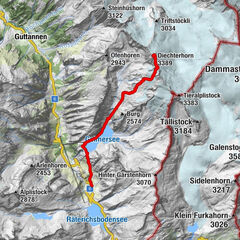
Starting point for climbing the Finsteraarhorn on the normal route is the Finsteraarhorn Hut which is is located in the Bernese Alps, at the southwestern foot of the Finsteraarhorn, a few meters above Fieschergletscher (second longest glacier in the Alps). Since 2001 the whole massif and surrounding glaciers are part of the Jungfrau-Aletsch World Heritage Site.
The hut was completely rebuilt in 2003 and is administered by the SAC section Oberhasli. It has 106 places for sleeping and eating and is a very comfortable hut. Maybe even a bit too luxurious for old-school alpinists. But that is a matter of personal taste. The dining room is very cozy and there is a large sun terrace where you can enjoy a beatiful view. Toilets are very clean, as is the hut in general. In the summer there's also enough running water for washing.
How to get there :
Access to Finsteraarhornhütte is long in any case, and leads over glaciers. The least access time is one of the Jungfraujoch ago. From the south, the route from Fiescheralp the Great Aletsch glacier and the Grünhornlücke opened in 2009, and the route of Bellwald are possible. From the east, the hut from the Oberaarsee be achieved. A popular access leads from the Mönchsjochhütte about the Big Fiescherhorn (Walchergrat) or via the Fieschersattel (see details Alpine Tours Jungfrau Region, SAC Verlag, 2010).
- From Jungfraujoch station: F. 6-6½ h (and 7-8 h for the opposite direction)
- From Lake Oberaar: 7–8 h. (6–7 h for the opposite direction). Taking the route via via Gemschlicke is not recommended anymore (falling stones/rocks)
- From Fiescheralp: 8-9 h
For detailled info and actual conditions check the Finsteraarhorn huts homepage.
- Public transportation
-
When approaching Finsteraarhorn hut from Jungfrau Joch (the highest railway station in Europe) you can take the Jungfrau Bahn from Grindelwald that runs within a tunnel built into the Eiger and Mönch mountains and contains two stations in the middle of the tunnel, where passengers can disembark to observe the neighbouring mountains through windows built into the mountainside. Unfortunately the tickets are quite expensive (90 Swiss Franks in 2012).
To get to Grimselpass you can take the famous Swiss Postbus (line/route 161 Meiringen – Grimsel – Oberwald). Check PostBus homepage for timetable and costs.
Starting from Fiesch you can reach Fiescheralp by Fiescheralp-Eggishorn cable car. For timetable and prices check their homepage.In general you can say that public transport in Switzerland is one of the best in Europe. Taxi, Bus, Postbus, Train, Cable Car etc. are very well connected and you can reach nearly every point by public transport within short time.
- Parking
-
There are public parking places (could be expensive!) in Grindelwald and Fiesch. Parking at the Oberaar Lake (Grimselpass) is not possible. Since the public transport in Switzerland is very well organized (and also for ecological reasons) you should consider taking bus or train to get to your starting point.


-

-
AuthorMammutThe tour Finsteraarhorn 4.274m (normal route) is used by outdooractive.com provided.


General info
-
Aletsch Arena
38
-
Jungfrau Region
23