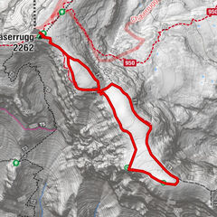
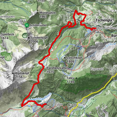
Tour data
2.65km
438 - 445m
Distance
4hm
7hm
Ascent
00:39h
 
Duration
Brief description

Walking

Difficulty
easy
Rating
Technique
Fitness
Landscape
Experience
Route
Feldkirch
0.6 km

Highest point
445 m

Overall rating

5

0

%

4

0

%

3

0

%

2

0

%

1

0

%

Error
An error has occurred. Please try again.
Thank you for your review

Rating has been deleted

GPS Downloads
  • GPX GPS Exchange Format (XML)
  • KML Google Earth, Google Maps
QR Download Codes for Mobile Phones
Other tours in the regions

Popular tours in the area

High altitude hiking trail | Brand

medium Winter hiking
4.77km | 180hm | 02:00h

Stump's Laternliweg am Schwendisee

easy Winter hiking
1.33km | 9hm | 00:20h

Winterwandern auf dem Rosenboden Panoramarundweg

easy Winter hiking
2.95km | 90hm | 01:10h

Alte Statt Weg | Brandnertal

medium Winter hiking
9.86km | 243hm | 03:30h