Dem Illweg entlang

Logo Dem Illweg entlang
Tour data
5.93km
662 - 697m
Distance
40hm
47hm
Ascent
01:30h
 
Duration
Brief description

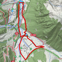
Ortszentrum Tschagguns - A.-Jochum-Weg - Illweg - Aktivpark Montafon - Bödmenstein Steg - Illweg - Parkplatz Aktivpark Montafon - Illweg - A.-Jochum-Weg - Ortszentrum Tschagguns

Difficulty
easy
Rating
Technique
Fitness
Landscape
Experience
Route
Tschagguns
0.2 km
In der Au
0.2 km
Tschagguns
5.7 km

Best season
Aug
Sep
Oct
Nov
Dec
Jan
Feb
Mar
Apr
May
Jun
Jul
Highest point
697 m
Endpoint

Ortszentrum Tschagguns

Height profile

Author
The tour Dem Illweg entlang is used by outdooractive.com provided.

Overall rating

5

0

%

4

0

%

3

0

%

2

0

%

1

0

%

Error
An error has occurred. Please try again.
Thank you for your review

Rating has been deleted

GPS Downloads
  • GPX GPS Exchange Format (XML)
  • KML Google Earth, Google Maps
QR Download Codes for Mobile Phones

General info

Refreshment stop
Other tours in the regions

Popular tours in the area

Vergaldner Rundwanderweg

medium Winter hiking
3.31km | 149hm | 01:15h

SnowflakesPanoramaTrail Rüfikopf

easy Winter hiking
2.74km | 90hm | 01:30h

Alte Statt Weg | Brandnertal

medium Winter hiking
9.86km | 243hm | 03:30h

Lech - Zug

easy Winter hiking
6.96km | 108hm | 00:30h