
- Brief description
-
Gentle ramble at altitudes above 1,600 m on prepared hiking paths.
- Difficulty
-
easy
- Rating
-
- Starting point
-
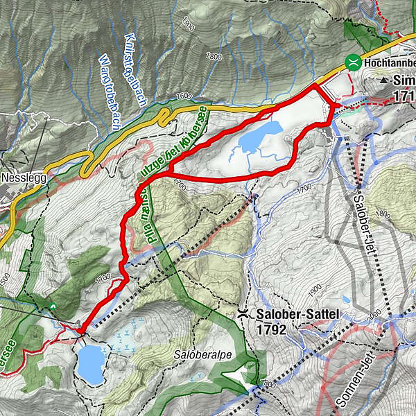
Hochtannberg pass
- Route
-
SB-Restaurant Salober4.9 kmKörblliftle5.0 kmAlpekörb5.0 km
- Best season
-
AugSepOctNovDecJanFebMarAprMayJunJul
- Description
-
From the Hochtannberg pass (1,676 m), you follow the hiking path close to the road (take the right path for the circuit), pas the Körber cross and take a considerable hike up to the Witelesattel (1,750 m) and then down to the Hotel Körbersee (1,665 m). If the snow conditions are good, it is worth following this up by taking another walk around the frozen Körbersee. If you take the right piste on the way back too, you will enjoy a circuit via various path.
- Directions
-
From the Hochtannberg pass (1,676 m), you follow the hiking path close to the road (take the right path for the circuit), pas the Körber cross and take a considerable hike up to the Witelesattel (1,750 m) and then down to the Hotel Körbersee (1,665 m). If the snow conditions are good, it is worth following this up by taking another walk around the frozen Körbersee. If you take the right piste on the way back too, you will enjoy a circuit via various path.
- Highest point
- 1,741 m
- Endpoint
-
Hochtannberg pass
- Height profile
-

- Equipment
-
- waterproof footwear
- warm outerwear - Safety instructions
- Tips
-
A drink/food:
Valley station of the Saloberkopf cable car, Hotel Körbersee - Directions
-
From Germany:
Motorway Lindau, Pfänder Tunnel, Exit Dornbirn Nord - Bregenzerwald - Egg - Mellau - Au - Schröcken
Motorway Kempten - Immenstadt - Oberstaufen - border crossing Springen-Aach - Lingenau - Egg - Au - Schröcken
Garmisch-Partenkirchen or Füssen - Reutte (Tirol) - Lechtal - Warth - Schröcken
From Switzerland:
Motorway St. Gallen - St. Margrethen/Au - Lustenau - Dornbirn - Bregenzerwald - Egg - Mellau - Au - Schröcken.
From Austria:
Inntal-Motorway - Innsbruck - St. Anton - Arlbergpaß - Lech - Warth (at winter closure Arlbergtunnel - Dornbirn) - Schröcken - Public transportation
- Parking
-
Parking at the valley station of the Saloberkopf cable car

- Author
-
The tour Schröcken | to the hotel at the lake is used by outdooractive.com provided.