- Brief description
-
A leisurely walk from Zug to the fishpond, along the cross-country trail and back clockwise to the Zuger Kirchle.
- Difficulty
-
easy
- Rating
-
- Starting point
-
Bus stop Zug
- Route
-
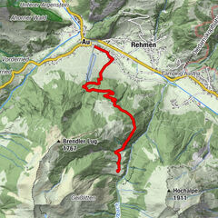
SebastianskircheZug2.9 km
- Best season
-
AugSepOctNovDecJanFebMarAprMayJunJul
- Description
-
The tour starts at the bus stop in Zug, at the famous Kirchle. From here, follow the marked path downhill towards Lech. The idyllic winter hiking trail runs along the cross-country skiing trail. An ideal walk for families with children. Soon the path branches off to the right uphill. The first passage is somewhat steeper, then the path continues without major ascents or descents. Cross the road and follow the signs clockwise back to the starting point of the hike. After the hike it is worth stopping at a restaurant and warming up with warm drinks.
- Directions
-
The tour starts at the bus stop in Zug, at the famous Kirchle. From here, follow the marked path downhill towards Lech. The idyllic winter hiking trail runs along the cross-country skiing trail. An ideal walk for families with children. Soon the path branches off to the right uphill. The first passage is somewhat steeper, then the path continues without major ascents or descents. Cross the road and follow the signs clockwise back to the starting point of the hike. After the hike it is worth stopping at a restaurant and warming up with warm drinks.
- Highest point
- 1,559 m
- Endpoint
-
Bus stop Zug
- Height profile
-

- Equipment
-
Good winter shoes, warm clothes, cap, scarf, gloves
- Safety instructions
-
EMERGENCY CALL:
140 Alpine Emergencies Austria-wide
144 Alpine Emergencies Vorarlberg
112 Euo emergency call (works with any mobile phone/network)
www.vorarlberg.travel/sicherheitstipps
- Tips
-
The restaurant by the restaurant Fischteich is open in summer and is known for its fish specialities far beyond Lech.
- Additional information
- Directions
-
From Germany: Take the A 96 to Bregenz from there on the A14 to Bludenz, continue on the S16 to the Lech Zürs am Arlberg exit. Follow the B197 to Alpe Rauz, turn left here onto the B198. Through the Flexengalerie and over the Flexenpass you reach Lech Zürs am Arlberg.
From Switzerland: Via the A13 and the Feldkirch, Hohenems or Lustenau border crossing onto the A14 as far as Bludenz. Continue on the S16 to the Lech Zürs am Arlberg exit. Follow the B197 to Alpe Rauz, turn left here onto the B198. Through the Flexengalerie and over the Flexenpass you reach Lech Zürs am Arlberg.
From Austria: Take the Inntal motorway A12 and then the S16 to the St. Anton am Arlberg exit (Arlbergpass). Follow the B197 first through St. Anton, then through St. Christoph and over the Arlberg Pass to Alpe Rauz. Turn right here onto the B198. Through the Flexengalerie and over the Flexenpass you reach Lech Zürs am Arlberg.
- Public transportation
-
Take the train to Langen am Arlberg or St. Anton am Arlberg station. From there, buses (Nr. 750+760) run at regular intervals to Lech Zürs am Arlberg.
- Parking
-
You can park your car either directly with your host or in the underground car park Anger. The underground car park is located directly in the town centre opposite the Raiffeisenbank Lech.
-

-
AuthorThe tour Zuger Runde is used by outdooractive.com provided.