


- Brief description
-
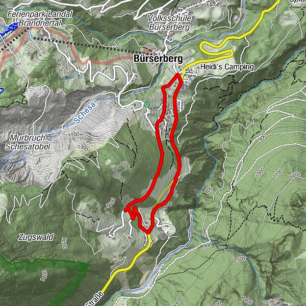
This trail leads you from the center in Bürserberg via the Zugs parcel in a beautiful circular tour back to the starting point.
- Difficulty
-
easy
- Rating
-
- Starting point
-
Municipal office, Bürserberg
- Route
-
Kapelle zu Unserer Lieben Frau1.3 kmBürserberg3.3 km
- Best season
-
JanFebMarAprMayJunJulAugSepOctNovDec
- Description
-
From the Bürserberg municipal office, follow the main road in the direction of Brand. When you reach the tunnel, walk past it on the left. After the tunnel, follow the road for about 100 m and then turn right. From here the trail goes uphill in the direction of the Zugs parcel. At the bee house, follow the hiking trail to the right. At the end of this path you will come back to Tschenglastraße and return to the starting point via this road.
- Directions
-
Bürserberg municipal office - main road towards Brand - tunnel - pass the tunnel on the left - turn off towards Parzelle Zugs - Parzelle Zugs - hiking trail - Tschenlgastraße - Bürserberg municipal office
- Highest point
- 990 m
- Endpoint
-
Municipal office, Bürserberg
- Height profile
-

- Equipment
-
Sturdy shoes, rain and sun protection, snack, filled water bottle and hiking poles are recommended. Mobile phone in case of emergency.
- Safety instructions
- Tips
-
If you want to extend this tour, you can hike from the Zugs parcel to the Burtscha Alpe - a steep but very beautiful hiking trail.
- Directions
-
maps.google.at
- Public transportation
- Parking
-
Municipal office, Bürserberg

- Author
-
The tour Bürserberg circular trail via Zugs parcel | Bürserberg is used by outdooractive.com provided.


-
Appenzellerland
1955
-
Brandnertal
1567
-
Bürserberg
483


