
- Brief description
-
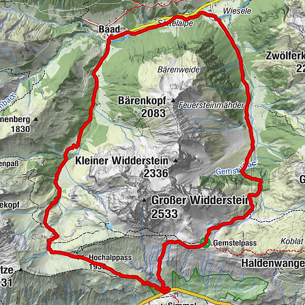
The tour starts at the Hochtannbergpass at an altitude of 1,676 m. The trail leads between wild flowers and fresh alpine herbs towards the Hochalppass. From here, follow the path to the Bärgunt-Hütte and continue to the village of Baad in the Kleinwalsertal. At the right turn, a path leads to the beginning of Mittelberg. Passing the Gemstelboden, the hiking trail takes you to the next hut – to Bernhard’s Gemstelalpe. Follow the path towards Widdersteinhütte and descend again to the Hochtannbergpass.
- Difficulty
-
difficult
- Rating
-
- Starting point
-
Hochtannbergpass
- Route
-
Hochalppass (1,938 m)1.8 kmBärgunt-Hütte (1,408 m)4.8 kmRestaurant Kuhstall7.1 kmBaad (1,244 m)7.1 kmBernhards Gemstelalpe10.9 kmHintere Gemstelalpe11.6 kmKlamm12.5 kmAlpwirtschaft Obere Gemstelalpe13.2 kmWiddersteinhütte14.9 km
- Best season
-
JanFebMarAprMayJunJulAugSepOctNovDec
- Description
-
Touring.
Hochtannbergpass - Hochalppass - Bärgunt-Hütte - Baad - Mittalberg - Gemstelboden - Bernhards Gemstelalpe - Widdersteinhütte - Hochtannbergpass
- Directions
-
Touring.
Hochtannbergpass - Hochalppass - Bärgunt-Hütte - Baad - Mittalberg - Gemstelboden - Bernhards Gemstelalpe - Widdersteinhütte - Hochtannbergpass
- Highest point
- 2,003 m
- Endpoint
-
Hochtannbergpass
- Height profile
-

- Equipment
-
This should never be missing on the mountain.
Backpack, First-Aid Set incl. Bladder plaster, telephone with emergency number, cash, drinking bottle, pocket knife, provisions, sun protection in good weather.
- Safety instructions
-
Emergency numbers.
140 - Alpine emergencies throughout Austria
144 - Alpine emergencies in Vorarlberg
112 - Euro emergency call
- Additional information
- Directions
- Public transportation
- Parking


-

-
AuthorThe tour Around the Widderstein is used by outdooractive.com provided.