
- Brief description
-
At the Seven Summits Weekend, condition-strong hikers, but also trail runners, will get their money’s worth. The challenging 2-day tour has it in itself, because the seven summits have to be worked hard on long stages. On the programme on day 1: A total of 32 km of route, for which good 16 hours of walking should be planned at normal walking speed. Four beautiful peaks are celebrated on this dream tour. You spend the night relaxing in the valley before going on the other three mountains in the second part of the tour. Here, the 28-kilometre hike is expected to take about 13 1⁄2 hours. Especially for ambitious trail runners, the Seven Summits Weekend is a challenge with many scenic highlights and varied trails.
Stage 1: Hochkünzelspitze – Rothorn – Hochberg – Braunarlspitze (walking time: 16 hours)
Stage 2: Peanut Flow – Juppenspitze – Höferspitze (Time: 13 1⁄2 hours)
- Difficulty
-
difficult
- Rating
-
- Starting point
-
Schröcken village square
- Route
-
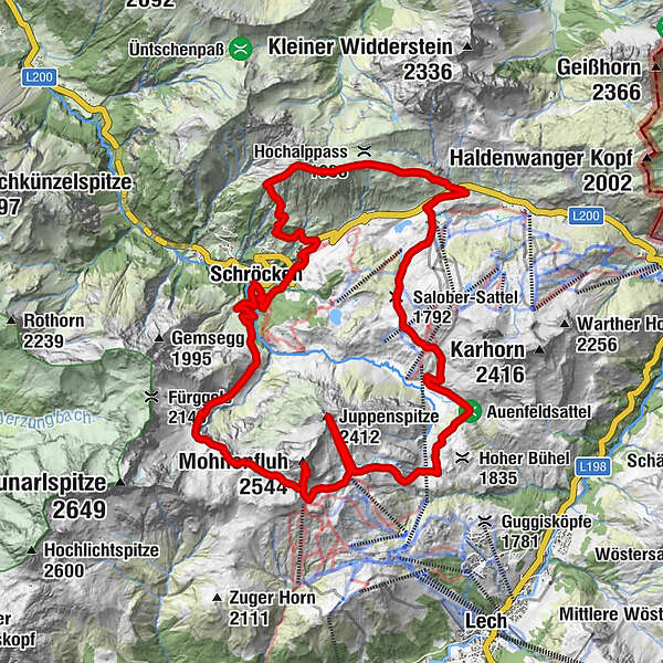
Schröcken (1,269 m)Materialseilbahn Körbersee0.0 kmMohnenfluh (2,544 m)6.9 kmJuppenspitze (2,412 m)9.7 kmUntere Auenfeldalpe14.5 kmObere Auenfeld Alpe (1,732 m)15.4 kmSalober-Sattel (1,792 m)16.8 kmS118.2 kmSB-Restaurant Salober18.2 kmKörblliftle18.4 kmAlpekörb18.4 kmHöferspitze (2,131 m)22.4 kmHolzschopf25.5 kmNesslegg25.5 kmMaterialseilbahn Körbersee27.8 kmSchröcken (1,269 m)27.9 km
- Best season
-
JanFebMarAprMayJunJulAugSepOctNovDec
- Description
-
Touring.
Schröcken village square - Fellalpe - Hochgletscher - Jägersteig - Butzensee - Mohnenfluhsattel - Mohnenfluh - Mohnenfluhsattel - Auenfeld - Juppenspitze - Auenfeld - Salobersattel - Hochtannbergpass - Höferspitze - Schlößle - Nesslegg - Schröcken village square
- Directions
-
Touring.
Schröcken village square - Fellalpe - Hochgletscher - Jägersteig - Butzensee - Mohnenfluhsattel - Mohnenfluh - Mohnenfluhsattel - Auenfeld - Juppenspitze - Auenfeld - Salobersattel - Hochtannbergpass - Höferspitze - Schlößle - Nesslegg - Schröcken village square
- Highest point
- 2,525 m
- Endpoint
-
Schröcken village square
- Height profile
-

- Equipment
-
This should never be missing on the mountain.
Backpack, First-Aid Set incl. Bladder plaster, telephone with emergency number, cash, drinking bottle, pocket knife, provisions, sun protection in good weather.
- Safety instructions
-
Emergency numbers.
140 - Alpine emergencies throughout Austria
144 - Alpine emergencies in Vorarlberg
112 - Euro emergency call
- Additional information
- Directions
- Public transportation
- Parking

- Author
-
The tour Seven Summits Weekend (Stage 2 of 2) is used by outdooractive.com provided.