- Brief description
-
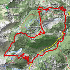
Leisurely mountain bike tour on the old road along the Alvierbach stream from Bürs to Brand.
- Difficulty
-
medium
- Rating
-
- Starting point
-
Village centre, Bürs
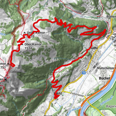
- Route
-
Gasthof SternRestaurant RoseneggBürsBludenz0.2 kmBludenz17.6 kmGasthof Stern17.8 kmRestaurant Rosenegg17.8 kmBürs17.8 km
- Best season
-
JanFebMarAprMayJunJulAugSepOctNovDec
- Description
-
This leisurely tour starts in the centre of Bürs and leads along the old road connection to Brand. From the main road in Bürs, branch off into Werkstraße and after a short while into Schaßweg. As soon as you have reached the Schaßweg, it leads you from Bürs up to the Schaß, further to the Klostermaisäß until you reach the golf course in Brand. At the golf course, the path now branches off over a bridge in the direction of the district of Galaferda and runs along the main road into the centre of Brand. Return for the tour via the same path.
- Directions
-
Bürs village centre - Werkstraße - Schaßweg - follow the road - Schaß - Klostermaisäß - bridge - Galaferda district - Brand village centre - return the same way
- Highest point
- 994 m
- Endpoint
-
Village centre, Bürs
- Height profile
-

- Equipment
-
Mountain bike, helmet, rain or sun protection as well as small snacks and enough water to drink. Mobile phone in case of emergency.
- Safety instructions
- Tips
-
The Schaß above the village Bürs is perfect for a rest.
- Directions
- Public transportation
- Parking
-
Parking lot in the centre of Bürs, directly at the municipal office of Bürs or at the sports field


- Author
-
The tour From Bürs to Brand | Bürs-Brand is used by outdooractive.com provided.


General info
-
Appenzellerland
151
-
Brandnertal
208
-
Bürserberg
65
")


")