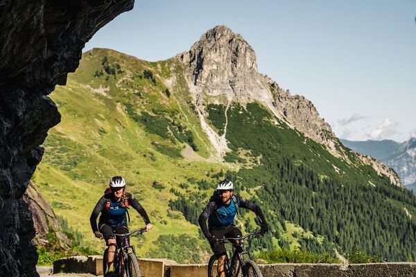
- Brief description
-
This popular Transalp route takes experienced Transalp mountain bikers from Oberstdorf all the way down to Lake Garda.
- Difficulty
-
difficult
- Rating
-
- Starting point
-
Village centre, Warth
- Route
-
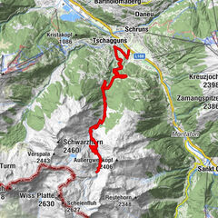
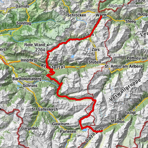
Warth (1,495 m)Bildegg0.2 kmTeschenberg0.3 kmMaterialseilbahn Bürstegg3.3 kmGotikkirche Hl. Nikolaus6.6 kmLech (1,444 m)6.8 kmZug9.5 kmSebastianskirche9.6 kmKlösterle10.3 kmGasthof Auerhahn10.3 kmMaterialseilbahn Göppinger Hütte13.0 kmGasthaus Älpele13.0 kmFormarinalpe19.7 kmMason27.5 kmUntermarias29.0 kmSt. Oswald29.4 kmDalaas (835 m)29.7 kmInnerkristberg36.8 kmKnappenkirche St. Agatha36.9 kmPanoramagasthof Kristberg (1,443 m)36.9 kmKnappastoba37.1 kmKristbergbahn37.2 kmSiebenbrünnele (1,536 m)39.8 kmAP Wildried41.2 kmGretschbach-Wasserfall43.7 kmGiesla Fuchsschwanz - Wasserfall48.0 kmPeter-Käß-Hütte66.3 kmNeue Heilbronner Hütte66.4 kmWinterjöchle (2,272 m)66.6 kmAlpengasthof Zeinisjoch74.7 kmKleinzeinis77.5 kmWirl78.4 kmSt. Antonius Kapelle78.8 kmLandle79.9 kmWinkl80.1 kmGaltür (1,582 m)80.2 kmEgg80.2 kmPfarrkirche80.3 km
- Best season
-
JanFebMarAprMayJunJulAugSepOctNovDec
- Description
-
The Transalp route from Oberstdorf to Lake Garda leads in stages through the eastern part of Vorarlberg. Bikers arrive in Warth via the Schrofenpass. Via Lech, Dalaas and Silbertal you ride to the Heilbronner Hütte and on to Galtür.
From Warth, follow the road towards Lech. In the centre of Lech, turn right towards Zug. From Zug through the Zuger valley in the direction of Formarinsee. Continue straight on in the forest (left towards Spullersee) until you reach the Formarin Alpe. From there, go halfway round the Formarinsee until you reach the Freiburger Hütte. From the hut, take the steep goods road to Alpe Rauher Staffel and continue on a singletrail to Dalaas. This section of the trail is very challenging, only below 1200 metres do you return to the goods road down to Dalaas. The next ascent to the Kristbergsattel starts to the right of the Kristbergsaal. From the Kristbergsattel, descend a short distance before continuing eastwards towards Wildried and Wasserstuben valley. In the Wasserstuben valley, head downhill towards the Fellimännle inn. From here through the rear Silbertal valley, past the Untere Gafluna Alpe and the Obere Felle Alpe to the Winterjöchle. Here you have to push/carry your bike over the Winterjöchle. In Schönverwalltal, the Transalp route takes you up to Heilbronner Hütte. From here downhill to Kops and over the Zeinisjoch down to Galtür.
IMPORTANT NOTE: The "Fellimännle - Silbertaler Winterjöchle" section may not be used from 16 September to 14 June each year. This section is closed to bikers during this time in accordance with the Verwall European Protected Area Ordinance.
- Directions
-
Warth - Lech - Freiburger Hütte - Dalaas - Kristberg - Silbertal - Heilbronner Hütte - Kops - Galtür
From Warth on the road towards Lech. Lech village centre - turn right to Zug. From Zug straight on through the valley. In wooded area straight on (to the left is the Spullersee). Formarin Alpe - shortly after Formarinsee - go halfway around - Freiburger Hütte. From the hut on steep goods road to Alpe Rauher Staffel. Very demanding trail section - below 1200m again on goods road - down to Dalaas. To the right of Kristbergsaal - ascent to Kristbergsattel. South side of Kristbergsattel - short, very steep section - east into Wasserstubental. Valley floor - cross the stream - descent to Silbertal. Gh. Fellimännle - on goods road through the Silbertal - left uphill - Untere Gafluna Alpe - Obere Felle Alpe. Push/carry bike over Winterjöchle - Schönverwalltal. Water catchment of the Rosanna - out of the valley to the main path or carry the bike up to the main path - steeply up the valley - end of the goods road - carry the bike up to the lakes at the Heilbronner hut. Downhill to Kops - pass the Verbella Alpe. Below Kops on path - left up to Zeinisjoch - down to Galtür.
- Highest point
- 2,303 m
- Endpoint
-
Village centre, Galtür
- Height profile
-

- Equipment
-
Mountain bike, helmet, rain or sun protection as well as clothing and food for several days.
- Safety instructions
-
Please note that this tour is very difficult, strenuous and can only be ridden by MTB professionals.
EMERGENCY CALL
140 Alpine emergencies Austria-wide
144 Alpine emergencies Vorarlberg
112 Euro emergency call (works with any mobile phone/network)www.alpenregion-vorarlberg.com/sicherheitstipps-mountainbike
- Directions
- Public transportation

- Author
-
The tour Alpencross through Vorarlberg | Klostertal is used by outdooractive.com provided.