- Brief description
-
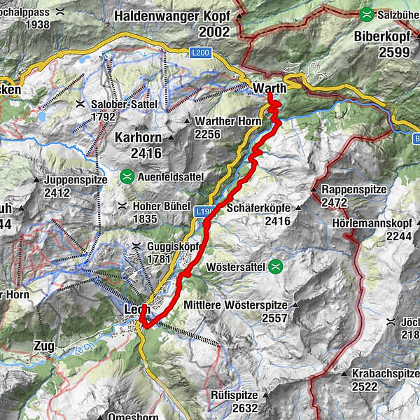
125 kilometres cannot be covered in a single day. This second leg of the hike takes you above the ”Lech canyon” all the way to Warth.
- Difficulty
-
easy
- Rating
-
- Starting point
-
Lech am Arlberg
- Route
-
Gotikkirche Hl. Nikolaus0.0 kmLech (1,444 m)0.2 kmMaterialseilbahn8.0 kmTeschenberg8.5 kmBildegg9.1 kmWarth (1,495 m)9.3 km
- Best season
-
JanFebMarAprMayJunJulAugSepOctNovDec
- Directions
-
The walk begins at the hike starting point in front of the post office. Follow the ”Bodenalpe” trail described above until you reach a narrow track that branches off sharply to the left towards (1) Boden alpe. Stay on the wide forest path that takes you above the ”Lech canyon” to a (2) small wooden bridge across the Lech. From here, continue upstream, first along a wagon road and later along a narrow paved road that leads to (3) Warth town centre. The hiking bus will take you back to Lech am Arlberg from here. If you enjoyed the Lech path, you can continue along it all the way to Füssen im Allgäu.
- Highest point
- 1,535 m
- Endpoint
-
Warth
- Height profile
-

- Equipment
-
Good footwear (ankle high, profile sole), rain protection, Lech Card and bus timetable.
- Safety instructions
-
EMERGENCY CALL:
140 Alpine Emergencies Austria-wide
144 Alpine Emergencies Vorarlberg
112 Eruo emergency call (works with any mobile phone/network)
www.vorarlberg.travel/sicherheitstipps
- Tips
-
Special features: The path can also be walked in the opposite direction.
Sights: Warth town centre – the parish church St. Sebastian and the Walserhus house are impressive testimonies to the Walser arts and crafts.
Refreshment stops: Bodenalpe, restaurants in Warth and Lech am Arlberg.
- Additional information
- Directions
-
From Germany: Take the A96 motorway to Bregenz from there on the A14 motorway to Bludenz, continue on the S16 to the Lech Zürs am Arlberg exit. Follow the B197 up to Alpe Rauz, turn left here onto the B198 through Flexengalerie and over the Flexenpass to Lech Zürs am Arlberg.
From Switzerland: Via the A13 motorway and the Feldkirch, Hohenems or Lustenau border crossing on the A14 motorway to Bludenz. Continue on the S16 until exit Lech Zürs am Arlberg. Follow the B197 up to Alpe Rauz, turn left here onto the B198 through Flexengalerie and over the Flexenpass to Lech Zürs am Arlberg.
From Austria: Via the Inntalautobahn A12 and then via the S16 to the exit St. Anton am Arlberg (Arlberg Pass). Follow the B197 first through St. Anton, then through St. Christoph and over the Arlbergpass to Alpe Rauz. Turn right here onto the B198, drive through Flexengalerie and over the Flexenpass to Lech Zürs am Arlberg.
- Public transportation
-
By train to Langen am Arlberg station or St. Anton am Arlberg. From there, buses (No. 750+760) run regularly to Lech Zürs am Arlberg.
- Parking
-
You can either park your vehicle directly at your host or park it in the underground garage in Anger. The underground car park is located directly in the centre of town opposite Raiffeisenbank Lech.

-

-
AuthorThe tour Lechweg – 2. Leg is used by outdooractive.com provided.