- Brief description
-
Perfect couple-hours walk immersed in nature and cuddled by the sound of the flowing water.
- Difficulty
-
easy
- Rating
-
- Starting point
-
Rifugio Carlettini Church
- Best season
-
JanFebMarAprMayJunJulAugSepOctNovDec
- Description
-
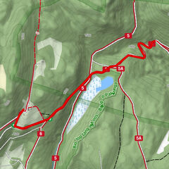
Nearby the mountain dew Carlettini in the wood starts the path L32 called " Sentiero dell'acqua" (way of water) that follows the water of the torrent Maso.Along this path there are green areas with picnic places ideal for some hours in nature to admire the fantastic lawns of bridge of Conseria (1468m o.s.l.). From here you reach also the hut Agritur Malga Casarina and after the path Nomadi, that goes downhill till the mountain dew Carlettini. Return to the starting point following an asphalt raod.
- Directions
-
Difficulty: T (touristic)
The Water’s path L32 starts in the woods next to Rifugio Carlettini’s church and runs along the Maso brook.
Along the route you will find several benches, tables and barbecues.
Follow the same path on the way back.
- Highest point
- 1,472 m
- Endpoint
-
Rifugio Carlettini
- Height profile
-
 © outdooractive.com
 - Equipment
-
The usual outfit for excursions to the mountain is suggested (hiking boots and clothing, raincoat if it rains).
- Safety instructions
-
Plan your itinerary ahead Choose an itinerary that suits your physical abilities Choose suitable equipment and repair kit Check weather forecast Setting out by yourself is riskier; if this is the case take a mobile phone Leave information about your itinerary and your expected return time Do not hesitate in placing your trust in a professional Pay attention to signposts and directions that you find along your way Do not hesitate in going back In case of emergency call 112
Please note that the practicability of the itineraries in a mountain environment is strictly linked to the contingent conditions and is therefore influenced by natural phenomena, environmental changes and weather conditions. For this reason, the information contained in this page may have changed. Before leaving for a tour, make sure the path you will approach is still accessible by contacting the owner of the mountain hut, the alpine guides or the visitor centres of the nature parks, the info offices of the local tourist board.
- Tips
-
The Valley boasts 3 Alpine huts: Rifugio Carlettini (mt. 1368) reachable with the car and Rifugio Consèria and Rifugio Caldenave reachable on foot, horse or mtb
- Directions
-
From the Valsugana highway 47,take the exit for Strigno and then drive on to Spera in order to follow the single road that leaves the village and takes to Val Campelle. Once arrived in locality Cenon go on up to Rifugio Carlettini.
- Parking
-
Car Park at rifugio Carlettini

-
-
AuthorThe tour Walk - The water's path (Sentiero dell'acqua) is used by outdooractive.com provided.