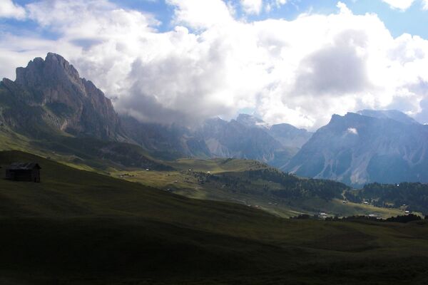

- Brief description
-
Walks
- Difficulty
-
easy
- Rating
-
- Starting point
-
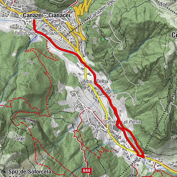
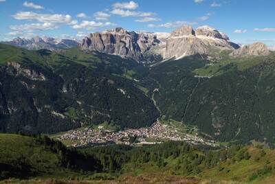
CANAZEI (Strèda Roma - Parco giochi)
- Route
-
Kanzenei0.0 kmAlba1.4 kmAlba4.1 kmKanzenei5.5 km
- Best season
-
JanFebMarAprMayJunJulAugSepOctNovDec
- Description
-
Starting from the Canazei playground, take the dirt road behind the Ski School building along the "Avisio" river, until you come out of the village near the bridge "Pènt de la Roa". Cross the national road and turn left onto the asphalt road (called "Strèda dò Veisc") running close along the "Avisio" river. The track, which is mostly even, alternates shady little woods and open areas. The walk is well equipped with tables and benches. Approximately half-way you reach a playground for children. Continue until the end of the road and get onto the national road at the beginning of "Penìa", near the bridge over the "Avisio". Go back to Canazei going over this bridge to the right and go down the left bank of the torrent. Pass by the ice stadium, cross the bridge on the right and walk back to the starting point along the same route.
- Directions
-
Starting from the Canazei playground, take the dirt road behind the Ski School building along the "Avisio" river, until you come out of the village near the bridge "Pènt de la Roa".
Go back to Canazei crossing the bridge over the "Avisio" to the right and go down the left bank of the torrent. Pass by the ice stadium, cross the bridge on the right and walk back to the starting point along the same route. There are fountains, picnic areas and playgrounds for children along the whole walk.
- Highest point
- 1,495 m
- Endpoint
-
CANAZEI (Strèda Roma - Parco giochi)
- Height profile
-
 © outdooractive.com
 - Equipment
-
Wear adequate clothing, footwear and equipment suitable for the length and grade of difficulty of trail to be taken. Always try to be self-sufficient and carry with you the necessary to face possible emergency situations and a first aid kit.
- Safety instructions
-
For your hikes in mountain always choose itineraries in accordance with your technical and physical abilities. Consult maps of the area to visit and check the best way to follow. If you walk in group including slower hikers, always calculate longer average times to cover the distances.
Preferably do not hike alone in mountain. Otherwise tell someone the itinerary that you are going to follow and let him know when you are back.
Check the weather forecast and, while hiking, constantly pay attention to the evolution of the weather.
If you do not feel safe, give up. In mountain, sometimes, it is better to surrender than to face the dangers deriving from bad weather conditions or from difficulties superior to one’s limits. In advance look for alternative itineraries to get back.
Bring rubbish back with you. Respect the flora and fauna. Remain on the marked tracks, avoiding to follow shortest ways, in order to avoid causing damages to vegetation and the territory. Respect local cultures andtraditions, always bearing in mind that you are a guest.
- Tips
-
Suitable for strollers, suitable for families with children, walkable with toddler-carrier/backpack
- Additional information
- Arrival
-
Main access points to Val di Fassa, coming from the A22, Modena-Brennero motorway:
- Ora / Egna exit, S.S. 48 delle Dolomiti - San Lugano Pass - Val di Fiemme - Val di Fassa (distance 45 km). At the roundabout in Moena, follow the direction of Canazei upwards;
- Bolzano Nord exit, S.S. 241 Grande Strada delle Dolomiti - Carezza Pass -Vigo di Fassa (distance 40 km). From Vigo follow direction Canazei upwards or the direction Soraga di Fassa and Moena downwards;
Other accesses to the Val di Fassa:
- from the A27 motorway (Venice), Belluno / Ponte nelle Alpi exit, then take S.S. 203 to Agordo and S.P. 346 to San Pellegrino Pass - Moena (Val di Fassa). At the roundabout in Moena, follow the direction of Canazei upwards;
- from the A27 motorway (Venice), exit Belluno / Ponte nelle Alpi, S.S. 203 to Agordo / Alleghe / Rocca Pietore first and S.P.641 to Fedaia Pass - Canazei;
- coming from Arabba, S.S.48 Pordoi Pass - Canazei;
- from Val Gardena, S.S.242 Passo Sella - Canazei.
- Public transportation
-
Regular bus service operated by the bus company Trentino Trasporti in Val di Fassa:
bus line n. 101 Canazei - Cavalese - Trento
bus line n. 104 Cavalese - Ora - Trento
bus line n. 123 Moena - San Pellegrino Pass - Falcade
Regular bus service operated by the bus company SAD in Val di Fassa:
bus line n. 180 Pozza di Fassa - Vigo di Fassa - Passo Carezza - Bolzano
bus line n. 471 Dolomites Passes (Sella Pass, Gardena Pass, Campolongo Pass, Pordoi Pass, Fedaia Pass). Only in summer
- Author
-
The tour Canazei - Pènt de la Roa - Molin - Alba Penìa - Canazei is used by outdooractive.com provided.


General info
-
Dolomiten
1808
-
Sellaronda
1099
-
Canazei
377