
- Brief description
-
Halfway route between the meadows of Monte Altissimo
- Starting point
-
Rifugio A. Graziani
- Route
-
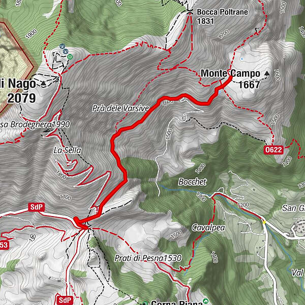
Rifugio Graziani0.2 kmMalga Campo2.4 km
- Description
-
The route leads from the Graziani Refuge to Malga Campo along a scenic dirt road.
- Directions
-
From Rifugio Graziani take the dirt road that runs alongside Monte Altissimo following the signs for itinerary E650. Along the route, especially in the morning or at sunset, it is easy to spot chamois and marmots
- Highest point
- 1,659 m
- Endpoint
-
Rifugio A. Graziani (round trip on the same route).
- Height profile
-
 © outdooractive.com
 - Safety instructions
-
Please note that the practicability of the itineraries in a mountain environment is strictly linked to the contingent conditions and is therefore influenced by natural phenomena, environmental changes and weather conditions. For this reason, the information contained in this page may have changed. Before leaving for a tour, make sure the path you will approach is still accessible by contacting the owner of the mountain hut, the alpine guides or the visitor centres of the nature parks, the info offices of the local tourist board.
- Tips
-
Along the itinerary, especially in the morning or at dusk, it is easy to see chamois and marmots.
- Directions
-
From the A22 Rovereto Sud motorway exit take the direction of Mori - Brentonico, then take the S. Valentino pass. Here continue to Rifugio Fos-ce, Rifugio Graziani.
- Parking
-
Close to Rifugio Graziani.
-

-
AuthorThe tour From Rifugio Graziani to Malga Campo is used by outdooractive.com provided.