
- Brief description
-
The path from the village of Cembra to Lago Santo follows part of the ancient Via Claudia Augusta which connected Trento with Tyrol.
- Difficulty
-
easy
- Rating
-
- Starting point
-
Cembra
- Route
-
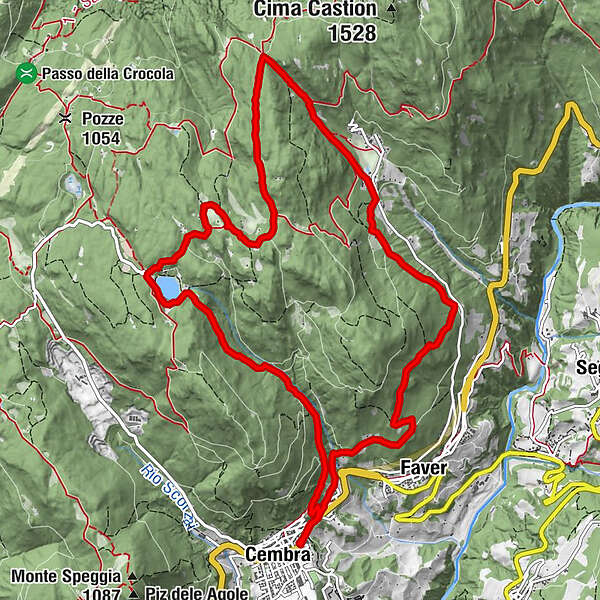
CembraFadana0.4 kmFaver1.5 kmRifugio Lago Santo9.9 kmHerberege am Heiligen See9.9 kmCappella della Madonna degli Alpini10.1 kmFadana13.4 kmCembra13.8 km
- Best season
-
JanFebMarAprMayJunJulAugSepOctNovDec
- Description
-
The famous German engraver and painter Albrecht Dürer followed this route in 1494 as did Napoleonic troops some three centuries later on their way to the Castle of Segonzano.
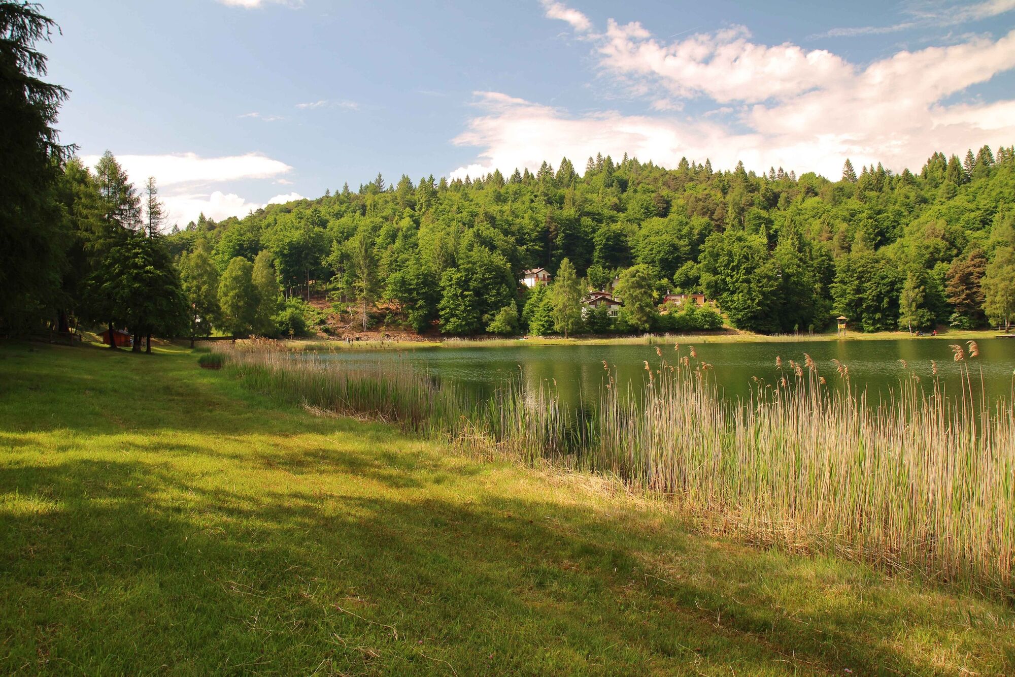
The route develops in the woods, interspersed with clearings where the "huts" of the locals, with the porphyry roof slabs according to the tradition or more modern ones, have been built, and with meadows protected by the typical dry stone walls. Halfway along the ring route appears the Santo lake, of immaculate beauty.
- Directions
-
From the car park in front of the winery 'Cantina Valle di Cembra', walk in direction Faver along the main road until you reach a traffic light. From here, take the road that climbs to the left, arriving shortly in the small square of the contrada of Fadana. When you reach the square in Fadana near the fountain, take the road on the right that rises between the vines towards the woods above. After a very steep and cemented section of road, continue until you come to a fork in the road, where, ignoring the road that descends towards the valley, you turn left and continue uphill into the woods. On reaching the third hairpin bend, a path branches off to the right, causing the hiker to lose a little altitude until, at a fork in the road, keeping to the left, the ascent begins again. As you gain height, the path becomes flatter and takes on tractable characteristics. At the umpteenth crossroads encountered, we descend along the forest road, which in the last section has a cemented surface. At the end of the steep descent, we come to the signpost indicating Ponciach/Lago Santo and climb up the paved road, which climbs gently towards the forest. When you reach a house on the right-hand side of the road, you will find a small meadow where the path runs, at first difficult to spot but then evident, which soon leads to the outskirts of the small, pleasant hamlet of Ponciach. The signs are now abundant, and so, following the signs for Lago Santo, we ascend into the wood on a beautiful road that for long stretches has porphyry paving, and thus reach a fork in the road at loc. Casalini: from here we follow the signs for loc. Zise, along a cobbled road, until, passing near a large wooden capital, we see the signs for Lago Santo on the left. The forest road passes, at first, just below the summit of Monte Pincaldo, then at loc. Sach to continue towards the Lago Santo refuge. A small diversions to the left allows you to cross the loc. Vegiose with its beautiful meadows where several huts can be seen here and there. Having reached Lago Santo, begin the descent, following the signs for Cembra (E5 - 410). The path, which is steep in places, crosses the forest road in the locality of S. Antonio; follow this road until you reach the next signposts that lead you to abandon it in order to descend along the old route of the Via Claudio-Augusta towards Fadana and shortly to the starting point. In places, the route coincides with the modern and recent route of the E5 - one of Europe's fascinating trails - which runs from the Atlantic in France or more frequently from Lake Constance in Switzerland to the city of Verona. Through here passed a variant of the Roman Claudia Augusta and later the medieval Semita Caroli, alternatives to the Adige Valley road system, which the great river often flooded over the millennia, up to the embankments of the 20th century. The illustrious young wayfarer Albrecht Duerer passed through here in 1494 (www.durerweg.it), followed three centuries later by Napoleon's troops on their way to Segonzano Castle.
- Highest point
- 1,294 m
- Endpoint
-
Cembra
- Height profile
-
 © outdooractive.com
 - Equipment
-
Hiking shoes, rain-jacket, hiking poles, water, snack and sun cream.
- Safety instructions
-
THE 10 RULES FOR HIKERS
Prepare your itinerary beforehand Choose an itinerary that suits your physical abilities Choose suitable clothes and equipment Check the weather forecast Hiking by yourself is more risky; if this is the case, take a mobile phone with you Leave information about your itinerary and your expected return time If you are not sure about your itinerary, contact an Alpine Guide Pay attention to signposts and directions that you find along your way Do not hesitate in going back if you feel too tired In case of emergency call 112 - Tips
-
Each place has its own history and Santo Lake hides a bit of sacred magic ... discover its history in the legends on https://www.visitpinecembra.it/psc/storie-e-leggende-locali
- Additional information
- Directions
-
From south or north, on the A22 Brennero motorway, leave the motorway at the Trento Nord exit (22.5 km from the toll gate), continue northwards on the Main Brennero Road SS12 until the turn-off for Lavis, then take the Lavis - Castello di Fiemme Main Road SS612 which will take you to the Cembra Valley.
- Public transportation
-
From the Trento bus station, take line B102 towards Cavalese (Trento - Cembra - Capriana - Cavalese) and get off at Cembra.
- Parking
-
Several free parking lots are available along Viale IV Novembre (the main street that crosses the town of Cembra).


- Author
-
The tour From Cembra to Lago Santo is used by outdooractive.com provided.