
- Brief description
-
An original 64-kilometer route that explores the banks of Trent and the Adige plain
- Difficulty
-
medium
- Rating
-
- Starting point
-
Cathedral Square, Trento
- Route
-
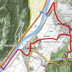
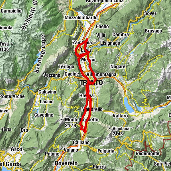
Centro storicoTrient (194 m)0.0 kmÉglise de la Sainte Annonciation0.1 kmchiesa di San Francesco Saverio0.2 kmTrient0.7 kmAbbazia di San Lorenzo0.8 kmPiedicastello1.2 kmFunivia Trento Sardagna1.3 kmex SIT1.3 kmLe Albere2.2 kmSan Pio X3.2 kmRavina5.4 kmMaso Stella6.3 kmRomagnano (235 m)8.1 kmValle (186 m)8.8 kmRoma12.9 kmAldeno13.0 kmMattarello22.3 kmLe Albere28.5 kmTrient (194 m)29.5 kmFunivia Trento Sardagna29.6 kmPiedicastello29.6 kmCristo Re30.5 kmVela31.8 kmLavis38.8 kmNave San Rocco47.3 kmHotel Ristorante Alla Nave48.0 kmNave San Felice (208 m)48.1 kmMaso Callianer48.5 kmMaso Rover48.5 kmPressano (285 m)49.5 kmPizzeria Dolomiti51.4 kmLavis51.4 kmPristol51.7 kmChiesa di Sant'Udalrico52.1 kmSan Lazzaro di Meano (232 m)52.6 kmMeano Due53.8 kmMeano54.4 kmChiesa di Santa Maria Assunta54.4 kmCrosara del Mazzalai (460 m)57.4 kmMaso Bolleri57.6 kmPinara (390 m)58.3 kmMartignano59.5 kmCognola60.9 kmLaste61.6 kmSan Donà61.7 kmchiesa di San Marco63.2 kmSanti Pietro e Paolo63.4 kmTrient (194 m)63.4 kmCentro storico63.5 kmÉglise de la Sainte Annonciation63.8 km
- Best season
-
JanFebMarAprMayJunJulAugSepOctNovDec
- Description
-
The protagonists of the route are the city of Trento and the valley crossed by the Adige River, along whose banks a dense network of bicycle paths, picturesque white roads surrounded by nature, the discovery of characteristic villages and passages in the history of the Via Claudia Augusta, the ancient Roman road, unfold.
- Directions
-
It starts from Piazza Duomo in Trento, takes Via Belenzani and reaches Piazza Dante. The route circles the square and then, taking the overpass beside the bus station, leads along the Adige River heading south. It continues through the Albere district with the MUSE and the architecture designed by Renzo Piano and then takes Via Ghiaie, passes the traffic circle and continues along Via al Desert. Continue south crossing the bridge and entering the built-up area of Ravina and then straight ahead along the SP 90 right Adige towards Romagnano and Aldeno.
Once in Aldeno about 100 meters from the elementary school is the entrance to the unpaved dirt road that crosses the countryside of Aldeno and approaches the Adige River. You then begin the route back toward Trento (northbound) by flanking the banks of the river.
At the height of Mattarello cross the bridge that leads to the town and take the Adige Valley cycle path in a northerly direction.
Follow the cycle path to the Ravina bridge, then cross the bridge and continue on the cycle path to the mouth of the Avisio River in Lavis. Cross the Avisio River and continue on the bicycle path to the bridge at Nave San Rocco.
You then take the underpass and begin the return journey toward Trento, passing through the village of Nave San Felice and then along the Via Claudia Augusta. The route passes through secondary country roads, crosses the built-up area of Pressano and comes out in the historic center of Lavis. From San Lazzaro begins the ascent that leads to Meano and then cuts through the Argentario mountain halfway up, connecting the village of Meano to Martignano. Once in Martignano, continue toward the village of Cognola appreciating the panorama of vineyards and the view of the Adige Valley. Once in the village, take Via alla Pellegrina to Pizzeria 4 stagioni and then continue in the direction of Santuario delle Laste and along Via dei Giardini until reaching Piazza Venezia and then the starting point of Piazza Duomo.
- Highest point
- 457 m
- Endpoint
-
Cathedral Square, Trento
- Height profile
-
 © outdooractive.com
 - Equipment
-
Hiking bikes require specific clothing and equipment even for relatively short and easy outings.
Choose the right type of bike for the route to be taken (each bike has specific technical characteristics and different performance based on the type of circuit).
Bring with you:
adequate supply of water (or minerals) based on your needs (consider temperature, possibility of refueling, duration of the route) snacks (e.g., dried fruit or bars) wind and rain jacket reflective jacket (or reflective suspenders) spare jersey and socks sunscreen sunglasses helmet bike gloves map or gps device flashlight preferably helmet or handlebars first aid kit bike repair kit to remedy mechanical accidents (tire levers, mini pump, spare inner tube) signal whistle - Safety instructions
-
Carefully consider the type of route, stages, current season, and weather conditions so as not to run into unforeseen problems (especially if in a mountain environment).
Before setting out, inquire about the status of the route by contacting the tourist offices, the manager of the huts on your route, and the mountain guides as the information in this sheet may change.
The roads, trails and tracks indicated are often also traveled in the opposite direction, so always watch out for pedestrians, bikes and cars coming over On trails and in tight spots watch out for hikers and use common sense, slow down and stop if necessary Always wear a helmet and do not underestimate the degree of difficulty of the trail Respect speed limits and ride in such a way that you are always in control of your bike Take any trash with youAlways inform someone of your destination and timing. The single emergency number is 112.
- Tips
-
Refreshments are available in bars and cafes in the towns crossed by the route; in southern Trento the route passes through the Trento Bici grill.
- Additional information
-
Trento Tourist Office - Tel. +39 0461 216000 - info@trento.info - www.trento.info
- Directions
-
Trento can be reached by the A22 Brenner Motorway or the SS12.
- Public transportation
- Parking


- Author
-
The tour Bicycle touring along the Adige plain is used by outdooractive.com provided.