- Brief description
-
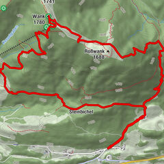
Genießen Sie eine leichte Dorfrunde von Scharnitz nach Gießenbach.
- Route
-
Natur-Erlebnis-Spielplatz bei der HolzerhütteFlorianikapelle0.3 kmBella Vista zum Kirchplatzl0.4 kmScharnitz (964 m)0.4 kmKath. Pfarrkirche Mariahilf0.5 kmGießenbach3.3 kmScharnitz (964 m)5.6 kmNatur-Erlebnis-Spielplatz bei der Holzerhütte6.1 km
- Highest point
- 1,008 m
- Endpoint
-
Naturpark-Infozentrum Scharnitz (P2)
- Height profile
-

- Author
-
The tour Dorfrunde Scharnitz - Gießenbach is used by outdooractive.com provided.
GPS Downloads


Other tours in the regions