
- Brief description
-
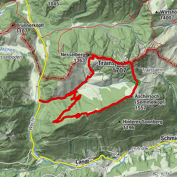
The round tour via Saurüssel, Ascherjoch and Trainsjoch offers wonderful quiet paths combined with challenging climbs.
- Difficulty
-
medium
- Rating
-
- Starting point
-
Parking Ursprung
- Route
-
Mariandlalm (1,250 m)2.3 kmTrainsjoch (1,707 m)4.2 kmSaurüssel6.3 km
- Best season
-
JanFebMarAprMayJunJulAugSepOctNovDec
- Description
-
From the car park at Ursprungpass, the trail first leads along a good piece of forest road up to the Ascherjochalm. From there the path becomes a path and leads up through enchanted forests over the Saurüssel and the Ascherjoch. Both "peaks" are rather inconspicuous, but the path is very pleasant to walk. Afterwards it goes short and slightly downhill to gain some steepness on the other side to the Trainsjoch. At the summit it is best to pause for a moment and then continue in the direction of Mariandlalm. A stop in the rustic alpine pasture is strongly recommended to enjoy the homemade apple strudel. Afterwards it goes along the Trockenbach out to the starting point.
- Highest point
- 1,693 m
- Endpoint
-
Parking Ursprung
- Height profile
-

- Equipment
-
Outdoor clothing appropriate to the weather (good footwear, rain protection, breathable clothing...), snacks (e.g. fruit, muesli bars, wholemeal breads) and drinks (make sure you drink enough), first-aid equipment, mobile phone with full battery, hiking map and guide literature, sun protection (sun cream and glasses, cap), bivouac bag
- Directions
-
The Ursprungpass can be reached from Bayrischzell or Thiersee.
- Public transportation
-
With the KufsteinerlandCard within the region bus free of charge.
- Parking
-
Car park Ursprung
- Author
-
The tour Trainsjoch Circuit is used by outdooractive.com provided.


-
Kufsteinerland
2116
-
Thierseetal
460