


- Brief description
-
Alpine pasture circular hiking route with a breathtaking view over Scheffau!
- Difficulty
-
medium
- Rating
-
- Starting point
-
Hiking starting point Tourist Info, Scheffau (738 m)
- Route
-
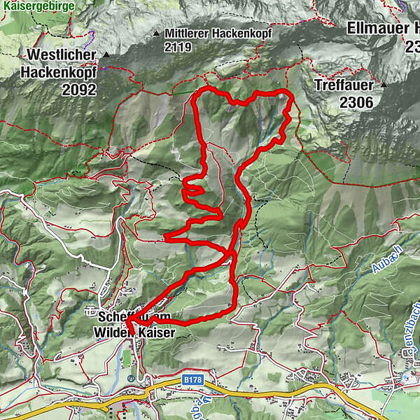
Scheffau am Wilden Kaiser0.0 kmPfarrkirche Scheffau0.1 kmOberfeld0.5 kmMittersbach1.7 kmSteinacker2.0 kmWegscheid2.4 kmGasthof Jägerwirt2.4 kmKaiser-Hochalm6.6 kmKaiseralm / Vorderschiessling Alm7.5 kmSchießling10.2 kmWegscheid11.0 kmGasthof Jägerwirt11.1 kmWaldkapelle12.3 kmOberfeld12.4 kmPfarrkirche Scheffau12.8 kmScheffau am Wilden Kaiser12.8 km
- Best season
-
JanFebMarAprMayJunJulAugSepOctNovDec
- Description
-
From the village center you walk along the Treffauerbach up to the Jägerwirt (No. 814). Continue past the Wegscheid-Niederalm and over the footpath to the Wegscheid-Hochalm (trail no. 826). Walk uphill to the Wilder-Kaiser-Steig (WKS Nr. 823) and follow it to the left towards the west. After approx. 45 minutes you reach the Kaiser-Hochalm, with fantastic views over the Kitzbühel Alps to the Großglockner. Now begins the descent to Kaiseralm (No. 826). The short, steep climb to the Seilabodenkreuz (1.200 m) is directly behind the Kaiseralm, which also offers a refreshment stop. Arriving at the cross, you should stop for a moment and enjoy the view before you follow the path to the Kaiser-Niederalm. From the pasture (not managed) go on the road until just before the farms Schießling. There you turn left to the Jägerwirt (trail no. 826) and return to the village via the driveway.
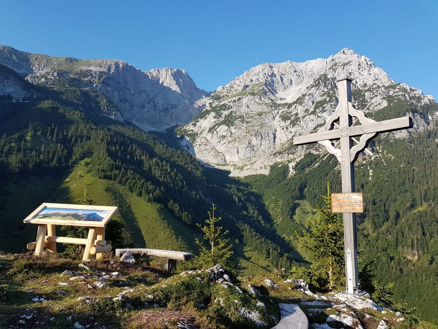
The Sailabodenkreuz invites you to slow down and reflect.
All the Alpine pastures on this route feature picturesque places for a break and the Kaiseralm provides an opportunity for refreshments.
Shorter variant: After the Wegscheid-Niederalm at the crossroads "Kaiseregg" it goes left directly to the Kaiseralm (route no. 814) - this shortens the tour by about 2 hours. - Directions
-
This scenic mountain hike provides a burst of summer freshness in the Wilder Kaiser region. From the village, you should walk along Wegscheidbach stream up to the Jägerwirt inn. Continue past Wegscheid-Niederalm (trail no. 826) and take the footpath to Wegscheid-Hochalm. Head uphill until you come to the Wilder-Kaiser-Steig trail (WKS no. 823) and follow this to the left as you head west. After around 45 minutes, you will reach the Kaiser-Hochalm Alpine pasture and its fantastic view over the Kitzbühel Alps all the way to the Grossglockner. You now begin your descent to the Kaiseralm (no. 826). The short, steep ascent to the Seilabodenkreuz summit cross (1,200 m) is directly behind the Kaiseralm mountain hut, which also provides an opportunity for refreshments. Once you reach the cross, you should pause for a moment to enjoy the view before continuing along the path to the Kaiser-Niederalm (which does not feature any establishments that serve food). From here, head along the road until shortly before the Schiessling farms. Then turn left towards the Jägerwirt inn and take the road back to the village.
What’s special:
The Sailabodenkreuz invites you to slow down and reflect.
All the Alpine pastures on this route feature picturesque places for a break and the Kaiseralm provides an opportunity for refreshments. - Highest point
- 1,451 m
- Endpoint
-
Hiking starting point Tourist Info, Scheffau (738 m)
- Height profile
-

- Equipment
-
Rucksack, sturdy hiking shoes, weather-appropriate hiking gear, sun protection, waterproofs, snack and drink, hiking poles (height adjustable) if required, mobile phone, plastic bag for waste, hiking map, route description and information materials (GPX track), ID, cash
- Directions
-
Heading from Wörgl, Kufstein or St. Johann on the B178 road, take the exit to Scheffau. Shortly before you come to the church, you will see the Tourist Info and the hiking starting point on the left-hand side (short-stay parking zone).
- Public transportation
-
Public car park, Scheffau (740 m), north of the Community Hall - pay & display
- Parking


- Author
-
The tour From the Kaiser-Hochalm to the Seilabodenkreuz is used by outdooractive.com provided.


General info
-
Wilder Kaiser
1945
-
Scheffau am Wilden Kaiser
614


