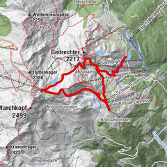
Tour data
17.44km
1,296
- 2,308m
1,082hm
1,083hm
05:10h
- Brief description
-
Wunderschöne Wanderung vom Parkplatz Schönachtal über den Arbiskogel zur Kirchspitze und anschließendem Essen und Trinken in der Jörgleralm.
- Difficulty
-
medium
- Rating
-
- Route
-
Lackenscharte (1,985 m)4.8 kmArbiskogel (2,048 m)5.2 kmKirchspitze (2,312 m)7.3 kmIssalm12.2 kmLackenalm13.7 kmLahneralm14.6 kmJörgleralm im Schönachtal15.7 km
- Best season
-
JanFebMarAprMayJunJulAugSepOctNovDec
- Highest point
- 2,308 m

GPS Downloads


Other tours in the regions
-
Zillertal Arena
1313
-
Gerlos
282