
- Brief description
-
Sunny-side hike that can be walked all year round. In typical Tyrolean surroundings. Along old farms, with a wonderful view of the Inn Valley, the Kellerjoch and the Wattental.
- Difficulty
-
easy
- Rating
-
- Starting point
-
Fritzens
- Route
-
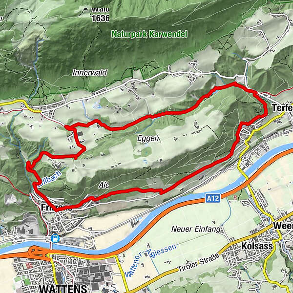
Fritzens (591 m)0.0 kmInnerwald3.0 kmErscheinungskapelle Maria Larch6.4 kmWallfahrtskirche Maria-Larch6.6 kmWasserkapelle Maria Larch6.6 kmTerfens7.5 kmNeu-Terfens7.9 kmFritzens (591 m)12.1 km
- Best season
-
JanFebMarAprMayJunJulAugSepOctNovDec
- Description
-
This easy hike takes us with a wonderful view of the surrounding mountains to the healing spring of the Maria Larch chapel. Always along the sunny side of the Inn Valley to the Gnadenwalder Plateau. Passing old farmhouses and "Materl" along the way.
- Directions
-
Walk from the village center of Fritzens up to the Gnadenwald plateau. South of the Thierburg to the Voreggen and Eggen farms and down to the Chapel Maria Larch. There we taste from the healing spring which is widely known!
Return: the same way or via Terfens/Neu-Terfens to Fritzens. For this you follow the "Besinnungsweg" down to Terfens and from there over to Fritzens.
- Highest point
- 863 m
- Endpoint
-
Fritzens
- Height profile
-

- Tips
-
Fill up the drinking bottle with the healing water at the Maria Larch chapel!
- Directions
-
The best way to arrive by car is via the Inntal autobahn A12 and exit No 61 (Wattens) - follow the signs to Fritzens
- Parking
-
There are plenty of parking spaces right at the starting point.
- Author
-
The tour To the healing water of the Maria Larch Chapel is used by outdooractive.com provided.


General info
-
Ferienregion Hall - Wattens
1477
-
Kolsass
316


