


- Brief description
-
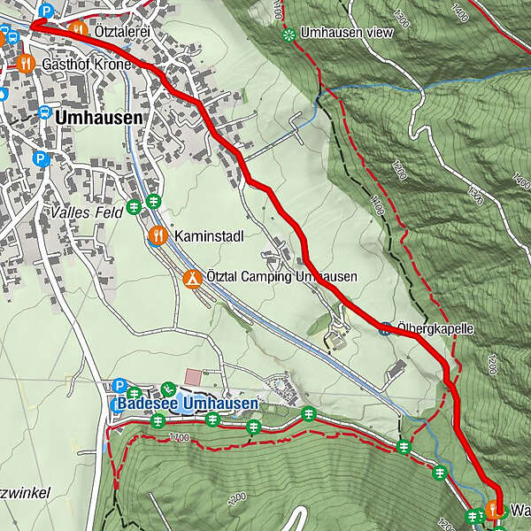
UMHAUSEN -> car park "Mure" -> WALDCAFE STUBÖBELE
- Difficulty
-
easy
- Rating
-
- Starting point
-
car park Mure
- Route
-
Umhausen (1,031 m)0.3 kmÖlbergkapelle1.2 kmWaldcafe Stuböbele1.8 km
- Best season
-
JanFebMarAprMayJunJulAugSepOctNovDec
- Description
-
From the car park "Mure" in the center of Umhausen you walk along the road in the direction of Niederthai until you reach the car park "Bischoffsplatz". Of course you can also start your hike there. Follow the wide forest path towards forest café Stuböbele and Stuibenfall. The path leads past the natural bathing lake as well as the Ötzi village and the terrain of the bird of prey park. You walk through a pretty forest along the stream. Arriving at the forest café Stuböbele, you can relax and enjoy Tyrolean delicacies on the large sun terrace. So far, the way is also accessible for prams and buggies.
- Directions
-
From the car park "Mure" in the center of Umhausen you walk along the road in the direction of Niederthai until you reach the car park "Bischoffsplatz". Of course you can also start your hike there. Follow the wide forest path towards forest café Stuböbele and Stuibenfall. The path leads past the natural bathing lake as well as the Ötzi village and the terrain of the bird of prey park. You walk through a pretty forest along the stream. Arriving at the forest café Stuböbele, you can relax and enjoy Tyrolean delicacies on the large sun terrace. So far, the way is also accessible for prams and buggies. An alternative way from the car park Bischoffsplatz, is the beautiful Waalweg to the rustic forest café.
Alternatively another route is: start at the car park "Mure" and walk in the direction of Rosslachgasse, follow the way on the "Steppsteig" to the "Stuiben Nannele" and continue to the forest cafe Stuböbele.
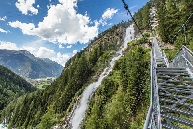
If you would like to continue your hike after the visit in the forest café Stuböbele, you can follow the path to the Stuibenfall, Tyrol's highest waterfall. Over 159 meters this falls into the depth - an absolutely breathtaking spectacle!
- Highest point
- 1,148 m
- Endpoint
-
Waldcafé Stuböbele
- Height profile
-

- Equipment
-
Appropriate equipment such as breathable suitable outdoor clothes for the weather, ankle-high walking boots, wind-, rain- & sun protection, hat, possibly gloves, is for all hikes and tours necessary. Please bring a first-aid box, a mobile phone, a walking map and if there is not hut on the way a snack and enough to drink.
- Safety instructions
- Additional information
- Arrival
-
The car drive to the Ötztal valley. Situated in Tirol, the Ötztal valley set off in southerly direction and is the longest side valley in the Eastern Alps. The journey with the car leads you through the Inntal valley to the entrance of the valley and further on through the valley. Among the toll motorways you can also use the country roads. A route planner will show you the easiest and most convenient way: https://www.google.at/maps
- Public transportation
-
Travel safe and comfortable with the train to the Ötztal Bahnhof train station. Last stop and exit point is the train station Ötztal Bahnhof. Afterwards you can travel smoothly and quick with the public transport or our local taxi companies through the valley to your desired destination. Please find the current bus timetable here: http://fahrplan.vvt.at
- Parking
-
In Umhausen the following parking facilities are available:
- car park "Mure" | free of charge
- car park "Bischoffsplatz" | one day ticket for cars € 5,00, fee required from 7:00 am till 6:30 pm | the car park for people with handicap is free, please deposit your handicap ID apparent in your car | Buses park for free


- Author
-
The tour Waldcafe Stuböbele - Umhausen is used by outdooractive.com provided.


General info
-
Pitztal
1066
-
Umhausen im Ötztal
401


