- Brief description
-
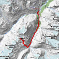
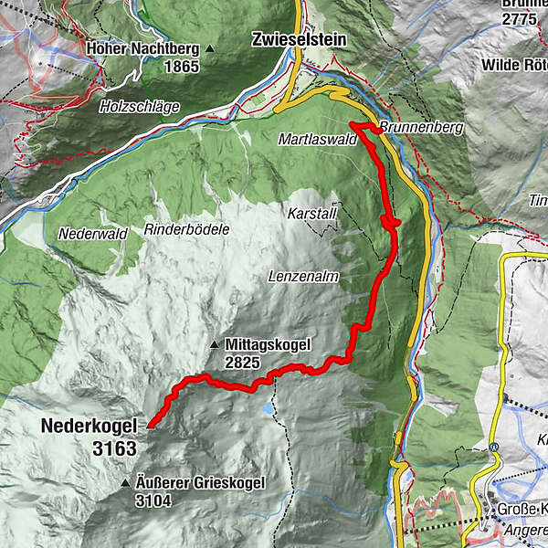
BUSHALTESTELLE LENZENALM --> Lenzenalm --> Abzweigung Nedersee --> NEDERKOGL --> Abzweigung Nedersee --> Lenzenalm --> BUSHALTESTELLE LENZENALM
- Difficulty
-
difficult
- Rating
-
- Starting point
-
Busstopp Lenzenalm - Zwieselstein/Sölden
- Route
-
Nederkogel (3,163 m)6.2 km
- Best season
-
JanFebMarAprMayJunJulAugSepOctNovDec
- Description
-
The Nederkogl is Sölden's local mountain. Mighty it appears at the head of the valley above Sölden.
The ascent over the Lenzenalm and passing the junction of the Nedersee is steadily steep, but the more you will be rewarded at the summit by the magnificent panoramic view of the large three-thousand-meter peaks of the Ötztaler and Stubaier Alps.
- Directions
-
The hike starts directly at the Lenzenalm bus stop or the Lenzenalm parking lot.
From there it takes approx. 1 hour to the Lenzenalm. It goes comfortably up a wide path through the forest. Always slightly uphill, but not very strenuous. The last ascent to the hut is a little steeper, but from there you can enjoy the view of Gurgl.
From the Lenzenalm you walk briefly through the forest - over alpine meadows to the nearby Nedersee (2435m, short detour possible) - on a very steep path via switchbacks you reach the northeast ridge. Over rough stone blocks it goes either on the ridge (marked) or in the east flank (also marked) to the summit cross.
The descent from the Nederkogl is the same route as the ascent!
- Highest point
- 3,121 m
- Endpoint
-
Busstopp Lenzenalm - Zwieselstein/Sölden
- Height profile
-

- Equipment
-
Appropriate equipment such as breathable suitable outdoor clothes for the weather, ankle-high walking boots, wind-, rain- & sun protection, hat, possibly gloves, is for all hikes and tours necessary. Please bring a first-aid box, a mobile phone, a walking map and if there is no hut on the way a snack and enough to drink.
- Safety instructions
-
For experienced mountaineers that are free from vertigo & surefooted, Very good physical condition, mountainexperience & mountain equipment (see notice equipment) necessary, such as alpine security material, goodweather conditions recommended.
Please pay attention to the current weather report:
https://www.soelden.com/winter/live-info/wetter/weather-today.html - Tips
-
On the descent, the Lenzenalm is right on the path and invites you to make a stop.
- Additional information
- Directions
-
The car drive to the Ötztal valley. Situated in Tirol, the Ötztal valley set off in southerly direction and is the longest side valley in the Eastern Alps. The journey with the car leads you through the Inntal valley to the entrance of the valley and further on through the valley. Among the toll motorways you can also use the country roads. A route planner will show you the easiest and most convenient way: https://www.google.at/maps
- Public transportation
-
Travel safe and comfortable with the train to the Ötztal Bahnhof train station. Last stop and exit point is the train station Ötztal Bahnhof. Afterwards you can travel smoothly and quick with the public transport or our local taxi companies through the valley to your desired destination. Please find the current bus timetable here: fahrplan.vvt.at
- Parking
-
The following parking facilities are available in Sölden:
- Parking lot Lenzenalm
- parking Zwieselstein
- parking Zwieselstein / sports ground
All parking is free during the day.


- Author
-
The tour Nederkogl is used by outdooractive.com provided.


General info
-
Meraner Land
1736
-
Ötztal
1107
-
Obergurgl - Hochgurgl
281