- Brief description
-
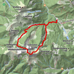
Day 1: from Kramsach via Voldöppberg to Brandenberg --> approx. 5 - 6 h
Day 2: from Brandenberg via the Jocheralm to the Heuberg and Kienberg and descent to Pinegg --> approx. 6 - 7 h
Day 3: from Pinegg via Aschau, Anderl´s Hütte to Lake Zirein and the Bayreuther Hütte --> approx. 7 - 8 h
Day 4: from the Bayreuther Hütte - walk back down to the valley and the starting point --> approx. 2 h
- Difficulty
-
medium
- Rating
-
- Starting point
-
Kramsach/Sonnwendjochbergbahn car park
- Route
-
Radetzkyweg0.0 kmMariatal (533 m)0.2 kmGasthaus Mariathal0.3 kmWallfahrtskirche (Basilika) Hl.Dominikus zu Mariathal0.4 kmVoldöpper Spitze (1,509 m)5.6 kmBrandenberg9.9 kmAscherwirt9.9 kmHeiliger Georg9.9 km
- Best season
-
JanFebMarAprMayJunJulAugSepOctNovDec
- Description
-
Start from the Sonnwendjochbergbahn (defunct chairlift) car park walking along the tarmacked road towards Aschau for approx. 300 m and cross the first bridge to the "Mariathal" pilgrimage basilica. From the basilica follow the signs for "zu den Seen" taking the walking path no. 1 direction lakes. Shortly before Lake Krumm a path leads to the "Voldöppberg". The route - in parts steep - leads directly to the peak at 1.509 m.
To descend bear east up to a small hut and then bear north following the signs for "Brandenberg". On reaching the toboggan run the village centre is only approx. 500 m away. The first night of this tour is spent here.
- Highest point
- 1,501 m
- Endpoint
-
Brandenberg
- Height profile
-

- Equipment
-
Sturdy shoes and protective clothing
- Tips
-
Please note there is nowhere to buy something to eat or drink along the way to Brandenberg! Take sufficient water and a snack with you.
- Directions
-
A12, motorway exit Kramsach, direction Kramsach and Sonnwendjochbergbahn
- Public transportation
- Parking
-
former Sonnwendjochbergbahn car park


- Author
-
The tour Day 1: 4 days - 4 summits tour is used by outdooractive.com provided.


General info
-
Alpbachtal
1477
-
Kramsach
445