- Brief description
-
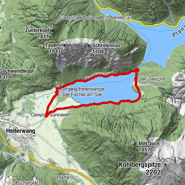
Family hike around lake Heiterwanger See!
- Difficulty
-
easy
- Rating
-
- Starting point
-
Seestrasse parking lot
- Best season
-
JanFebMarAprMayJunJulAugSepOctNovDec
- Description
-
The hike around the lake starts at the Seestraße car park, turn right and follow the forest road along lake Heiterwanger See.
After walking for 5 minutes cross the Grundbach bridge. After 30 minutes you will reach the “Zwirche”, a beautiful bay for swimming and relaxing.
Follow the path towards the canal bridge – and cross there. Then follow the Panoramaweg with spectacular views of the Thaneller mountain to return to your starting point along the other shore of lake Heiterwanger See.
Lake Heiterwanger See lies at 1,000 m above sea level and is 75 m deep at the deepest point. Driving is prohibited around the entire lake. The path on the west bank is wide, not paved and also suitable for a trip with a pram. A narrow path along the east bank invites you to go hiking, Nordic walking and running.
- Directions
-
Keep right from the parking lot. After 5 minutes of walking, cross the Grundbachbrücke. Keep going straight. After 30 minutes of walking you come to the "Zwirche" (beautiful bay for swimming). Then follow the narrow path over the canal bridge. After the bridge, turn left along the west bank towards Heiterwang. At the end of the lake, past the camping site - Hotel Fischer am See the Seestrasse back to the starting point parking lot
- Highest point
- 984 m
- Endpoint
-
Lake Heiterwanger See
- Height profile
-

- Tips
-
Lake Heiterwanger See - Plansee boat trip (mid-May to mid-October)
- Additional information
-
www.zugspitzarena.com
- Directions
-
From Innsbruck
Connections from Innsbruck by car via A12 and B179 (1h 15min - 1h 40min).
- Public transportation
-
OPTION 1:
Connections from Innsbruck Hbf to Garmisch-Partenkirchen (REX and RB – same train; direction Munich-Pasing). Continue from Garmisch-Partenkirchen to Heiterwang-Plansee (RB and R – same train; direction Reutte in Tirol). Short walk to the starting point (13min; 1,1km)
journey duration about 2h 23min
OPTION 2:
Connections from Innsbruck Hbf to Nassereith ÖBB-Postbus Garage (Bus 4176 – direction Nassereith). Continue from Nassereith to Heiterwang Gemeindeamt (Bus 150 – direction Reutte in Tirol). Short walk to the starting point (12min; 1km)
journey duration about 2h 21min
From Munich
Connections from Munich by car via A95 or A96. (2h – 2h 40min)
OPTION 1:
Connections from Munich Hbf to Heiterwang Plansee (RB 5516 – direction Reutte in Tirol). Short walk to the starting point. (13 min; 1,1km) à duration about 3h
OPTION 2: Connections from Munich Hbf to Munich-Pasing (S4 – direction Geltendorf). Continue from Munich-Pasing to Heiterwang Plansee (RB and R – same train; direction Reutte in Tirol). Short walk to the starting point. (13min; 1,1km) journey duration 3h 11min
OPTION 3:
Connections from Munich Hbf to Garmisch-Partenkirchen (RB 5421 – direction Mittenwald). Continue from Garmisch-Partenkirchen to Heiterwang-Plansee (RB 5518 – direction Reutte in Tirol). Short walk to the starting point. (13min; 1,1km)
journey duration 2h 29min
- Parking
-
Parking lot at Seestrasse
- Author
-
The tour Hike at lake Heiterwanger See is used by outdooractive.com provided.


-
Naturparkregion Reutte
1432
-
Heiterwang
361