© TVB Kufsteinerland - Michael Schirnhofer

© TVB Kufsteinerland - Michael Schirnhofer

- Brief description
-
Daytour along the "Adlerweg" - become one with the Kaiser mountain!
- Difficulty
-
medium
- Rating
-
- Starting point
-
Summit station Kaiserlift Kufstein
- Route
-
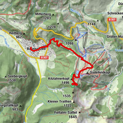
Brentenjoch-Alm0.3 kmKaindlhütte3.0 kmSteinbergkapelle3.1 kmHochegg (1,470 m)4.2 kmJaga Bründl4.7 kmWalleralm5.6 kmStöfflhütte7.5 kmRechau10.5 kmGaisgraben Wasserfall11.3 kmKölnberg-Aussicht11.8 kmKöllenberg11.9 kmHattenhof12.5 kmKohlstatt13.4 kmHubertusquelle13.4 kmLocherer Kapelle13.7 kmHochwacht (661 m)15.5 kmKufstein17.3 kmKienbichl17.3 km
- Best season
-
JanFebMarAprMayJunJulAugSepOctNovDec
- Description
-
From the top station of the Kaiserlift, this tour leads via the Steinberg alms to the "Ridge Walk" power place. Take a look through the "Viscope" at the surrounding mountains before continuing to Walleralm for a delicious Kaspressknödel (flat fried cheese dumplings) soup. The descent back into the valley takes you past Locherer chapel and back to Kufstein.
Starting at the summit station we hike along the alp path to the alp village where we spend a moment to recollect ourselves at the chapel. Afterwards the short ascent to the Hocheck begins. After about one and a half hours we take a rest at the power place "Gratwanderung" and take a look through the telescope to the surrounding mountains. The following descent to the Walleralm takes about one hour. The descent in the valley leads in the direction of Eiberg-Bundesstraße, where we can hop on the bus which takes us back to Kufstein. The second opportunity is to take the route past the "Locherer Kapelle" to the lookout Hochwacht to Kufstein. Afterwards you follow the path along the edge of the city until you reach the Kaiserlift station (takes about 2 hours longer).
- Highest point
- 1,452 m
- Endpoint
-
Valley station Kaiserlift Kufstein
- Height profile
-

- Equipment
-
Outdoor clothing appropriate to the weather (good footwear, rain protection, breathable clothing...)
Snacks (e.g. fruit, muesli bars, wholemeal breads) and drinks (allow for sufficient liquid)
First aid equipment
Mobile phone with full battery
Hiking map and guide literature
Sun protection (sun cream and glasses, cap)
Bivouac bag - Directions
-
Arrival is possible by car to the paid parking lot of the Kaiserlift.
- Public transportation
-
Take the city bus line 1 to the Meraner Straße stop and walk to the valley station.
With the KufsteinerlandCard within the region bus free of charge.
- Parking
-
Talstation Kaiserlift, subject to a charge.


- Author
-
The tour Kaiserlift Tourentipp 3: Walleralm is used by outdooractive.com provided.
GPS Downloads


Other tours in the regions
-
Kufsteinerland
2116
-
Kufstein
567
 und Wasserwand")