- Brief description
-
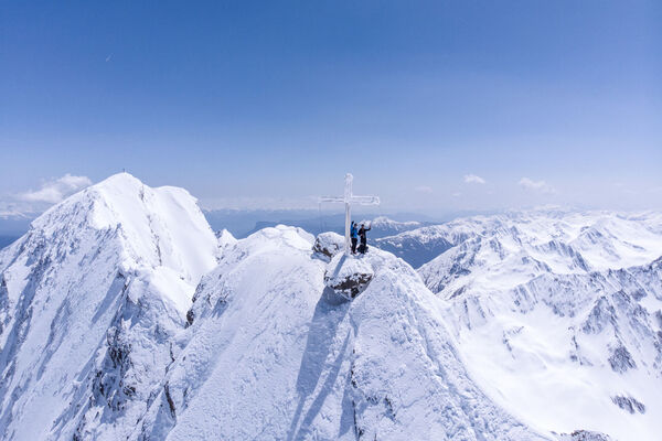
Die angesagteste Steilabfahrt im Obergurgler Tourengebiet.
- Difficulty
-
difficult
- Rating
-
- Route
-
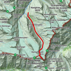
Obergurgl (1,907 m)Hoher First (3,405 m)7.8 kmObergurgl (1,907 m)15.3 km
- Best season
-
AugSepOctNovDecJanFebMarAprMayJunJul
- Description
-
Along the gravel road from Obergurgl south-eastwards to the middle station of Hohe Mut mountain gondola, steep ascent to Gaisbergtal valley. Continue to Gaisbergferner glacier (end of marked hiking route!), keeping to the left on the glacier. A steeply climb path travels up the side moraine on the (orthographic) right side that takes you to the small glacier field of Hochfirstferner. Roping up is absolutely necessary here: follow the northern edge of the glacier (crevasses!) until you get to the peak flank (below), cross the mountain fissure (can be quite challenging if there is no snow!) and ascend on the 45-55 degree steep flank to the rocky but rather easy-to-reach summit of Hochfirst.
- Directions
-
The ski tour to the Hochfirst 3403m offers the alpine touring enthusiast the most challenging steep descent in the tour area of Obergurgl, which can only be compared with the direct northern flank at the Granatenkogel 3318m. Starting in Obergurgl at the base station of the Hohenmuhlbahn 1915m so to the summit to a good 9.0 kilometers not quite 1500 meters of altitude. If you use the Festkogelbahn as an ascent aid and drive to the valley entrance of the Gaisberg valley, the climb is reduced to 6.5 kilometers, or 1100 meters of altitude. In the Gaisbergtal it is first for a long time along the valley floor over mostly rather flat terrain towards the south. The two impressive summits, the Hochfirst, as well as the Liebener peak 3399m, are growing ever more powerful. After entering the Gaisberg, one branches off at Pt. 2700m to the left to reach the Hochfirstferner over a 35 ° to 40 ° steep slope. In the spring, under optimal conditions, it is advantageous to find a compact melting resin here, so that it can easily reach the next higher glacier basin with the aid of a hardening iron and a perfect return technique. The perfect return technique, the Harscheisen maybe less we will need again in the huge north flank of the Hochfirst 3403m. But it is already evident in this first boom that this tour is not only a perfect avalanche and snow conditions, but this tour should be reserved for experienced winter mountain climbers with the necessary skills and know-how. From the Hochfirstferner it is then again at first a pleasant slope up to the edge of the north flank, which has an average inclination of 40 ° at the latest from the edge gap over 200 altitudes and in the steepest passages even to 45 °. At the latest from here you should really only look for an absolutely safe avalanche situation. Once the ski depot has been reached, there is no problem at the Stapf up to the summit. The ridge can also be snow-free. Although there are hardly any climbing difficulties, they are usually crumbling rocks, as well as loose rubble, which are still stored on permafrost soil. On warm days when the soil is thawing, this last upturn can be quite unpleasant. In this case, a rope can be helpful. The following steep slope descends from the skies to the most demanding of what the ski area around Obergurgl has to offer and therefore it would be too late to get to know its ski-boundaries at this time. A boom is certainly not enough here, to get down safely.
- Highest point
- 3,383 m
- Endpoint
-
Obergurgl
- Height profile
-

- Equipment
-
Recommended Ski Mountaineering Equipment
The „standard ski mountaineering equipment“ is: touring skis with touring bindings, telescopic poles, climbing skins, ski crampons, digital avalanche transceiver, avalanche shovel, avalanche probe, firstaid kit and mobile phone. A „complete glacier equipment set“ contains: sit harness, two prusik loops of different lengths and ascenders, two HMS biners, icepick, climbing irons and rope. Pack your rucksack carefully and don‘t forget extra clothes for the descent, sun protection/cream, cold protection, enough food and drink. If you stay overnight at a mountain hut take toiletry articles and a hut sleeping bag with you!
LEVELS OF DIFFICULTY
Easy: Short or moderately long tours, always easy, with ascents not steeper than 25° or slightly steeper only on short sections. Intermediate: Moderately long or long tours of intermediate difficulty with ascents up to 35° or slightly steeper only on short sections. Difficult: Very challenging and long or very long tours with ascents that can exceed 40°, comprising also climbing sections up to difficulty grade II (UIAA). - Safety instructions
-
Avalanche Hazard Scale
1 (LOW)
Triggering is generally possible but only from high additional load in isolated areas of extremely steep terrain. Only small-sized sluffs and natural avalanches are expected. Snow layers are generally stable.
2 (MODERATE)
Avalanches may be triggered in case of truly heavy loads, especially on a few explicitly indicated, steep slopes. Large spontaneous avalanches are not expected. In general, the snowpack is well bonded except on some very steep slopes. Choose your route carefully, avoid the indicated slopes and exposed sections.
3 (CONSIDERABLE)
Triggering is very probable even from low additional loads, particularly on the indicated steep slopes. On some steeper slopes, medium or even fairly large spontaneous avalanches may occur. On most steepslopes the snow layer is only moderately or weakly stable. Expertavalanche knowledge is required. You must avoid the indicated steepslopes and highly exposed sections.
4 (HIGH)
Avalanches are likely to be triggered on many of the indicated steepslopes even if only light loads are applied. In some places, numerous medium-sized and also large-sized natural avalanches are expected.The snowpack is poorly bonded on most steep slopes. Choose your route according to these criteria, select only moderately steep terrain by avoiding the avalanche runout zones. Very expert avalanche knowledge is required.
5 (EXTREMELY HIGH)
Numerous huge or very large-sized natural avalanches are expected also in moderately steep terrain. Safe skiing is not possible anymore, not even in the marked ski area. The snowpack is poorly bonded and largely unstable. Don‘t go ski mountaineering at all!
- Additional information
-
Ski Mountaineering Rules If you enjoy activities amid nature always respect the local guidelines when you set out on a ski tour (for example: wildlife preserves, hunting enclosures, reforestation areas, information boards, etc.). Don‘t enter protected wildlife zones or feeding areas amid naturelandscapes, and avoid noise. Cross forest areas in winter only on sign posted trails or marked routes as wild animals can panic if they hear loud voices or noise. Learn more about the habitat of wild animals in the mountains, avoid getting too close to them. Watch them only from a safe distance. Please put your dog on a lead, it is absolutely irresponsible to take dogs into the forest without leashing them because wild animals suffer from food deficiency and weakness in winter. Excellent planning and time management: start your tour early enough and return before darkness. In spring you should be back on the hut or in the valley at 12 noon (avalanche hazard!) at the latest. Never cross forestation zones and areas with young plants and trees.
Ötztal Tourismus doesn‘t take any responsibility for the suggested tours. It is strongly recommended to enlist a certified local mountainguide. Glacier crossings are allowed only in a group by using a rope.
Before you set out on a tour you should inform someone down in the valley about the tour‘s destination and when you plan to be back. Anavalanche transceiver is an absolute must for Alpine ski mountaineering tours.
More details about ski mountaineering tours in Ötztal: https://www.oetztal.com/skitouren
- Arrival
- Public transportation
- Parking
-
In Obergurgl-Hochgurgl the following parking facilities are available:
- Car park Village center Obergurgl (in front of the church on the right, behind the multi-purpose building where the information office is located)
- Parking lot with coin entrance Parking Place entrance - valley station Festkoglbahn, free of charge
- Parking Hochgurglbahn valley station, free of charge - no parking at night
- Parking Top Mountain Crosspoint, free of charge
- Parking Hochgurgl, free of charge (very small parking)


- Author
-
The tour Hochfirst is used by outdooractive.com provided.


-
Meraner Land
91
-
Passeiertal
49
-
Obergurgl - Hochgurgl
34