
- Brief description
-
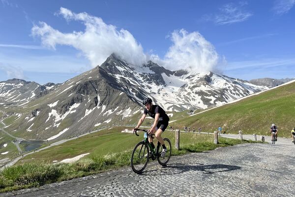
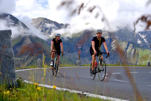
One of the hardest ascents in the Alps – the ride on the Großglockner high alpine road. Speed, views of the glaciers and the feeling that you are sailing across the Alps using pure muscle power, combine to form an inner flight of fancy.
- Difficulty
-
difficult
- Rating
-
- Starting point
-
Kufstein city centre
- Route
-
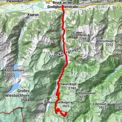
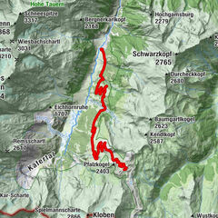
KufsteinEndach1.6 kmEgerbach4.3 kmEgerbach Kapelle4.4 kmGasthof Egerbach4.4 kmEiberg6.0 kmGasthof Oberstegen9.3 kmStockach10.5 kmBocking12.3 kmBlaiken14.0 kmAm Trattenbach14.5 kmOberau14.8 kmNiederachen15.4 kmAuwinkel (742 m)16.3 kmS'Kleine Wirtshaus Ellmau16.3 kmAuwald (749 m)16.6 kmEllmauer Hof17.2 kmSteinerner Tisch (772 m)17.5 kmEllmau18.0 kmGoing20.0 kmDorfwirt20.2 kmReinache23.6 kmBergkapelle25.0 kmRerobichl25.3 kmPizzeria Marco25.9 kmOberndorf in Tirol25.9 kmPfarrkirche Oberndorf26.0 kmDorfwirt26.0 kmHotel Gasthof Neuwirt26.2 kmWalswegen28.7 kmStegerwiese29.4 kmKitzbühel32.2 kmBusiness33.8 kmUnteraurach35.9 kmAuwirt Hotel & Restaurant35.9 kmGrillstation Kebab 9236.4 kmAurach bei Kitzbühel37.0 kmGrill House39.1 kmJochberg41.1 kmPfarrkirche Heiliger Wolfgang41.2 kmAlpenland41.7 kmDorfstub'n Jochberg41.9 kmGasthof Alte Wacht44.0 kmWallfahrtskirche Mariae Heimsuchung46.4 kmWaldwirt46.4 kmPaßthurn52.2 kmHohe Brücke53.3 kmThalbach57.7 kmMittersill59.0 kmBurk60.2 kmStuhlfelden62.8 kmHörfarter63.4 kmPirtendorf63.9 kmUttendorf66.4 kmUggl68.4 kmLengdorf70.7 kmSteindorf72.2 kmNiedernsill72.3 kmWalchen75.9 kmPiesendorf77.9 kmFürth79.3 kmAufhausen81.3 kmLimbergsiedlung81.9 kmFeriengasthof Tauernstüberl82.6 kmBruckberg82.9 kmVorfusch88.5 kmFusch an der Großglocknerstraße94.0 kmHotel-Restaurant Lampenhäusl94.1 kmWasserfall94.1 kmFerleiten100.9 kmSchleierfall101.6 kmKehre 1103.4 kmKehre 2103.8 kmKehre 3104.2 kmPiffalm104.3 kmKehre 4104.6 kmMitteralm105.3 kmGasthof Piffkar105.9 kmKehre 5107.3 kmKehre 6107.6 kmKehre 7108.9 kmKehre 8109.2 kmKehre 9110.5 kmKehre 10110.9 kmHexenküche111.2 kmKehre 11111.3 kmOberes Nassfeld112.5 kmKehre 12113.1 kmKehre 13113.3 kmKehre 14113.7 kmFuscher Törl (2,402 m)114.0 kmTörlkopf (2,455 m)114.2 kmBlick zum Fuscher Törl114.4 kmKehre 15115.9 kmGasthof Fuscherlacke116.2 kmKleines Woazköpfl116.5 kmKehre 16119.5 kmKehre 17119.6 kmHochtor (2,504 m)120.1 kmHochtor (2,576 m)120.3 kmHochtor (2,504 m)120.4 kmMargrötzenhang (2,462 m)121.9 kmMesenaten (2,336 m)122.0 kmMesenaten (2,282 m)122.5 kmAlmwinkl (2,257 m)122.7 kmTauerneck (2,099 m)124.4 kmZlanitzen (2,055 m)124.8 kmZlanitzen (2,037 m)125.0 kmZlanitzen (2,016 m)125.2 kmZlanitzen (1,999 m)125.5 kmKasereck (1,914 m)128.9 kmGasthof Tauernalm131.1 kmFleißtal (1,514 m)132.9 kmFleiß133.4 kmUntere Schütt (1,462 m)133.5 kmWolkersdorf133.8 kmHof135.1 kmHeiligenblut135.2 kmRupertihaus135.3 kmHadergasse135.6 kmMaria-Lourdes-Kapelle136.2 kmMöllfall136.3 kmPockhorn137.7 kmRojach138.5 kmAichhorn139.0 kmGasthaus Gradenwirt142.3 kmPutschall142.4 kmGroßkirchheim144.3 kmDöllach144.5 kmAm Putzenhof145.7 kmWinklsagritz146.2 kmUntersagritz146.7 kmStampfen149.8 kmGasthof Fair150.6 kmMörtschach150.7 kmLassach152.2 kmAuen154.3 kmWinklern157.4 kmTauern Stübel157.4 kmHotel Defregger Hof161.1 kmIselsberg (1,209 m)161.2 kmHotel Iselsbergerhof163.6 kmFilialkirche Hl. Schutzengel163.6 kmIselsberg163.8 kmObergöriach165.8 kmGöriach167.1 kmStribach168.6 kmAlt-Debant169.1 kmKirche zur Heiligen Dreifaltigkeit169.2 kmMühlanger169.5 kmDebant (674 m)169.8 kmGlocknersiedlung170.2 kmLienz173.1 kmSattler Bichl181.2 kmUnterdörfl181.2 kmSattlerwirt181.2 kmAinet (747 m)181.3 kmDornachsiedlung181.4 kmHaiglanger181.6 kmMaria-Hilf-Kapelle187.4 kmSankt Johann im Walde187.6 kmImbiss an der Kalserbachbrücke191.3 kmUnterpeischlach (823 m)191.5 kmKienburg191.7 kmHuben (819 m)192.9 kmHerz Jesu193.3 kmMoos194.5 kmFeldner Katarakt196.1 kmSeblas199.4 kmMatrei in Osttirol201.1 kmSt. Alban201.1 kmKlaunz201.2 kmHinterburg201.5 kmKaltenhaus202.6 kmFelbertauern Stüberl203.8 kmUnterer Steiner Wasserfall204.0 kmGruben207.0 kmBerg (1,272 m)207.5 kmRaneburg (1,268 m)209.7 kmSchildalm214.4 kmTauer216.5 kmBärenköpfe (2,863 m)218.8 kmReiteralm232.0 kmFeldstein237.3 kmFelben238.8 kmBurk239.5 kmMittersill240.1 kmThalbach241.7 kmHohe Brücke246.0 kmPaßthurn247.0 kmWaldwirt253.0 kmWallfahrtskirche Mariae Heimsuchung253.0 kmGasthof Alte Wacht255.4 kmDorfstub'n Jochberg257.8 kmAlpenland257.9 kmPfarrkirche Heiliger Wolfgang258.5 kmJochberg258.5 kmGrill House260.5 kmAurach bei Kitzbühel262.5 kmGrillstation Kebab 92263.0 kmAuwirt Hotel & Restaurant263.3 kmUnteraurach263.7 kmBusiness265.8 kmKitzbühel267.4 kmStegerwiese269.8 kmWalswegen270.7 kmHotel Gasthof Neuwirt273.2 kmOberndorf in Tirol273.3 kmDorfwirt273.4 kmPfarrkirche Oberndorf273.4 kmPizzeria Marco273.5 kmRerobichl274.2 kmBergkapelle274.5 kmReinache275.9 kmDorfwirt278.5 kmGoing279.0 kmEllmau280.5 kmEllmauer Hof281.8 kmSteinerner Tisch (772 m)281.8 kmAuwald (749 m)282.9 kmS'Kleine Wirtshaus Ellmau283.1 kmAuwinkel (742 m)283.1 kmNiederachen283.9 kmOberau284.6 kmAm Trattenbach284.8 kmBlaiken285.4 kmBocking287.0 kmBocking287.2 kmStockach288.8 kmGasthof Oberstegen290.2 kmEiberg293.5 kmGasthof Egerbach295.0 kmEgerbach Kapelle295.1 kmEgerbach295.2 kmEndach297.5 kmKufstein299.5 km
- Best season
-
JanFebMarAprMayJunJulAugSepOctNovDec
- Description
-
The tour starts from Kufstein via Scheffau to Kitzbühel. Continue via Pass Thurn. Now descend to Mittersill, heading to Zell am See and on the flat section to Fusch. Having reached the high alpine road your muscles burn during the continuous 15% gradient. From the summit, proceed on a sharp descent into the valley and less steeply to the Iselsberg Pass, where you’ll climb 300 metres up again. Now down to Lienz in Drautal. Then, 1000 metres of climbing and 30 kilometres later you reach the Felbertauern tunnel. Use the bus shuttle service. After the descent to Mittersill, do the last climb to Pass Thurn. All you have to do now is roll down to Kitzbühel and back to Kufsteinerland.
- Highest point
- 2,804 m
- Endpoint
-
Kufstein city centre
- Height profile
-

- Equipment
-
Cycling helmet, comfortable cycling clothing, change of clothes, wind protection, cycling gloves, possibly rucksack with water bottle and food, first aid equipment, possibly service/repair kit, cycling map, tour description and information material (GPX track), ID card, insurance card, cash
- Directions
-
From the Inntal motorway A12, take the Kufstein Nord exit.
- Public transportation
-
Kufstein main railway station is only a few minutes' walk from the starting point.
- Parking
-
Kufstein centre
- Author
-
The tour 13 - Glockner tour is used by outdooractive.com provided.