

- Brief description
-
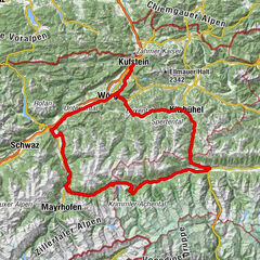
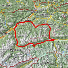
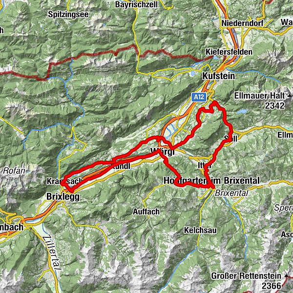
Varied half-day tour round the Pölven with side trips into the Wildschönau and Brixen Valleys and the Sölllandl.
- Difficulty
-
medium
- Rating
-
- Starting point
-
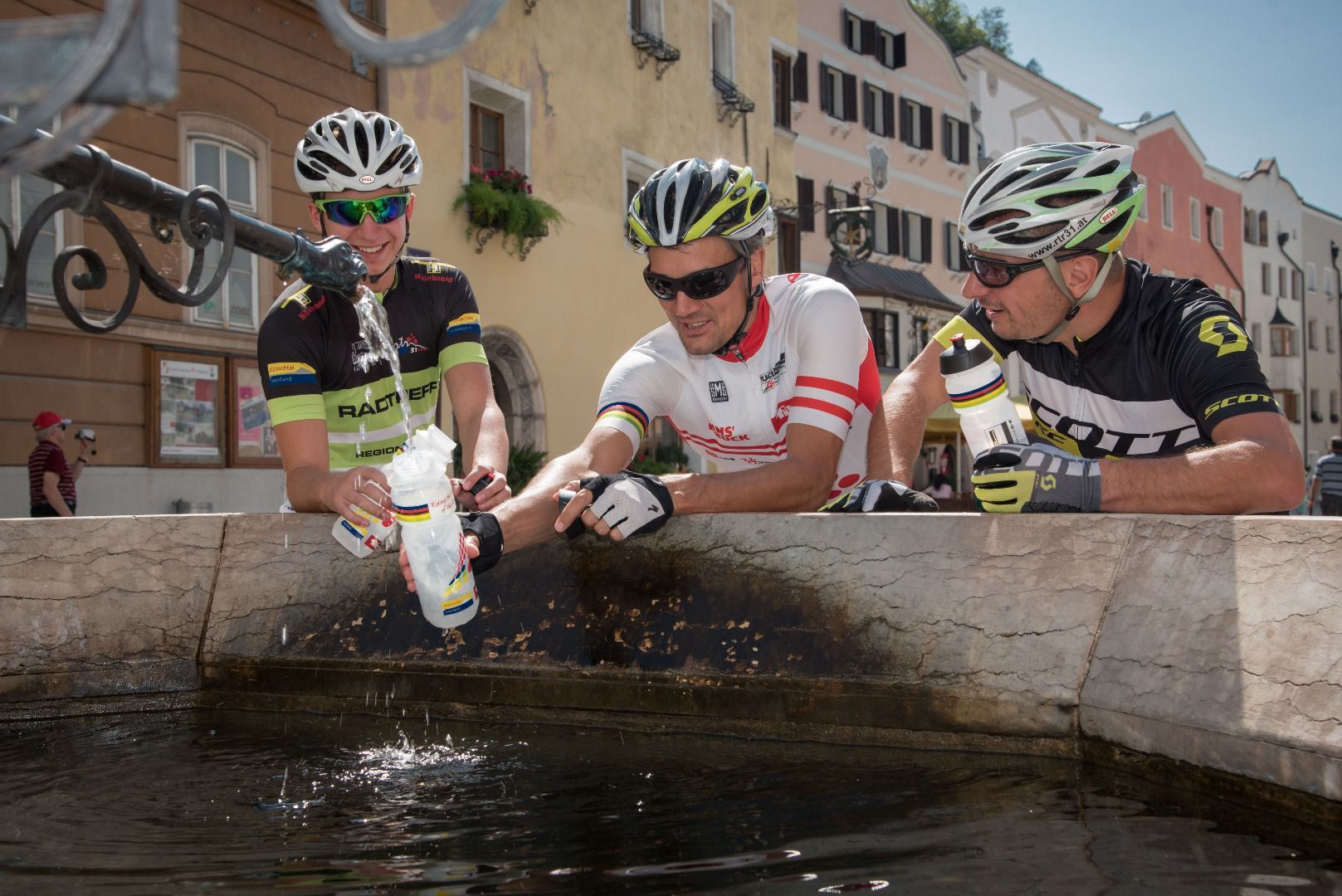
Rattenberg, town main square fountain
- Route
-
RattenbergKlosterkirche hl. Augustinus0.1 kmSpitalkirche0.1 kmRadfeld1.2 kmKapelle St. Leonhard in der Au2.1 kmBreitenbach am Inn7.3 kmWörgl (513 m)16.7 kmHennersberg (718 m)19.7 kmBacherwinkel (734 m)21.9 kmBacherwinkl22.0 kmNiederau (827 m)23.5 kmHeiliger Sixtus und Oswald23.6 kmWeichsölln27.2 kmKühle Luft (595 m)29.8 kmBoden (604 m)30.4 kmHopfgarten im Brixental31.0 kmHopfgarten31.8 kmTirolerhof31.9 kmHeiliger Josef33.8 kmGasthof Itterwirt33.9 kmItter34.1 kmGasthof Kaiserblick36.7 kmPirchmooser-Kapelle39.2 kmPirchmoos39.6 kmSöll40.0 kmDorfbichl40.5 kmGasthof Oberstegen42.2 kmEiberg45.6 kmGasthof Egerbach47.1 kmEgerbach47.2 kmEgerbach Kapelle47.2 kmOsterndorf48.3 kmKapelle Amberg49.0 kmSchwoich50.6 kmKirchenwirt50.7 kmNeuwirt50.7 kmPfarrkirche Heiliger Ägidius50.7 kmMaisfeld51.5 kmHabring54.1 kmLourdeskapelle55.2 kmOsterndorf55.2 kmPfarrkirche Heiliger Johannes der Täufer55.6 kmBad Häring55.8 kmDon Peppe55.9 kmSchönau56.2 kmGasthaus Grattenbrücke59.4 kmWörgl (513 m)59.6 kmBichler's Restaurant & Catering59.9 kmPfarrkirche HeiligerGeist61.5 kmAngath61.5 kmUnholzen63.3 kmGrubers63.5 kmLinden64.0 kmSchulhauskapelle64.2 kmAngerberg64.4 kmFriedenskapelle65.2 kmDorf65.2 kmDorfer Kapelle65.8 kmGlatzham (644 m)67.0 kmKleinsöll (592 m)68.8 kmGattererkapelle68.9 kmGasthaus Krämerwirt69.1 kmStrass (552 m)70.1 kmKriegerdenkmal70.6 kmBreitenbach am Inn70.8 kmPfarrkirche Sankt Petrus70.8 kmAusserdorf71.5 kmAntoniuskapelle72.7 kmHaus (576 m)74.2 kmMoosenkapelle zum Heiligen Josef75.0 kmMosen (582 m)76.2 kmMoosen76.3 kmSeerose77.8 kmFischerstube77.8 kmAchenrain80.0 kmBergfeld80.4 kmZentrum80.6 kmKuglgasse80.7 kmKramsach80.7 kmDreieckkapelle80.9 kmClaudiaplatz80.9 kmUnterkramsach81.1 kmBadl81.5 kmSpitalkirche82.0 kmKlosterkirche hl. Augustinus82.0 kmRattenberg82.1 km
- Best season
-
JanFebMarAprMayJunJulAugSepOctNovDec
- Description
-
TVB Tour 8 – Pölven Runde
Distance 80 km Elevation gain 1250 Gradient up to 10% Best time early summer – late autumn Grading difficult
- Directions
-
Rattenberg – Wörgl – Niederau – Hopfgarten – Itter – Söll – Schwoich – Bad Häring – Angerberg – Breitenbach – Kramsach - Rattenberg
0 km (from the start) start Rattenberg, Notburga fountain short stretch towards Kramsach turn right after 200 m, after a further 800 m keep to the left 7,48 straight Kundl, cross the L 48 after 900 m turn right into the underpass after 100 m turn left and after the wooden bridge left again after 700 m turn left through the underpass and then turn right 11,3 ! left ! Turn-off, turn right after 250 m at the roundabout after 400 m take the 2nd exit Gewerbepark continue along the road to Wörgl 14,8 left Wörgl, rail tracks underpass at the crossroads take the cycle underpass 15,0 right Junction, Martin Pichler Straße continue 600 m along the B 171 15,7 left B 171 junction turn right after 50 m onto the Wildschönauer Straße towards Niederau 6,3 km along the L 3 to Niederau 22 left Niederau, Grafenweg ( L41 ) turn-off 6,8 km to Hopfgarten 28,8 left Hopfgarten, cross the bridge take the rail track underpass turn right after 150 m continue along the road to Hopfgarten over the course of 700 m stay parallel to the B 170 30 right Itterer Straße ( L206 ) turn-off 1,9 km to Itter cycle through Itter 33 !right! Itter, Schwendter Weg turn-off continue along the Schwendter Weg for 2,0 km 35 right Alte Bundesstraße turn-off cycle through the underpass (under the B178) turn right turn left at km 36,1 on the B 178 stay on the cycling path follow the cycling path to Söll 38,4 left Söll, Dorfbichl turn-off 2,2 km via Moorsee to the Eibergstraße 40,6 left Söll / Oberstegen, Eibergstraße ( B173 ) junction continue along the road for 4,9 km 45,5 left Schwoich / Egerbach turn-off continue along the road for 1,9 km via Osterndorf (keep left ) turn right after 1,6 km to Schwoich (church) 49,2 left Schwoich, turn-off 180 m after the church continue along the road for 2,6 km 51,8 right L 208 junction to Bad Häring 2,3 km to Bad Häring via Gasteig continue along the road for 3,5 km 57,6 right Lofererstraße junction turn right after 280 m turn left after 100 m towards Mariastein / Angath ( L213 ) 59,8 straight Angath, continue along the Angerberger Straße 9,0 km along the L 213 and L 211 through Angerberg, Glatzham and Kleinsöll to Breitenbach 69,3 straight Breitenbach, roundabout 2nd exit 8,7 km along the L 211 to Kramsach 78,0 straight Kramsach continue along the road to Rattenberg 80 finish Rattenberg - Highest point
- 884 m
- Endpoint
-
Rattenberg, town main square fountain
- Height profile
-

- Equipment
-
Helmet, sun glasses, gloves, rain proof clothing, bike outfit, first aid kit, replacement inner tube, tire lever, bike pump or cartridge, mobile phone, cash, bank card, drinking bottle, energy gel or bar, cap or bandana, leg and arm warmers.
In any case - equipment should be adapted to the time of year.
- Safety instructions
-
Right-hand traffic in practice. Please obey the highway code, road safety and vehicle rules. Please bear this in mind you'll be sharing roads with traffic.
- Additional information
- Directions
- Public transportation
- Parking
-
By train to Rattenberg train station, by car to one of the parking areas in Rattenberg (east or west).

-

-
AuthorThe tour Road bike 08 Pölven-Tour is used by outdooractive.com provided.


General info
-
Wildschönau
42
-
Wörgl
15