
- Brief description
-
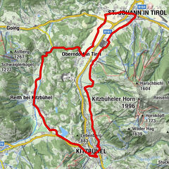
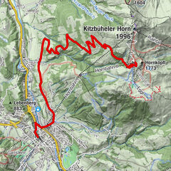
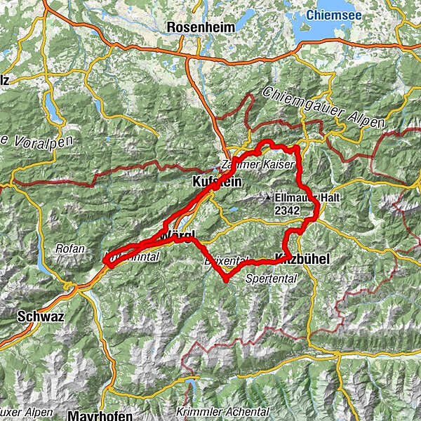
The challenging tour leads through the Kaiser range with its striking scenery and fast descents; ideal for racing fans. This tours route also avoids busy main roads.
- Difficulty
-
medium
- Rating
-
- Starting point
-
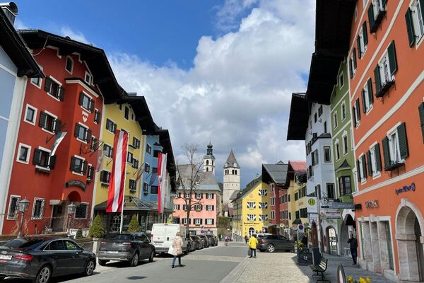
Rattenberg, town main square fountain
- Route
-
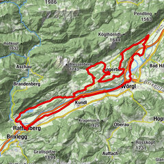
RattenbergKlosterkirche hl. Augustinus0.1 kmSpitalkirche0.1 kmRadfeld1.2 kmKapelle St. Leonhard in der Au2.2 kmBreitenbach am Inn7.4 kmWörgl (513 m)15.1 kmTaufkapelle15.8 kmStadtpfarrkirche Hl. Laurentius15.8 kmMayrhofen (529 m)18.0 kmWörgler Boden (535 m)19.1 kmBruckhäusl (534 m)19.3 kmPinnersdorfer Kapelle20.0 kmPinnersdorf (554 m)20.2 kmHaus (571 m)20.9 kmHauserwirt21.0 kmHerz-Jesu-Kapelle21.1 kmGrieswirt22.9 kmTirolerhof24.6 kmHopfgarten24.7 kmKühle Luft (595 m)25.3 kmHopfgarten im Brixental25.3 kmBoden (604 m)26.2 kmElsbethen (611 m)26.5 kmHaslau (613 m)26.7 kmUnterwindau30.6 kmLendwirt30.8 kmHolzham33.1 kmWestendorf33.9 kmPfarrkirche zum Heiligen Nikolaus33.9 kmBichling35.1 kmBrixen im Thale37.1 kmLauterbach38.5 kmFeuring39.4 kmKirchberg in Tirol43.0 kmHeiliger Ulrich von Augsburg43.1 kmKlausen-Kapelle45.1 kmSchwedenkapelle45.1 kmMünichau47.6 kmSchloss Münichau47.6 kmMünichau47.7 kmReith bei Kitzbühel49.0 kmReinache52.8 kmBergkapelle54.2 kmRerobichl54.5 kmPizzeria Marco55.1 kmOberndorf in Tirol55.2 kmDorfwirt55.2 kmPfarrkirche Oberndorf55.2 kmEberhartling56.3 kmSperten57.5 kmWeitau58.8 kmSt. Johann in Tirol59.9 kmNarzen61.5 kmMitterjager64.9 kmGasteig64.9 kmGut Kramerhof65.2 kmRupertsau66.4 kmTeufelskapelle67.4 kmGasthof Griesenau68.3 kmGriesenau68.3 kmHohenkendl71.0 kmKohlental71.5 kmBichlkapelle72.5 kmNiederbichl77.1 kmRiedl77.2 kmWalchsee82.5 kmSchwaigs (664 m)84.9 kmGolf- u. Sporthotel Moarhof85.2 kmPötting (646 m)86.8 kmAsching90.3 kmRuapen Kapelle92.0 kmKruckwasserfall92.9 kmMariae Himmelfahrt94.8 kmEbbs94.8 kmOberndorf96.4 kmSattlerwirt96.4 kmGasthof Schanz97.6 kmWeinstadl100.1 kmSparchen100.8 kmUntere Sparchen100.8 kmKufstein102.2 kmStadtpfarrkirche Heiliger Vitus102.5 kmMitterndorf102.9 kmZell104.3 kmMorsbach105.5 kmTiroler Fliegerstube107.5 kmSchaftenau (510 m)109.1 kmUnterlangkampfen (502 m)110.3 kmNiederbreitenbach (519 m)112.2 kmGasthof Dampflwirt112.4 kmNotburgakapelle112.6 kmBrand114.4 kmGasthof Kammerhof114.9 kmMariastein115.1 kmWallfahrtskirche Mariastein115.1 kmAngerberg118.1 kmFriedenskapelle118.6 kmDorf118.7 kmDorfer Kapelle119.3 kmGlatzham (644 m)120.5 kmGattererkapelle122.3 kmKleinsöll (592 m)122.3 kmGasthaus Krämerwirt122.4 kmStrass (552 m)123.6 kmKriegerdenkmal124.1 kmBreitenbach am Inn124.2 kmPfarrkirche Sankt Petrus124.4 kmAusserdorf125.0 kmAntoniuskapelle126.2 kmHaus (576 m)127.7 kmMoosenkapelle zum Heiligen Josef128.5 kmMosen (582 m)129.7 kmMoosen129.8 kmSeerose131.2 kmFischerstube131.3 kmAchenrain133.5 kmBergfeld133.9 kmZentrum134.1 kmKramsach134.2 kmKuglgasse134.2 kmDreieckkapelle134.3 kmClaudiaplatz134.4 kmUnterkramsach134.6 kmBadl135.0 kmSpitalkirche135.5 kmKlosterkirche hl. Augustinus135.5 kmRattenberg135.5 km
- Best season
-
JanFebMarAprMayJunJulAugSepOctNovDec
- Description
-
TVB Tour 02 – around the Wilder Kaiser
Distance 135 km Elevation gain 1220 m Gradient Max. 9 % Best time early summer - autumn Grading challenging - Directions
-
Rattenberg – Wörgl – Westendorf – Kirchberg – St. Johann – Schwendt/Bichlach – Walchsee – Buchberg – Ebbs – Kufstein – Mariastein – Breitenbach – Kramsach - Rattenberg
0 km (from the start) start Rattenberg, Notburga fountain short distance to Kramsach turn right after 200 m, then turn left after a further 800 m 7,48 straight Kundl, cross the L 48 turn right after 900 m into the underpass after 100 m turn left and after the wooden bridge left again turn left after 700 m through the underpass and then turn right 11,3 ! left ! Turn-off, turn right after 250 m after 400 m at the roundabout 2nd exit Gewerbepark continue on to Wörgl 14,8 left Wörgl, rail tracks underpass at the crossroads take the cyclists underpass 15,0 right Martin Pichler Straße junction after 600 m follow the B 171 15,7 left B 171 junction turn right after 200 m (church) into the Brixentaler Straße 3,6 km to Bruckhäusl 20,1 straight Pinnersdorf continue on for 2,7 km 22,8 straight Hopfgarten/Weiler Gries after the rail tracks underpass along a 1,4 km stretch take the B 170 by-road 24,2 left Hopfgarten underpass turn right after the underpass and take the road running parallel to the B 170 through Hopfgarten 25,8 left Kitzbühel junction 1,6 km along the B 170 27,1 right Turn-off after the underpass 3,4 km to Unterwindau turn left at the Gasthof Lendwirt, 3,1 km to Westendorf 34,2 straight Westendorf (church) turn half-right after 240 m onto the Bichlinger Straße 8,5 km via the Radweg to Kirchberg 42,7 right Kirchberg, turn-off Dorfstraße turn left after 140 m to the roundabout 1st exit follow the Kitzbüheler Straße over 1,4 km continue along the B 170 for 2,4 km 46,5 left Turn-off to Reith b. Kitzbühel along the L 202 6,3 km through Reith bei Kitzbühel 52,8 right Turn-off into the Rerobichl Straße 2,4 km to Oberndorf 55,2 left Oberndorf, turn-off to St. Johann turn left after 850 m and after 100m turn right 2,2 km to Weitau/St. Johann keep right for 1,4 km up to the roundabout 59,6 left St. Johann, roundabout 3rd exit 800 m along the B 178 60,4 left Turn-off Kössener Straße B 176 11,7 km to Kössen 72,1 ! left ! Turn-off onto the cyclist path (Bichlachweg) turn left after 4,4 km turn left again after a further 370 m to Oberbichlach 3,3 km along the Radweg Kufstein/Erl 80,0 left Walchsee, B 172 junction 2,8 km to Walchsee, then turn right to Rettenschöss continue to km 86,1 then turn right and left at the next crossroads 2,4 km to Aufing and on to the B 172 88,6 right Durchholzen, B 172 junction turn half-left after 270 m on to the B 172 to Buchberg at km 91,4 keep left and via St. Nikolaus to Ebbs 94,7 left Ebbs, B 175 junction 4,6 km to Kufstein/ Eichelwang, turn left at km 99,3 3,7 km to Kufstein 103,1 right Roundabout 1st exit to Kiefersfelden 800 m along the B171 103,9 left Kufstein/Zell, turn-off to Mariastein continue along the road for 4,8 km 108,7 right Unterlangkampfen, turn-off Obere Dorfstraße 7,6 km to Unterlangkampfen, Niederbreitenbach and Mariastein a further 7,9 km along the L 211 to Breitenbach 123,8 straight Breitenbach, roundabout 2nd exit passing Lake Reintal continue on to Kramsach 132,5 straight Kramsach / Achenrain continue on to Rattenberg 135,2 finish Rattenberg - Highest point
- 824 m
- Endpoint
-
Rattenberg, town main square fountain
- Height profile
-

- Equipment
-
Helmet, sun glasses, gloves, rain proof clothing, bike outfit, first aid kit, replacement inner tube, tire lever, bike pump or cartridge, mobile phone, cash, bank card, drinking bottle, energy gel or bar, cap or bandana, leg and arm warmers.
In any case - equipment should be adapted to the time of year.
- Safety instructions
-
Right-hand traffic in practice. Please obey the highway code, road safety and vehicle rules. Please bear this in mind you'll be sharing roads with traffic.
- Additional information
- Directions
-
A12 motorway - exit Kramsach/Alpbachtal, turn left towards Brixlegg/Rattenberg, take the thrid exit at the roundabout, after 400m parking (subject to charges)
- Public transportation
- Parking
-
By train to Rattenberg-Kramsach train station, by car to one of the both parking-areas to both ends of the town
-

-
AuthorThe tour Road bike 02 Wilder Kaiser Loop is used by outdooractive.com provided.
General info
-
Kufsteinerland
50
-
Söll
13