
- Brief description
-
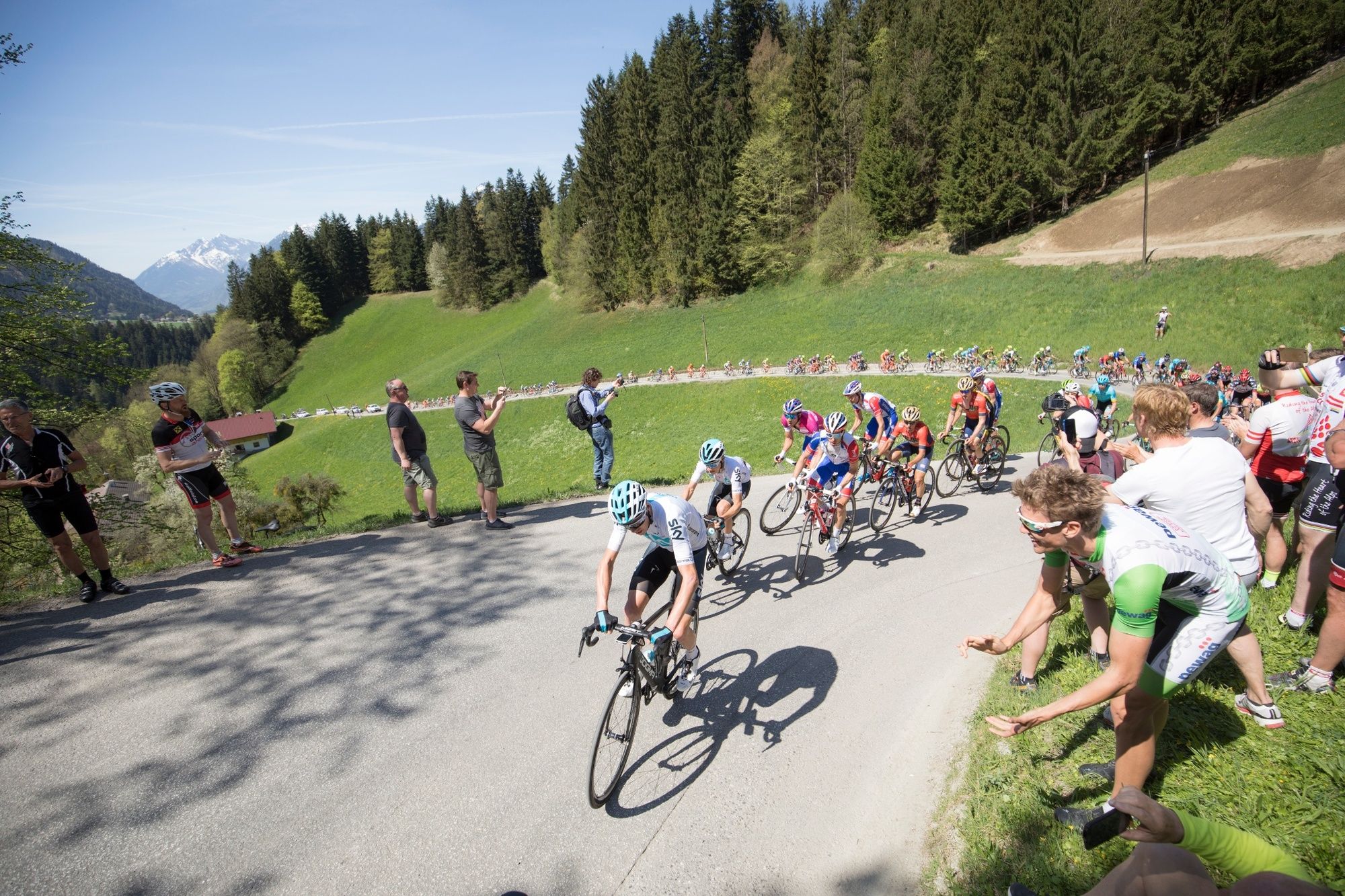
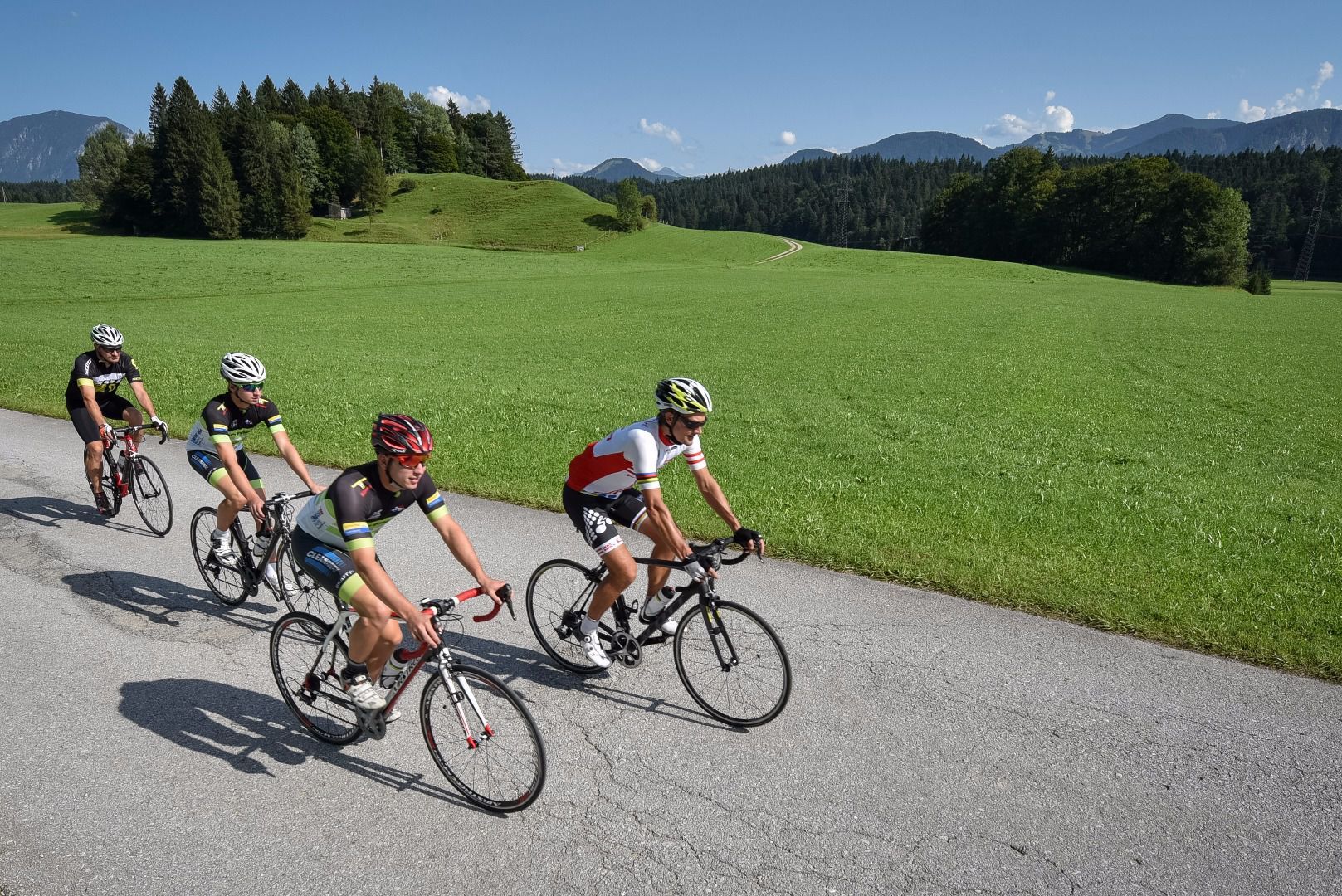
A challenging road-cycle-tour through the Alpbachtal & Tiroler Seenland region. This varied tour with great descents is far away from highly frequented transit routes.
- Difficulty
-
difficult
- Rating
-
- Starting point
-
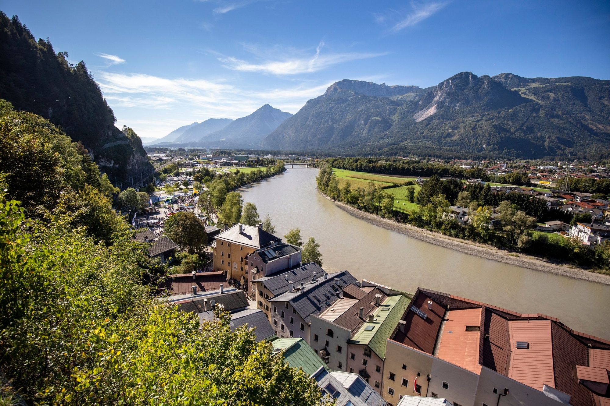
Rattenberg, town main square fountain
- Route
-
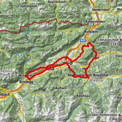
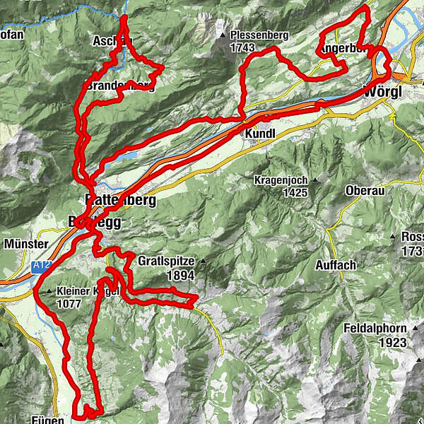
RattenbergKlosterkirche hl. Augustinus0.1 kmSpitalkirche0.1 kmRadfeld1.2 kmKapelle St. Leonhard in der Au2.1 kmBreitenbach am Inn7.4 kmWörgl (513 m)14.3 kmSchlöglhofkapelle16.2 kmAngath16.9 kmPfarrkirche HeiligerGeist17.0 kmUnholzen18.8 kmGrubers18.9 kmBaumgarten-Kapelle19.2 kmGasthof Baumgarten19.3 kmBaumgarten19.4 kmStrass20.1 kmMariastein21.2 kmMariasteinerhof21.2 kmEndstrass24.9 kmDorf26.2 kmFriedenskapelle26.3 kmGlatzham (644 m)29.4 kmSchönau (593 m)31.7 kmOberdorf35.4 kmKriegerdenkmal35.9 kmPfarrkirche Sankt Petrus36.2 kmBreitenbach am Inn36.2 kmAusserdorf36.9 kmAntoniuskapelle38.1 kmHaus (576 m)39.6 kmMoosenkapelle zum Heiligen Josef41.1 kmMosen (582 m)41.6 kmMoosen41.6 kmSeerose43.1 kmFischerstube43.2 kmAchenrain45.2 kmKramsach45.3 kmEbnat45.7 kmBrandenberg52.0 kmAscherwirt52.0 kmHeiliger Georg52.1 kmNeuwirt52.1 kmHachakapelle56.2 kmNeue Kapelle Pinegg58.4 kmGasthof Gwercherwirt58.6 kmKapelle Pinegg58.8 kmPinegg58.9 kmAschau60.6 kmMariatal (533 m)69.3 kmRadetzkyweg69.5 kmLiftstüberl69.5 kmEbnat69.9 kmWittberg (526 m)70.2 kmLändbühel70.7 kmKramsach70.8 kmAmerling70.9 kmHagau (517 m)71.8 kmBrixlegg74.0 kmWeng (526 m)74.6 kmRestaurant Gut Matzen75.4 kmLichtwerth (529 m)75.9 kmFilialkirche St. Gertraudi76.9 kmSankt Gertraudi (527 m)76.9 kmLandhauskapelle78.6 kmBruck am Ziller (579 m)80.1 kmPfarrkirche Bruck80.2 kmGasthof Dorfwirt80.2 kmImming81.5 kmPizzeria La Strada85.8 kmGasthof Hamberg86.1 kmHart im Zillertal (666 m)87.0 kmSpielplatz/Wöxlkreuz87.7 kmMariä Reinigung90.4 kmGasthof Steinerhof93.0 kmKerschbaumer Sattel (1,113 m)93.7 kmRosenkranz Kapelle94.9 kmGschwendt Almstüberl95.9 kmKapelle Maria vom Guten Rat97.6 kmHygna (817 m)97.6 kmAlpbach (975 m)104.9 kmSterzn Kapel107.9 kmAchleitn Kapelle108.6 kmKöckn Kapelle109.9 kmAlpsteg (619 m)111.6 kmBischofsbrunn112.2 kmReith im Alpbachtal (638 m)112.7 kmDekanatspfarrkirche St. Petrus112.8 kmSonnbichl113.3 kmMehrn (560 m)114.3 kmBrixlegg115.0 kmRattenberg117.0 km
- Best season
-
JanFebMarAprMayJunJulAugSepOctNovDec
- Description
-
Road bike tour 01 – Giro Alpbachtal
Distance 116 km Elevation gain 2250 hm Gradient 600 m 18 %, the rest up to 12 % Best time early spring – late autumn Grading very hard
- Directions
-
Rattenberg – Alpbach – Kerschbaum – Bruck – Brixlegg – Kramsach – Aschau – Pinegg – Brandenberg – Kramsach – Breitenbach - Angerberg – Angath – Wörgl - Rattenberg
0 Km (from the start) start Rattenberg, Notburga fountain westwards to Brixlegg along the B 171, roundabout 3rd exit 2,1 left Brixlegg, roundabout 2nd exit L 5 to Alpbach 1,4 km along the L 5, at Reith Nord towards the centre 4,0 ! left ! Reith im Alpbachtal, turn-off turn left immediately after the archway after 450 m cross the L 5 take the first turn to the right and then the next left, continue for 860 m to Alpbach 5,4 straight Bridge across the Alpbach River turn right after 750 m, continue along 5,9 via the Scheffachberg, Naschberg and Außerland to Alpbach 12 right Alpbach, L 46 junction 750 m along the L46, then turn right onto the L 5 5,1 km along the L 5 to Reith im Alpbachtal Return via Reith to Rattenberg 17,9 ! left ! Reith, turn right towards Hygna after 1,3 km keep to theright, cycle a further 3,7 km to the Kerschbaumsattel 22,9 straight Kerschbaumer Sattel, 2,4 km to Bruck/Säulinger Hof 25,3 left Bruck/Säulinger Hof, turn-off 4,2 km to the „Panoramastraße“ direction Hart i. Zillertal 29,5 straight Hart i. Zillertal, junction 1,4 km to Niederhart 30,9 ! right! Turn-off on to the Ziller road 7,2 km to Bruck/Imming and in Bruck onto the B 171 38,1 right B 171 junction 4,2 km to Brixlegg 42,3 straight Brixlegg, roundabout 2nd exit turn left after 60 m to Münster turn left after 600 m and crossing a bridge and continue along the road 44,1 right Kramsach Hagau, L 211 junction 1,53 km to a roundabout 2nd exit turn left after 60 m to Brandenberg follow the L 211 for 700 m 46,4 left Turn-off to Aschau 9,5 km to Aschau 55,9 right Aschau, L 4 junction 8,6 km along the L 4 to Brandenberg 64,5 straight Brandenberg, church 6,7 km along the L 4 to Kramsach 71,2 ! left ! Kramsach Achenrain 8,7 km along the L 211 to Breitenbach Breitenbach roundabout, Return via the Innradweg to Rattenberg 79,9 straight Breitenbach, roundabout 2nd exit straight ahead after 460 m 4,3 km to Schönau turn right 2,37 km to Glatzham 87,0 straight Breitenbach/Glatzham Cross the L 211 straight after 2,0 km turn left after a further 460 m left again continue for 2,6 km (crossing the L 211 after 500m) 92,1 ! right! Embach, turn-off 2,5 km to Mariastein 94,6 right Mariastein, turn-off 2,4 km to Baumgarten 97,0 left Baumgarten, L 213 junction 2,7 km to Angath 99,7 right Turn-off onto the Libhartstraße to Wörgl 1,8 km 101,5 right Nordtangente Wörgl junction 2,5 km through the Gewerbepark 3rd exit at the roundabout, turn left after 400 m 104,7 right Turn-off to Kundl after 550 m straight along the „Innradweg“ to Rattenberg 116 finish Rattenberg - Highest point
- 1,107 m
- Endpoint
-
Rattenberg, town main square fountain
- Height profile
-

- Equipment
-
Helmet, sun glasses, gloves, rain proof clothing, bike outfit, first aid kit, replacement inner tube, tire lever, bike pump or cartridge, mobile phone, cash, bank card, drinking bottle, energy gel or bar, cap or bandana, leg and arm warmers.
In any case - adapted to the time of year.
- Safety instructions
-
Right-hand traffic in practice. Please obey the highway code, road safety and vehicle rules. Please bear this in mind you'll be sharing roads with traffic.
- Tips
-
Right-hand traffic in practice. Please obey the highway code, road safety and vehicle rules. Please bear this in mind you'll be sharing roads with traffic.
- Additional information
- Directions
- Public transportation
- Parking
-
By train to Rattenberg train station, by car to one of the parking areas in Rattenberg (east or west).

-

-
AuthorThe tour Road bike 01 Giro Alpbachtal is used by outdooractive.com provided.