© Tourismusverband WILDER KAISER - Katharina Schörghofer


- Difficulty
-
easy
- Rating
-
- Starting point
-
in the centre of Ellmau
- Route
-
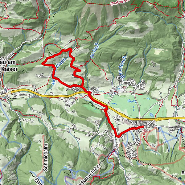
Ellmau0.1 kmPfarrkirche0.1 kmAu (806 m)0.6 kmSteinerner Tisch (772 m)1.8 kmEllmauer Hof2.2 kmBuchau (757 m)3.3 kmÖtting5.0 kmMittersbach5.1 kmLandhotel Föhrenhof6.5 kmFöhrenhof6.7 kmAuwald (749 m)6.7 kmEllmauer Hof7.6 kmSteinerner Tisch (772 m)8.1 kmAu (806 m)9.1 kmPfarrkirche9.6 kmEllmau9.8 km
- Description
-
You’ll start this tour at the Dorfpark in Ellmau. Pass the church and walk/ run towards Gasthof Au. Immediately after the Gasthof Au, turn right and follow this road next to river Weißach until the Ellmauer Hof. At the Ellmauer Hof take the underpass to the right and follow the sign to the Haflingertränke alpin guest house. When you reach the Haflingertränke, take a break or run/ walk up a short hill, turn left through some forest. Turn left at the crossroads and walk/ run towards Auwald, cross the part called Auwlad and run/ walk back to the center of Ellmau.
- Highest point
- 927 m
- Height profile
-

- Parking
-
public parking in the centre of Ellmau


- Author
-
The tour Lamarunde Ellmau is used by outdooractive.com provided.
GPS Downloads


Other tours in the regions
-
Wilder Kaiser
122
-
Ellmau
67
Sportalpen Marketing")