© TVB Wilder Kaiser - TVB Wilder Kaiser/Andreas Handl

© TVB Wilder Kaiser - TVB Wilder Kaiser/Andreas Handl

© TVB Wilder Kaiser - TVB Wilder Kaiser/Andreas Kranzmayr

© TVB Wilder Kaiser - TVB Wilder Kaiser/Mathäus Gartner

© TVB Wilder Kaiser - TVB Wilder Kaiser/Mathäus Gartner

© TVB Wilder Kaiser - TVB Wilder Kaiser/Mathäus Gartner

© TVB Wilder Kaiser - TVB Wilder Kaiser/Andreas Handl

© TVB Wilder Kaiser - TVB Wilder Kaiser/Andreas Kranzmayr

© TVB Wilder Kaiser

© TVB Wilder Kaiser

- Brief description
-
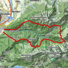
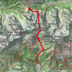
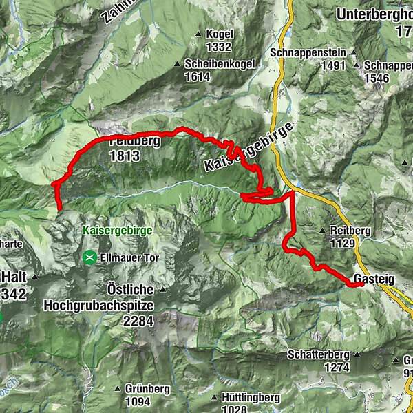
Stripsenjochhaus – Stripsenkopf – Feldberg – Scheibenbichlalmen – Griesenau – Gasteig
- Difficulty
-
medium
- Rating
-
- Starting point
-
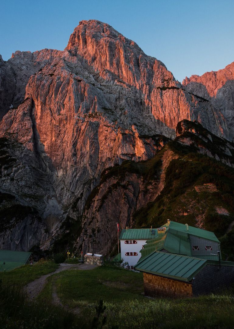
Stripsenjochhaus, St. Johann in Tirol (1,577 m)
- Route
-
Stripsenjochhaus0.0 kmHundskopf (1,730 m)0.5 kmStripsenkopf (1,807 m)1.1 kmTristecken (1,702 m)2.2 kmFeldberg (1,813 m)3.0 kmWasserlahnerkopf (1,609 m)4.1 kmSchneebichl (1,470 m)5.8 kmGriesenau12.0 kmGut Kramerhof16.1 kmGasteig16.1 km
- Best season
-
JanFebMarAprMayJunJulAugSepOctNovDec
- Description
-
Imposing views from the Wilder Kaiser to Chiemsee lake!
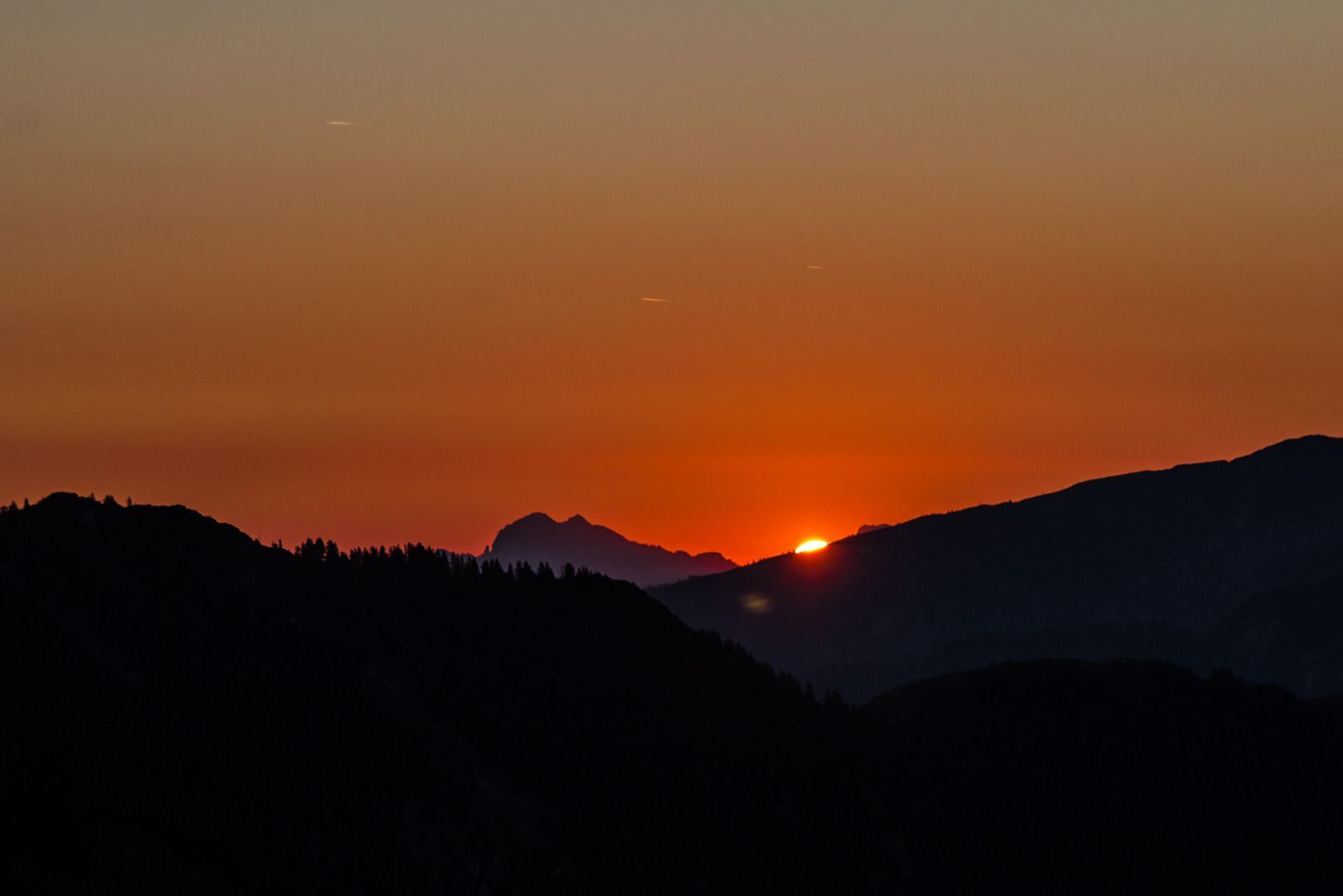
At the Stripsenjochhaus mountain hut, you can also enjoy the wonderful colours of nature that accompany the sunrise!
Take path 825 and head north via a ridge that is overgrown with mountain pines. At the Feldberg/Stripsenkopf turnoff, keep right and head in the direction of Feldberg. When you reach the next turnoff, walk west for around 10-15 minutes until you come to the viewing pavilion of the Stripsenkopf mountain (1,807 m). This is an excellent place to enjoy the full might of the summits and rock faces in the Wilder Kaiser region! On a clear day, you can even see as far as Chiemsee lake in the north, the Loferer and Leoganger Steinberge mountains to the south and the Karwendel mountains as you look west.
Continue along the panoramic ridge, first heading downhill and past the “Frankenländer Nadel” formation. Then walk back uphill via the Tristecken (1,710 m) to the Feldberg summit (1,813 m). This offers a fascinating view into the Ellmauer Tor from the north.
Path 825 continues up to the Obere Scheibenbichlalm Alpine pasture. Here, you will follow forest road 76 and certain sections of trail 20 (shortcuts across meadows and through the forest) as you head down into the Kaiserbachtal valley nature reserve.
Once you reach the asphalt road, hike east. If the water level is low, you can cross the stream after around 100 metres and follow forest road 801 towards Griesenau. If the water level is too high, simply follow the asphalt road past the toll point as it guides you to Griesenau.
Here, the Gasthof Griesenau inn welcomes tired and hungry hikers.
If you still have the energy reserves to reach the end of this stage, you should turn off before Kössener Strasse. Bear right onto the forest road when you come to the first house and walk south along the Engelbach stream towards Gasteig (around 1 to 1.5 hours). At the first fork in the road, keep left. The trail leads over a series of wooden steps, passing through the forest until you come back to the forest road. You should then keep following this southeast until you reach Gasteig, which features a range of options for overnight stays.
Make sure to take sufficient food and drinks with you on this stage!
Tip: Postbus and show dairy
Tired hikers can use the public bus service 4000 to complete the final part of their journey from Griesenau to Gasteig, where they can visit the “Wilder Käser” show dairy. - Directions
-
Imposing views from the Wilder Kaiser to Chiemsee lake!
At the Stripsenjochhaus mountain hut, you can also enjoy the wonderful colours of nature that accompany the sunrise!
Take path 825 and head north via a ridge that is overgrown with mountain pines. At the Feldberg/Stripsenkopf turnoff, keep right and head in the direction of Feldberg. When you reach the next turnoff, walk west for around 10 minutes until you come to the viewing pavilion of the Stripsenkopf mountain (1,807 m). This is an excellent place to enjoy the full might of the summits and rock faces in the Wilder Kaiser region! On a clear day, you can even see as far as Chiemsee lake in the north, the Loferer and Leoganger Steinberge mountains to the south and the Karwendel mountains as you look west.
Continue along the panoramic ridge, first heading downhill and past the “Frankenländer Nadel” formation. Then cross the Wiesensattel (1,627 m) and walk back uphill via the Tristecken (1,710 m) to the Feldberg summit (1,813 m). This offers a fascinating view into the Ellmauer Tor from the north.
Path 825 continues up to the Obere Scheibenbichlalm Alpine pasture. Here, you will follow forest road 76 and certain sections of trail 20 (shortcuts across meadows and through the forest) as you head down into the Kaiserbachtal valley nature reserve.
Once you reach the asphalt road, hike east. If the water level is low, you can cross the stream after around 100 metres and follow forest road 801 towards Griesenau. If the water level is too high, simply follow the asphalt road past the toll point as it guides you to Griesenau.
Here, the Gasthof Griesenau inn welcomes tired and hungry hikers with its excellent trout and rooms with a view of the inn’s own water lily pond.
If you still have the energy reserves to reach the end of this stage, you should turn off before Kössener Strasse. Bear right onto the forest road when you come to the first house and walk south along the Engelbach stream towards Gasteig (around 1 to 1.5 hours). At the first fork in the road, keep left. The trail leads over a series of wooden steps, passing through the forest until you come back to the forest road. You should then keep following this southeast until you reach Gasteig, which features a range of options for overnight stays.
Make sure to take sufficient food and drinks with you on this stage!
Tip: Postbus and show dairy
Tired hikers can use the Postbus service to complete the final part of their journey from Griesenau to Gasteig, where they can visit the “Wilder Käser” show dairy. To find the opening times and the timetable for the Postbus 4000 route, visit www.wilderkaiser.info/en/summer-holiday/destination-tyrol/die-kaiserkrone.html - Highest point
- 1,801 m
- Endpoint
-
Gasteig (750 m)
- Height profile
-

- Equipment
-
Rucksack, sturdy hiking/mountaineering boots with anti-slip treaded soles, weather-appropriate hiking gear (breathable), a change of clothes, sun protection (sunglasses, sun cream, lip protection, headgear), waterproofs (rain jacket/poncho, pocket umbrella, rucksack protector), cold protection (hat, gloves), sufficient food and drink, hiking poles (height adjustable) if required, first aid kit incl. rescue blanket and bivouac sack, mobile phone with fully charged battery, headlamp, plastic bag for waste, hiking map, route description and information materials (GPX track), ID, insurance card, cash
Additions for overnight stay at mountain hut:
Mountain hut sleeping bag, indoor shoes, toiletries and towel, personal medication, headlamp, Alpine Club ID Card, cash, charger for mobile phone
The hiking routes between the huts are often rather long, we recommend taking plenty of food and drink and booking your overnight stays well in advance. - Directions
-
Imposing views from the Wilder Kaiser to Chiemsee lake!
At the Stripsenjochhaus mountain hut, you can also enjoy the wonderful colours of nature that accompany the sunrise!
Take path 825 and head north via a ridge that is overgrown with mountain pines. At the Feldberg/Stripsenkopf turnoff, keep right and head in the direction of Feldberg. When you reach the next turnoff, walk west for around 10 minutes until you come to the viewing pavilion of the Stripsenkopf mountain (1,807 m). This is an excellent place to enjoy the full might of the summits and rock faces in the Wilder Kaiser region! On a clear day, you can even see as far as Chiemsee lake in the north, the Loferer and Leoganger Steinberge mountains to the south and the Karwendel mountains as you look west.
Continue along the panoramic ridge, first heading downhill and past the “Frankenländer Nadel” formation. Then cross the Wiesensattel (1,627 m) and walk back uphill via the Tristecken (1,710 m) to the Feldberg summit (1,813 m). This offers a fascinating view into the Ellmauer Tor from the north.
Path 825 continues up to the Obere Scheibenbichlalm Alpine pasture. Here, you will follow forest road 76 and certain sections of trail 20 (shortcuts across meadows and through the forest) as you head down into the Kaiserbachtal valley nature reserve.
Once you reach the asphalt road, hike east. If the water level is low, you can cross the stream after around 100 metres and follow forest road 801 towards Griesenau. If the water level is too high, simply follow the asphalt road past the toll point as it guides you to Griesenau.
Here, the Gasthof Griesenau inn welcomes tired and hungry hikers with its excellent trout and rooms with a view of the inn’s own water lily pond.
If you still have the energy reserves to reach the end of this stage, you should turn off before Kössener Strasse. Bear right onto the forest road when you come to the first house and walk south along the Engelbach stream towards Gasteig (around 1 to 1.5 hours). At the first fork in the road, keep left. The trail leads over a series of wooden steps, passing through the forest until you come back to the forest road. You should then keep following this southeast until you reach Gasteig, which features a range of options for overnight stays.
Make sure to take sufficient food and drinks with you on this stage!
Tip: Postbus and show dairy
Tired hikers can use the Postbus service to complete the final part of their journey from Griesenau to Gasteig, where they can visit the “Wilder Käser” show dairy. To find the opening times and the timetable for the Postbus 4000 route, visit www.wilderkaiser.info/en/summer-holiday/destination-tyrol/die-kaiserkrone.html - Public transportation


- Author
-
The tour Kaiserkrone - stage 4 is used by outdooractive.com provided.
GPS Downloads


General info
Refreshment stop
Flora
Fauna
A lot of view
Other tours in the regions
-
Kaiserwinkl
1884
-
Schwendt
463