- Brief description
-
The Rhön is a low mountain range full of legends and myths. The highlight of this route is the so-called linden tree "Hexenlinde", which received its name through one of these tales.
- Difficulty
-
easy
- Rating
-
- Starting point
-
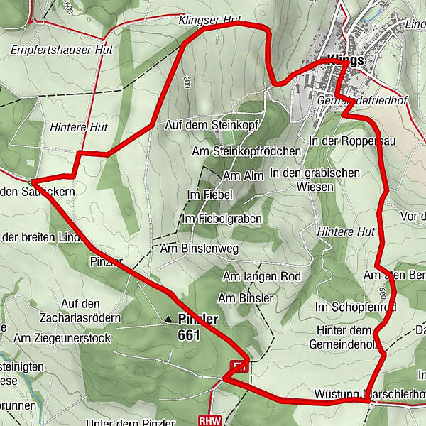
Klings
- Route
-
Klings0.0 kmAn der Koppe0.6 kmAm aten Berge1.5 kmWüstung Marschlerhof2.3 kmPinzler (661 m)3.7 kmBinsler4.0 kmKlings7.4 km
- Best season
-
JanFebMarAprMayJunJulAugSepOctNovDec
- Description
-
The Rhön-Rundweg 2 starts in the tranquil village of Klings. Starting from there, the path runs in a southerly direction. After 3 kilometers you reach the Hexenlinde not far from the Thuringia / Hesse border.
There are several legends connected to the 350-year-old Dutch linden tree. One tells of a hiker who was on his way from Dermbach to Tann on Walpurgis Night and got lost. He was led to a linden tree by a hunter and asked to play the clarinet. He complied with this request and received the instrument and a few silver coins afterwards as a gift. When the wanderer woke up the next morning, he realized that he had played music for witches. More info on the reason you can read an information board next to the witch's linden tree.
After the legendary tree, the route leads you to the hiking hut "Altenbergbaude". The small and cozy hut invites you to take a break. The view there rewards the hikers even more.
Then the path leads back to the starting point of the tour, Klings.
- Highest point
- 653 m
- Endpoint
-
Klings
- Height profile
-
 © outdooractive.com
 - Equipment
-
Sturdy shoes
Rain clothes
Sun protection at high temperatures
First aid kit
GPS navigation device or map
Sufficient drinks and provisions - Safety instructions
-
The tourist routes of the Rhön are mostly used by other active people (hikers, mountain bikers, cyclists, walkers, riders, cross-country skiers, etc.)
We ask all active nature sports enthusiasts to show consideration for one another. The same applies, of course, to nature - it is worth protecting. In the Rhön, therefore, nature sports should only be practiced in daylight on designated paths and areas.
- Tips
-
The hiking hut "Altenbergbaude" is only known to a few hikers in the Rhön and is well worth a trip.
- Directions
-
The starting point of the Rhön-Rundweg 2 in Klings can be reached via the A71. To do this, leave the motorway at exit 21 Meiningen-Nord. Then you drive on the B19 in the direction of Wasungen. In Wasungen, follow the signs in the direction of Kaltennordheim. Shortly before Kaltennordheim, turn right onto the B285 and cross the village. A short time later you reach the village of Diedorf. Here you turn left to Klings, where you can park in the center of the village.
- Public transportation
-
The starting point of the Rhön circular route can be reached by public transport. In the middle of the village there is a bus stop on which the following Wartburgmobil lines operate:
- Line 132: Dermbach - Diedorf - Empfertshausen - Zella - Glattbach - Dermbach
- Line 133: Dermbach - Andenhausen - Empfertshausen - Klings - Diedorf - Fischbach
- Parking

-

-
AuthorThe tour Rhön-Rundweg 2 - Klings - Rhön is used by outdooractive.com provided.