- Brief description
-
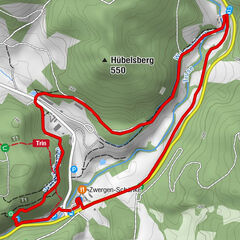
The circular route leads over a length of 9 kilometers from Roßdorf to the Bernhäuser Kutte. The path leads back to the starting point in Roßdorf over the Horn hill (578m).
- Difficulty
-
medium
- Rating
-
- Starting point
-
Village centre of Roßdorf
- Route
-
RoßdorfBernshausen4.0 kmRoßdorf9.0 km
- Best season
-
JanFebMarAprMayJunJulAugSepOctNovDec
- Description
-
The Rhön-Rundweg starts in the cozy village of Roßdorf. There is a small castle in the village. In the former moated castle, which was already mentioned in documents in 780, there are now a holiday apartments and a small campsite on the site.
The hiking trail leads towards the Bernshäuser Kutte, a sinkhole pond, which was created by the collapse of cavities in the surrounding sandstone.
From the Bernshäuser Kutte the circular hiking trail now runs steadily uphill to just before the summit of the Horn (578m). As at other locations in the Rhön, Celts lived on the Horn many hundreds of years ago. Remains of a rampart as well as finds (bronze axes and jewelry, etc. from approx. 2000-1000 BC) testify to this.
From the Horn the path runs downhill back to Roßdorf.
- Highest point
- 559 m
- Endpoint
-
Village centre of Roßdorf
- Height profile
-
 © outdooractive.com
 - Equipment
-
Sturdy shoes
Rain clothes
Sun protection at high temperatures
First aid kit
GPS navigation device or map
Sufficient drinks and provisions - Safety instructions
-
The tourist routes of the Rhön are mostly used by other active people (hikers, mountain bikers, cyclists, walkers, riders, cross-country skiers, etc.)
We ask all active nature sports enthusiasts to show consideration for one another. The same applies, of course, to nature - it is worth protecting. In the Rhön, therefore, nature sports should only be practiced in daylight on designated paths and areas.
- Tips
-
The circular sinkhole pond Bernshäuser Kutte is a highlight on the tour. Plan your rest there!
- Additional information
- Directions
-
You can drive to Roßdorf via the A4 or A71.
Leave the motorway A4 via exit 33 Friedewald and take the B62 in the direction of Vacha. In Vacha, continue on the B84 in the direction of Bad Salzungen. At Dorndorf, turn right onto the L1022 in the direction of Stadtlengsfeld and Dermbach and follow this to the small town of Hartschimmern, where you turn left into Urnshausen. Here you drive through Bernshausen and could start the hiking trail from there. Alternatively, continue on the main road through the village and shortly afterwards you will reach Roßdorf, the starting point of the circular hiking trail.
Leave the motorway A71 at exit 21 Meiningen-Nord. Then you drive on the B19 through Meiningen and on via Walldorf and Wasungen to Schwallungen. Leave the B19 at Schwallungen and follow the signs from there to Roßdorf.
- Public transportation
-
There is a bus stop in the center of Roßdorf. The following Meininger bus lines operate there:
- Line 443: Schmalkalden - Wehrnshausen - Roßdorf
- Line 444: Schmalkalden - Zillbach - Eckhardts
There is a bus stop in Bernshausen. The following Wartburgmobil bus lines run there:
- Line 121: Wiesenthal - Urnshausen - Dermbach - Stadtlengsfeld
- Line 131: Dermbach - Wiesenthal
- Parking

-

-
AuthorThe tour Rhön-Rundweg 2 Roßdorf - Rhön is used by outdooractive.com provided.


General info
-
Die Rhön / Thüringen
825
-
Hessisches Kegelspiel
278
-
Dermbach
40