- Brief description
-
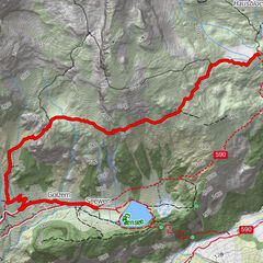
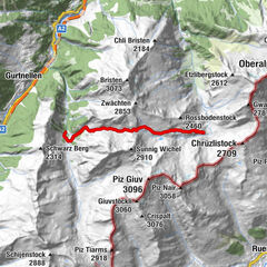
In autumn 1799, Russian General Suvorov and his army crossed through the Swiss Alps in order to oust the French from the country. The ViaSuworow follows the route of this campaign through breathtaking mountain landscape.
- Difficulty
-
medium
- Rating
-
- Starting point
-
Airolo
- Route
-
Airolo (1,175 m)0.2 kmSan Carlo0.5 kmMotto Bartola3.2 kmScima du Bòsc'3.3 kmTramiòra6.1 kmSan Gottardo7.6 kmCappella di San Gottardo7.6 kmScuderia7.7 kmOspizio del San Gottardo (2,091 m)7.7 kmAlte Sust7.7 kmGotthardpass 2106m8.3 kmMätteli12.2 kmGüetli16.2 kmCentral16.2 kmObergadmen16.3 kmBurg16.5 kmHospental (1,493 m)16.5 kmSpeiserestaurant zum Turm16.5 kmKath. Kirche Mariä Himmelfahrt16.5 kmHimmelbiel16.6 kmHospental (1,452 m)16.9 kmBahnhofgebäude16.9 kmAndermatt (1,447 m)20.3 kmAndermatt (1,436 m)20.4 kmUrnerloch21.3 kmTeufelsbrücke21.7 kmGöschenen (1,106 m)25.2 kmGöschenen (1,111 m)25.4 kmHinter Neiselen28.3 kmVorder Neiselen28.7 kmVorder Neiselen28.8 kmWattingen28.8 kmWassen UR (930 m)30.1 kmBeinhauskapelle30.2 kmPfaffensprung31.7 kmHäggrigen32.9 kmWiler33.9 kmGurtnellen (928 m)34.2 kmUnteraa34.5 kmMeitschligen37.6 kmHirschen40.8 kmKohlplatz40.9 kmMühlemätteli40.9 kmStern Post41.1 kmReussboden41.2 kmAmsteg41.3 km14-Nothelfer-Kapelle42.1 kmSilenen (510 m)44.2 kmKatholische Kirche St. Albin44.2 kmKapelle Rietli45.3 kmJagdmattkapelle48.3 kmErstfeld (475 m)49.0 kmAttinghausen (468 m)54.1 kmWalkermätteli56.1 kmVorstadt56.8 kmKapelle Oberes Heiliges Kreuz57.2 kmFEG Altdorf57.3 kmAltdorf (458 m)57.6 kmHöflispielplatz57.9 kmBalmermatte59.1 kmHartolfingen59.2 kmAntonius-Kapelle59.3 kmKohlplatz59.4 kmBürglen UR (525 m)59.5 kmTellskapelle59.6 kmPfarrkirche St. Peter und Paul59.6 kmAdler59.6 kmBelimatte59.7 kmGosmergartä59.7 kmZwyssigmatte59.8 kmSchützenhausmatte59.8 kmWebermätteli59.9 kmMuosermätteli59.9 kmPlanzermätteli60.1 kmGörimätteli60.3 kmStalden60.8 kmKinzigpass61.0 kmLoretokapelle St. Simon und Juda61.1 kmDer Gasthof61.2 kmBachergrundboden61.2 kmBaumgärtli61.5 kmLehmattli61.6 kmSigmanig61.6 kmRaindli62.1 kmTrudelingen62.6 kmSchachen63.6 kmSchroten64.0 kmBrickeracherberg65.4 kmOberer Acherberg65.6 kmGrossacherberg65.6 kmVorderer Acherberg65.7 kmHolzerberg66.2 kmHärderig67.1 kmBergstation Biel67.3 kmBerggasthaus Biel67.3 kmBergkapelle Biel67.8 kmVorderer Weissenboden67.9 kmSchutzhütte Chinzig70.3 kmChinzig Chulm Kappelle70.3 kmHintersten Hütten74.2 kmMittelsten Hütten74.5 kmVordersten Hütten75.4 kmAlpwirtschaft Lipplisbüel77.8 kmBergrestaurant Lipplisbüel78.6 kmGletschermühlen81.2 kmMuotathal81.6 kmGasthaus Hölloch82.5 kmStalden82.6 kmSchafmatt85.3 kmPragelpasshöhe91.0 kmGampel95.7 kmGasthaus Richisau96.7 kmRallischarten97.2 kmMoos97.9 kmGasthaus zum Klöntal99.9 kmSteppel100.2 kmRossbrünnen100.4 kmBlaaben Brünnen100.7 kmWissen Brünnen101.2 kmBärentritt103.8 kmOchsenwinggel105.1 kmChäsgadenboden105.5 kmKiosk105.8 kmGüntlenau106.0 kmRhodannenberg106.8 kmFulenchopf108.7 kmQuelle Löntschbord108.7 kmLöntschtobel109.3 kmCholgrüebli109.7 kmStaldengarten110.2 kmStalden110.3 kmAuli110.8 kmDurschen111.1 kmRiedern (529 m)111.7 kmNeuapostolische Kirche113.4 kmStadtkirche113.7 kmGlarus (474 m)114.0 kmBüel114.6 kmEnnenda (478 m)115.4 kmHolenstein115.7 kmLinthboden117.2 kmAueli117.5 kmUnterer Boden117.9 kmLängrüti118.0 kmNügaden118.3 kmWaldegg118.8 kmMitlödi (504 m)118.8 kmEnnetlinth118.9 kmLänggüetli119.2 kmSändli119.7 kmTschachen120.0 kmSchwanden (521 m)120.2 kmInslen120.4 kmSchwanden (521 m)120.6 kmErlen120.8 kmPlattenau120.8 kmHerren121.3 kmSool (637 m)121.3 kmLochsiten121.8 kmAllmeindli122.6 kmGinzen123.9 kmWart123.9 kmÄngi126.6 kmEngi (812 m)127.8 kmStrass127.9 kmBrämenhoschet128.5 kmMüli128.8 kmMatt (831 m)130.7 kmWisshus131.1 kmSand131.3 kmFur131.9 kmGrueben132.5 kmSulzbach134.1 kmSchwändi134.4 kmGasthaus Sonne135.8 kmDörfli135.8 kmSuworow-Cheller135.9 kmElm (977 m)136.1 kmEggli137.5 kmEgg137.9 kmElmen138.1 kmChüelaui138.5 kmVorderauen138.7 kmGeren139.0 kmJetzalp140.7 kmPanixerpass147.4 kmPanixerpasshütte147.7 kmCamona150.5 kmSur Vischnaunca157.4 kmCasa Vedra157.4 kmPanix (1,301 m)157.5 kmAlpina157.5 kmSogn Valentin Pigniu157.7 kmSut Resgia157.8 kmRuis (788 m)164.7 kmKatholische Kirche St. Andreas165.0 kmSax165.6 kmKapelle St. Maria Magdalena166.7 kmSpéz167.0 kmStiva Veglia167.2 kmReformierte Kirche Schnaus167.3 kmSchnaus (720 m)167.4 kmGrüneck168.5 kmCava168.7 kmLa Lutta168.9 kmIlanz (702 m)169.5 kmIlanz (698 m)169.6 km
- Best season
-
JanFebMarAprMayJunJulAugSepOctNovDec
- Description
-
Coming from Italy, the Russians crossed the Ticino border at Ponte Tresa, marched over the Monte Ceneri, through the Leventina valley and over the Gotthard, to push forward to Ursern and through the Reusstal valley as far as Altdorf. Resistance by the French at the Urnersee lake and in the Glarner lowlands forced Suvorov to evade them by marching over the Chinzig Chulm and Pragel passes and finally to retreat through the Sernftal valley and over the Panixer pass into the Surselva. The Russian troops left the region of the former Three Leagues alliance via the Rheintal valley in the direction of Russia.
The Suvorov memorials on the Gotthard and in the Schöllenen gorge are reminders of these dramatic events, as are the general's quarters in listed buildings such as the Muotathal Monastery and the Suvorov House in Elm.
In addition to the historic sites along the route, the natural setting is also exceptionally impressive. Rugged mountain valleys, scenic passes, mountain lakes and rivers can all be enjoyed without any worries - in contrast to Suvorov’s troops, who had to march the route under time pressure, enemy attacks and the onset of winter. - Directions
-
Stages:
55.1 Airolo–Gotthardpass
55.2 Gotthardpass–Andermatt
55.3 Andermatt–Wassen
55.4 Wassen–Altdorf
55.5 Altdorf–Biel-Chinzig
55.6 Biel-Chinzig–Muotathal
55.7 Muotathal–Hinter Klöntal
55.8 Hinter Klöntal–Glarus
55.9 Glarus–Elm
55.10 Elm–Pigniu
55.11 Pigniu–Ilanz - Highest point
- 2,395 m
- Endpoint
-
Ilanz
- Height profile
-
 © outdooractive.com
 - Tips
-
Book Package «Via Suworow» and benefit from the free luggage transport from hotel to hotel.
- Additional information
- Author
-
The tour 55 Via Suworow is used by outdooractive.com provided.


General info
-
Uri
1548
-
Stoos-Muotatal
846
-
Urnerboden
111