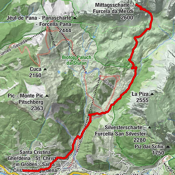
Zur Mittagsschachte

Logo Zur Mittagsschachte
Tour data
8.53km
1,519 - 2,594m
Distance
1,099hm
11hm
Ascent
06:00h
 
Duration
Brief description

Schwierige Bergwanderung im Naturparkt Puez Geisler.

Difficulty
difficult
Rating
Technique
Fitness
Landscape
Experience
Route
Sankt Christina in Gröden
0.0 km
Col da Mëssa
0.5 km
Plesdinaz (1,536 m)
0.9 km
Mesc da Paratoni
1.7 km
Baita Pramulin Hutte
2.2 km
Regensburgerhütte
5.7 km
Ncisles
6.1 km
Best season
Jan
Feb
Mar
Apr
May
Jun
Jul
Aug
Sep
Oct
Nov
Dec
Highest point
2,594 m

Overall rating

5

0

%

4

0

%

3

0

%

2

0

%

1

0

%

Error
An error has occurred. Please try again.
Thank you for your review

Rating has been deleted

GPS Downloads
  • GPX GPS Exchange Format (XML)
  • KML Google Earth, Google Maps
QR Download Codes for Mobile Phones

Trail conditions

Asphalt
Gravel
Meadow
Forest
Rock
Exposed

Popular tours in the area

The Keschtnweg chsestnut trail from Brixen to Klausen

difficult Hiking
15.72km | 1060hm | 06:30h

Peitlerkofel (2875 m)

medium Hiking
11.64km | 873hm | 05:40h

Bärenfalle - Hammerwand

difficult Hiking
13.83km | 1269hm | 06:45h